Mullica Township, New Jersey
| Mullica Township, New Jersey | |
|---|---|
| Township | |
| Township of Mullica | |
|
Pleasant Mills | |
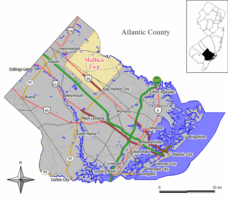 Map of Mullica Township in Atlantic County. Inset: Location of Atlantic County highlighted in the State of New Jersey. | |
 Census Bureau map of Mullica Township, New Jersey | |
| Coordinates: 39°36′13″N 74°40′41″W / 39.603687°N 74.678036°WCoordinates: 39°36′13″N 74°40′41″W / 39.603687°N 74.678036°W[1][2] | |
| Country |
|
| State |
|
| County | Atlantic |
| Incorporated | March 13, 1838 |
| Named for | Eric Pålsson Mullica |
| Government[3] | |
| • Type | Township |
| • Body | Township Committee |
| • Mayor | James Brown (term ends December 31, 2016)[4][5] |
| • Clerk | Kimberly Johnson[6] |
| Area[1] | |
| • Total | 56.902 sq mi (147.377 km2) |
| • Land | 56.421 sq mi (146.130 km2) |
| • Water | 0.481 sq mi (1.246 km2) 0.85% |
| Area rank |
25th of 566 in state 4th of 23 in county[1] |
| Elevation[7] | 56 ft (17 m) |
| Population (2010 Census)[8][9][10] | |
| • Total | 6,147 |
| • Estimate (2015)[11] | 6,098 |
| • Rank |
338th of 566 in state 15th of 23 in county[12] |
| • Density | 108.9/sq mi (42.0/km2) |
| • Density rank |
539th of 566 in state 21st of 23 in county[12] |
| Time zone | Eastern (EST) (UTC-5) |
| • Summer (DST) | Eastern (EDT) (UTC-4) |
| ZIP code | 08217 - Elwood[13] |
| Area code(s) | 609[14] |
| FIPS code | 3400149410[1][15][16] |
| GNIS feature ID | 0882053[17] |
| Website |
www |

Mullica Township is a township in Atlantic County, New Jersey, United States. As of the 2010 United States Census, the township's population was 6,147[8][9][10] reflecting an increase of 235 (+4.0%) from the 5,912 counted in the 2000 Census, which had in turn increased by 16 (+0.3%) from the 5,896 counted in the 1990 Census.[18]
Mullica Township was incorporated as a township by an act of the New Jersey Legislature on March 13, 1838, from the western section of Galloway Township. Egg Harbor City was created from portions of the township on June 14, 1858, while the Town of Hammonton was created and split off on March 5, 1866.[19]
The township and its river were named after Eric Pålsson Mullica, an early Finnish settler born in 1636 who founded a homestead on the river after moving there from the vicinity of Philadelphia, and who later moved to Mullica Hill in Gloucester County.[20][21] When used as a common noun, mullikka is the Finnish term for a bull calf.
Geography
According to the United States Census Bureau, the township had a total area of 56.902 square miles (147.377 km2), including 56.421 square miles (146.130 km2) of land and 0.481 square miles (1.246 km2) of water (0.85%).[1][2]
Despite a relatively small population, Mullica Township comprises many small communities. Elwood is an unincorporated community and census-designated place (CDP) (with a 2010 Census population of 1,437[22]) located within Mullica Township.[23][24][25]
Other unincorporated communities, localities and place names located partially or completely within the township include Amatol, Colwell, Dacosta, Devonshire, East Hammonton, Indian Cabin, Nesco, New Columbia, Pleasant Mills, Speedway, Sweetwater, Weekstown, Wescoatville, West Egg Harbor and Woodland.[26][27] Unincorporated communities in Mullica Township are largely identified by landmarks such as the Elwood Deli, the Sweetwater Casino, or the Weekstown Firehouse. The small unincorporated communities within the township engender a particularly high level of pride, and many Mullica Township residents refer to themselves as residents of their unincorporated community, before referring to themselves as residents of Mullica Township.
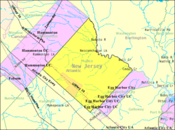
The township is located in the northeast portion of Atlantic County. It is bounded on the north by Washington Township in Burlington County; on the east by Egg Harbor City; on the south by Hamilton Township; and on the west by the Town of Hammonton. The Township is approximately 13 miles (21 km) outside of Atlantic City and 40 miles (64 km) outside of Philadelphia.
The township is one of 56 South Jersey municipalities that are included within the New Jersey Pinelands National Reserve, a protected natural area of unique ecology covering 1,100,000 acres (450,000 ha), that has been classified as a United States Biosphere Reserve and established by Congress in 1978 as the nation's first National Reserve.[28] All of the township is included in the state-designated Pinelands Area, which includes portions of Atlantic County, along with areas in Burlington, Camden, Cape May, Cumberland, Gloucester and Ocean counties.[29]
Demographics
| Historical population | |||
|---|---|---|---|
| Census | Pop. | %± | |
| 1840 | 1,056 | — | |
| 1850 | 918 | −13.1% | |
| 1860 | 1,600 | * | 74.3% |
| 1870 | 861 | * | −46.2% |
| 1880 | 717 | −16.7% | |
| 1890 | 697 | −2.8% | |
| 1900 | 880 | 26.3% | |
| 1910 | 811 | −7.8% | |
| 1920 | 1,166 | 43.8% | |
| 1930 | 1,425 | 22.2% | |
| 1940 | 1,500 | 5.3% | |
| 1950 | 1,804 | 20.3% | |
| 1960 | 2,944 | 63.2% | |
| 1970 | 3,391 | 15.2% | |
| 1980 | 5,243 | 54.6% | |
| 1990 | 5,896 | 12.5% | |
| 2000 | 5,912 | 0.3% | |
| 2010 | 6,147 | 4.0% | |
| Est. 2015 | 6,098 | [11][30] | −0.8% |
| Population sources: 1840-2000[31] 1840-1920[32] 1840[33] 1850-1870[34] 1850[35] 1870[36] 1880-1890[37] 1890-1910[38] 1910-1930[39] 1930-1990[40] 2000[41][42] 2010[8][9][10] * = Lost territory in previous decade.[19] | |||
2010 Census
The 2010 United States Census counted 6,147 people, 2,154 households, and 1,631 families residing in the township. The population density was 108.9 per square mile (42.0/km2). The township contained 2,360 housing units at an average density of 41.8 per square mile (16.1/km2). The racial makeup of the township was 83.26% (5,118) White, 5.68% (349) Black or African American, 0.23% (14) Native American, 0.68% (42) Asian, 0.03% (2) Pacific Islander, 7.19% (442) from other races, and 2.93% (180) from two or more races. Hispanics or Latinos of any race were 17.02% (1,046) of the population.[8]
Out of a total of 2,154 households, 30.5% had children under the age of 18 living with them, 57.4% were married couples living together, 11.7% had a female householder with no husband present, and 24.3% were non-families. 18.4% of all households were made up of individuals, and 8.4% had someone living alone who was 65 years of age or older. The average household size was 2.81 and the average family size was 3.19.[8]
In the township, 23.1% of the population were under the age of 18, 8.2% from 18 to 24, 23.5% from 25 to 44, 31.9% from 45 to 64, and 13.3% who were 65 years of age or older. The median age was 41.7 years. For every 100 females the census counted 100.6 males, but for 100 females at least 18 years old, it was 100.1 males.[8]
The Census Bureau's 2006-2010 American Community Survey showed that (in 2010 inflation-adjusted dollars) median household income was $54,730 (with a margin of error of +/- $11,733) and the median family income was $62,000 (+/- $10,758). Males had a median income of $42,931 (+/- $9,882) versus $41,716 (+/- $5,514) for females. The per capita income for the township was $26,217 (+/- $3,264). About 3.6% of families and 6.5% of the population were below the poverty line, including 8.1% of those under age 18 and 5.4% of those age 65 or over.[43]
2000 Census
As of the 2000 United States Census[15] there were 5,912 people, 2,044 households, and 1,537 families residing in the township. The population density was 104.5 people per square mile (40.3/km²). There were 2,176 housing units at an average density of 38.5 per square mile (14.8/km²). The racial makeup of the township was 80.58% White, 6.28% African American, 0.27% Native American, 0.83% Asian, 0.12% Pacific Islander, 8.61% from other races, and 3.32% from two or more races. Hispanic or Latino of any race were 16.49% of the population.[41][42]
There were 2,044 households out of which 35.9% had children under the age of 18 living with them, 59.6% were married couples living together, 10.0% had a female householder with no husband present, and 24.8% were non-families. 19.4% of all households were made up of individuals and 7.9% had someone living alone who was 65 years of age or older. The average household size was 2.87 and the average family size was 3.30.[41][42]
In the township the population was spread out with 27.0% under the age of 18, 7.4% from 18 to 24, 31.1% from 25 to 44, 23.9% from 45 to 64, and 10.7% who were 65 years of age or older. The median age was 37 years. For every 100 females there were 101.3 males. For every 100 females age 18 and over, there were 101.1 males.[41][42]
The median income for a household in the township was $50,417, and the median income for a family was $55,143. Males had a median income of $40,033 versus $29,965 for females. The per capita income for the township was $19,764. About 5.7% of families and 7.8% of the population were below the poverty line, including 11.3% of those under age 18 and 10.8% of those age 65 or over.[41][42]
Government
Local government
Mullica Township operates under the Township Committee form of New Jersey municipal government.The five-member Township Committee is elected directly by the voters at-large in partisan elections to serve three-year terms of office on a staggered basis, with either one or two seats coming up for election each year as part of the November general election in a three-year cycle.[3][20][44] The mayor and deputy mayor are selected at an annual reorganization meeting by the Committee from among its members to serve terms of one year. The mayor presides over Township Committee meetings.
As of 2016, members of the Mullica Township Committee are Mayor James R. Brown (R, term on committee and as mayor ends December 31, 2016; Director of Revenue and Finance), Deputy Mayor Lawrence E. Riffle, Jr. (R, term on committee and as deputy mayor ends 2016), Edward Hagaman (R, 2018), Christopher Silva (R, 2017) and John Walther (R, 2018).[4][45][46][47][48][49]
Federal, state and county representation
Mullica Township is located in the 2nd Congressional District[50] and is part of New Jersey's 2nd state legislative district.[9][51][52]
New Jersey's Second Congressional District is represented by Frank LoBiondo (R, Ventnor City).[53] New Jersey is represented in the United States Senate by Cory Booker (D, Newark, term ends 2021)[54] and Bob Menendez (D, Paramus, 2019).[55][56]
For the 2016–2017 session (Senate, General Assembly), the 2nd Legislative District of the New Jersey Legislature is represented in the State Senate by Jim Whelan (D, Atlantic City) and in the General Assembly by Chris A. Brown (R, Ventnor City) and Vince Mazzeo (D, Northfield).[57] The Governor of New Jersey is Chris Christie (R, Mendham Township).[58] The Lieutenant Governor of New Jersey is Kim Guadagno (R, Monmouth Beach).[59]
Atlantic County is governed by a directly elected executive and a nine-member Board of Chosen Freeholders, responsible for legislation. The executive serves a four-year term and the freeholders are elected to staggered three-year terms, of which four are elected from the county on an at-large basis and five of the freeholders represent equally populated districts.[60][61] As of 2015, Atlantic County's Executive is Republican Dennis Levinson, whose term of office ends December 31, 2015.[62] Members of the Board of Chosen Freeholders are Chairman Frank D. Formica, Freeholder District 2, including Atlantic City (part), Egg Harbor Township (part), Linwood, Longport, Margate, Northfield, Somers Point and Ventnor (R, 2015),[63] Vice Chairman James A. Bertino, Freeholder District 5, including Buena Borough, Buena Vista Township, Corbin City, Egg Harbor City, Estell Manor, Folsom, Hamilton Township (part), Hammonton, Mullica Township and Weymouth (R, 2015),[64] Colin G. Bell, Freeholder At-Large (R, 2015),[65] John Carman, Freeholder District 3, including Egg Harbor Township (part) and Hamilton Township (part) (R, 2017),[66] Ernest D. Coursey, Freeholder District 1, including Atlantic City (part), Egg Harbor Township (part) and Pleasantville (R, 2016),[67] Richard Dase, Freeholder District 4, including Absecon, Brigantine, Galloway Township and Port Republic (D, 2016),[68] Alexander C. Marino, Freeholder At-Large (R, 2017),[69] Will Pauls, Freeholder At-Large (R, 2016)[70] and John W. Risley, Freeholder At-Large (R, 2017).[71][72][73] Constitutional officers are County Clerk Edward P. McGettigan (2016),[74] Sheriff Frank X. Balles (R, 2017)[75] and Surrogate James Curcio (2015).[76][77]
Politics
As of March 23, 2011, there were a total of 4,077 registered voters in Mullica Township, of which 917 (22.5% vs. 30.5% countywide) were registered as Democrats, 1,336 (32.8% vs. 25.2%) were registered as Republicans and 1,821 (44.7% vs. 44.3%) were registered as Unaffiliated. There were 3 voters registered to other parties.[78] Among the township's 2010 Census population, 66.3% (vs. 58.8% in Atlantic County) were registered to vote, including 86.3% of those ages 18 and over (vs. 76.6% countywide).[78][79]
In the 2012 presidential election, Republican Mitt Romney received 1,439 votes (49.1% vs. 41.1% countywide), ahead of Democrat Barack Obama with 1,430 votes (48.8% vs. 57.9%) and other candidates with 41 votes (1.4% vs. 0.9%), among the 2,933 ballots cast by the township's 4,249 registered voters, for a turnout of 69.0% (vs. 65.8% in Atlantic County).[80][81] In the 2008 presidential election, Republican John McCain received 1,512 votes (49.5% vs. 41.6% countywide), ahead of Democrat Barack Obama with 1,467 votes (48.0% vs. 56.5%) and other candidates with 43 votes (1.4% vs. 1.1%), among the 3,057 ballots cast by the township's 4,278 registered voters, for a turnout of 71.5% (vs. 68.1% in Atlantic County).[82] In the 2004 presidential election, Republican George W. Bush received 1,487 votes (53.5% vs. 46.2% countywide), ahead of Democrat John Kerry with 1,244 votes (44.8% vs. 52.0%) and other candidates with 24 votes (0.9% vs. 0.8%), among the 2,778 ballots cast by the township's 3,811 registered voters, for a turnout of 72.9% (vs. 69.8% in the whole county).[83]
In the 2013 gubernatorial election, Republican Chris Christie received 1,315 votes (67.8% vs. 60.0% countywide), ahead of Democrat Barbara Buono with 553 votes (28.5% vs. 34.9%) and other candidates with 34 votes (1.8% vs. 1.3%), among the 1,939 ballots cast by the township's 4,288 registered voters, yielding a 45.2% turnout (vs. 41.5% in the county).[84][85] In the 2009 gubernatorial election, Republican Chris Christie received 1,131 votes (53.4% vs. 47.7% countywide), ahead of Democrat Jon Corzine with 801 votes (37.8% vs. 44.5%), Independent Chris Daggett with 102 votes (4.8% vs. 4.8%) and other candidates with 35 votes (1.7% vs. 1.2%), among the 2,117 ballots cast by the township's 4,111 registered voters, yielding a 51.5% turnout (vs. 44.9% in the county).[86]
Education
The Mullica Township Schools serve students in pre-Kindergarten through eighth grade. As of the 2011-12 school year, the district's two schools had an enrollment of 724 students and 57.6 classroom teachers (on an FTE basis), for a student–teacher ratio of 12.57:1.[87] Schools in the district (with 2011-12 enrollment data from the National Center for Education Statistics.[88]) are Mullica Township Elementary School[89] with 407 students in grades pre-K - 4 and Mullica Township Middle School[90] with 317 students in grades 5 - 8.[91]
Students in ninth through twelfth grades attend Cedar Creek High School, which is located in the northern section of Egg Harbor City and opened to students in September 2010.[92] The school is one of three high schools operated as part of the Greater Egg Harbor Regional High School District, which also includes the constituent municipalities of Egg Harbor City, Galloway Township and Hamilton Township, and participates in sending/receiving relationships with Port Republic and Washington Township (Burlington County).[93] Cedar Creek High School is zoned to serve students from Egg Harbor City, Mullica Township, Port Republic and Washington Township, while students in portions of Galloway and Hamilton townships have the opportunity to attend Cedar Creek through the school of choice program or through attendance in magnet programs offered at Cedar Creek.[94][95]
Students from Mullica Township, and all of Atlantic County, have the option to attend the career technical programs and full-time career academies offered by the Atlantic County Institute of Technology located in the Mays Landing section of Hamilton Township[96] or the Charter-Tech High School for the Performing Arts, located in Somers Point.[97]
Transportation
Roads and highways
As of May 2010, the township had a total of 106.24 miles (170.98 km) of roadways, of which 59.91 miles (96.42 km) were maintained by the municipality, 38.26 miles (61.57 km) by Atlantic County and 8.07 miles (12.99 km) by the New Jersey Department of Transportation.[98] Many of the street names in Mullica Township are used on multiple, sometimes intersecting roads within the township, or reused from adjacent municipalities. Examples are Elwood Rd, Weekstown Road, Pleasant Mills Road, and Columbia Road. In fact, 7th Ave has two major intersections, one with County Road 612 and the other with County Road 643. Both of the county roads are named Weekstown Road at the point where they intersect with 7th Ave, approximately 2.5 miles away from each other.
U.S. Route 30 (White Horse Pike) passes through Mullica Township.[99]
Public transportation
New Jersey Transit provides bus service in the township on the 554 route that runs between Lindenwold station and Atlantic City.[100][101]
Notable people
People who were born in, residents of, or otherwise closely associated with Mullica Township include:
- Joseph Fralinger (1848-1927), businessman and confectioner, known for being the most successful merchandiser of salt water taffy.[102]
- Eric Pålsson Mullica (1636-c.1704), an early Finnish settler for whom Mullica Township was named.
- Charles Saalmann (1836-1909), captain of Union infantry during the American Civil War who established the Black Rose Vineyard.[103]
See also
- List of New Jersey rivers
- Mullica Hill, New Jersey, a census-designated place located within Harrison Township, New Jersey, in Gloucester County
- Mullica River, a river in southern New Jersey once known as the Little Egg Harbor River
References
- 1 2 3 4 5 2010 Census Gazetteer Files: New Jersey County Subdivisions, United States Census Bureau. Accessed May 21, 2015.
- 1 2 US Gazetteer files: 2010, 2000, and 1990, United States Census Bureau. Accessed September 4, 2014.
- 1 2 2012 New Jersey Legislative District Data Book, Rutgers University Edward J. Bloustein School of Planning and Public Policy, March 2013, p. 13.
- 1 2 Township Committee, Mullica Township. Accessed June 14, 2016.
- ↑ 2016 New Jersey Mayors Directory, New Jersey Department of Community Affairs. Accessed June 14, 2016.
- ↑ Municipal Clerk, Mullica Township. Accessed November 30, 2011.
- ↑ U.S. Geological Survey Geographic Names Information System: Township of Mullica, Geographic Names Information System. Accessed March 8, 2013.
- 1 2 3 4 5 6 DP-1 - Profile of General Population and Housing Characteristics: 2010 for Mullica township, Atlantic County, New Jersey, United States Census Bureau. Accessed November 30, 2011.
- 1 2 3 4 Municipalities Grouped by 2011-2020 Legislative Districts, New Jersey Department of State, p. 2. Accessed January 6, 2013.
- 1 2 3 Table DP-1. Profile of General Demographic Characteristics: 2010 for Mullica township, New Jersey Department of Labor and Workforce Development. Accessed November 30, 2011.
- 1 2 PEPANNRES - Annual Estimates of the Resident Population: April 1, 2010 to July 1, 2015 - 2015 Population Estimates for New Jersey municipalities, United States Census Bureau. Accessed May 22, 2016.
- 1 2 GCT-PH1 Population, Housing Units, Area, and Density: 2010 - State -- County Subdivision from the 2010 Census Summary File 1 for New Jersey, United States Census Bureau. Accessed September 19, 2012.
- ↑ Look Up a ZIP Code for Elwood, NJ, United States Postal Service. Accessed September 19, 2012.
- ↑ Area Code Lookup - NPA NXX for Elwood, NJ, Area-Codes.com. Accessed October 6, 2014.
- 1 2 American FactFinder, United States Census Bureau. Accessed September 4, 2014.
- ↑ A Cure for the Common Codes: New Jersey, Missouri Census Data Center. Accessed September 19, 2012.
- ↑ US Board on Geographic Names, United States Geological Survey. Accessed September 4, 2014.
- ↑ Table 7. Population for the Counties and Municipalities in New Jersey: 1990, 2000 and 2010, New Jersey Department of Labor and Workforce Development, February 2011. Accessed September 19, 2012.
- 1 2 Snyder, John P. The Story of New Jersey's Civil Boundaries: 1606-1968, Bureau of Geology and Topography; Trenton, New Jersey; 1969. p. 70. Accessed September 19, 2012.
- 1 2 About Mullica, Mullica Township. Accessed August 3, 2006.
- ↑ Hutchinson, Viola L. The Origin of New Jersey Place Names, New Jersey Public Library Commission, May 1945. Accessed September 98, 2015.
- ↑ DP-1 - Profile of General Population and Housing Characteristics: 2010 Demographic Profile Data for Elwood CDP, New Jersey, United States Census Bureau. Accessed September 19, 2012.
- ↑ GCT-PH1 - Population, Housing Units, Area, and Density: 2010 - County -- County Subdivision and Place from the 2010 Census Summary File 1 for Atlantic County, New Jersey, United States Census Bureau. Accessed July 8, 2015.
- ↑ 2006-2010 American Community Survey Geography for New Jersey, United States Census Bureau. Accessed July 8, 2015.
- ↑ New Jersey: 2010 - Population and Housing Unit Counts - 2010 Census of Population and Housing (CPH-2-32), United States Census Bureau, August 2012. Accessed July 8, 2015.
- ↑ Locality Search, State of New Jersey. Accessed May 21, 2015.
- ↑ Local Government Budget Review: Township of Mullica, New Jersey Department of Treasury, January 2002. Accessed September 19, 2012. "Mullica Township was incorporated in 1838. It is located in southern New Jersey within the western sections of Atlantic County along Route 30, or what is more commonly known as the White Horse Pike. It includes various communities, such as Sweetwater, Nesco, Elwood, Devonshire, Dacosta, and Weekstown."
- ↑ The Pinelands National Reserve, New Jersey Pinelands Commission. Accessed November 19, 2013.
- ↑ Pinelands Municipalities, New Jersey Pinelands Commission, April 2003. Accessed November 19, 2013.
- ↑ Census Estimates for New Jersey April 1, 2010 to July 1, 2015, United States Census Bureau. Accessed May 22, 2016.
- ↑ Barnett, Bob. Population Data for Atlantic County Municipalities, 1840 - 2010, WestJersey.org. December 6, 2010. Accessed September 19, 2012.
- ↑ Compendium of censuses 1726-1905: together with the tabulated returns of 1905, New Jersey Department of State, 1906. Accessed October 24, 2013.
- ↑ Bowen, Francis. American Almanac and Repository of Useful Knowledge for the Year 1843, p. 232, David H. Williams, 1842. Accessed October 24, 2013.
- ↑ Raum, John O. The History of New Jersey: From Its Earliest Settlement to the Present Time, Volume 1, p. 273, J. E. Potter and company, 1877. Accessed October 24, 2013. "Mullica contained in 1850 a population of 2,933; in 1860, 1,600; and in 1870, 2,265." Population listed here conflicts with the 918 listed for 1850 (the 2,015 for Hamilton Township is included here) and 861 for 1870 (the data here includes the 1,404 for Hammonton).
- ↑ Debow, James Dunwoody Brownson. The Seventh Census of the United States: 1850, p. 137. R. Armstrong, 1853. Accessed October 24, 2013.
- ↑ Staff. A compendium of the ninth census, 1870, p. 259. United States Census Bureau, 1872. Accessed October 24, 2013. The 2,265 listed for Mullica includes the 1,404 for Hammonton
- ↑ Porter, Robert Percival. Preliminary Results as Contained in the Eleventh Census Bulletins: Volume III - 51 to 75, p. 97. United States Census Bureau, 1890. Accessed October 24, 2013.
- ↑ Thirteenth Census of the United States, 1910: Population by Counties and Minor Civil Divisions, 1910, 1900, 1890, United States Census Bureau, p. 335. Accessed September 19, 2012.
- ↑ Fifteenth Census of the United States : 1930 - Population Volume I, United States Census Bureau, p. 714. Accessed January 16, 2012.
- ↑ Table 6. New Jersey Resident Population by Municipality: 1930 - 1990, New Jersey Department of Labor and Workforce Development. Accessed June 28, 2015.
- 1 2 3 4 5 Census 2000 Profiles of Demographic / Social / Economic / Housing Characteristics for Mullica township, Atlantic County, New Jersey, United States Census Bureau. Accessed September 19, 2012.
- 1 2 3 4 5 DP-1: Profile of General Demographic Characteristics: 2000 - Census 2000 Summary File 1 (SF 1) 100-Percent Data for Mullica township, Atlantic County, New Jersey, United States Census Bureau. Accessed September 19, 2012.
- ↑ DP03: Selected Economic Characteristics from the 2006-2010 American Community Survey 5-Year Estimates for Mullica township, Atlantic County, New Jersey, United States Census Bureau. Accessed December 25, 2011.
- ↑ "Forms of Municipal Government in New Jersey", p. 7. Rutgers University Center for Government Studies. Accessed June 3, 2015.
- ↑ 2016 Municipal User Friendly Budget, Mullica Township. Accessed June 14, 2016.
- ↑ Municipal Governments in Atlantic County, Atlantic County, New Jersey, updated June 2, 2016. Accessed June 14, 2016.
- ↑ General Election November 3, 2015 Official Results, Atlantic County, New Jersey Clerk. Accessed June 14, 2016.
- ↑ General Election Results - November 4, 2014 Official Results, Atlantic County, New Jersey Clerk. Accessed June 14, 2016.
- ↑ General Election November 5, 2013 Official Results, Atlantic County, New Jersey Clerk. Accessed June 14, 2016.
- ↑ Plan Components Report, New Jersey Redistricting Commission, December 23, 2011. Accessed January 6, 2013.
- ↑ 2016 New Jersey Citizen's Guide to Government, p. 61, New Jersey League of Women Voters. Accessed July 20, 2016.
- ↑ Districts by Number for 2011-2020, New Jersey Legislature. Accessed January 6, 2013.
- ↑ Directory of Representatives: New Jersey, United States House of Representatives. Accessed January 5, 2012.
- ↑ About Cory Booker, United States Senate. Accessed January 26, 2015. "He now owns a home and lives in Newark's Central Ward community."
- ↑ Biography of Bob Menendez, United States Senate, January 26, 2015. "He currently lives in Paramus and has two children, Alicia and Robert."
- ↑ Senators of the 114th Congress from New Jersey. United States Senate. Accessed January 26, 2015. "Booker, Cory A. - (D - NJ) Class II; Menendez, Robert - (D - NJ) Class I"
- ↑ Legislative Roster 2016-2017 Session, New Jersey Legislature. Accessed January 17, 2016.
- ↑ "About the Governor". State of New Jersey. Retrieved 2010-01-21.
- ↑ "About the Lieutenant Governor". State of New Jersey. Retrieved 2010-01-21.
- ↑ 2013 Atlantic County District Map, Atlantic County, New Jersey. Accessed March 7, 2015.
- ↑ Board of Chosen Freeholders, Atlantic County, New Jersey. Accessed March 7, 2015.
- ↑ County Executive, Atlantic County, New Jersey. Accessed March 7, 2015.
- ↑ Frank D. Formica, Atlantic County, New Jersey. Accessed March 7, 2015.
- ↑ James A. Bertino, Atlantic County, New Jersey. Accessed March 7, 2015.
- ↑ Colin G. Bell, Atlantic County, New Jersey. Accessed March 7, 2015.
- ↑ John Carman, Atlantic County, New Jersey. Accessed March 7, 2015.
- ↑ Ernest D. Coursey, Atlantic County, New Jersey. Accessed March 7, 2015.
- ↑ Richard Dase, Atlantic County, New Jersey. Accessed March 7, 2015.
- ↑ Alexander C. Marino, Atlantic County, New Jersey. Accessed March 7, 2015.
- ↑ Will Pauls, Atlantic County, New Jersey. Accessed March 7, 2015.
- ↑ John W. Risley, Atlantic County, New Jersey. Accessed March 7, 2015.
- ↑ Atlantic County Board of Chosen Freeholders, Atlantic County, New Jersey. Accessed March 7, 2015.
- ↑ 2014 Atlantic County Board of Chosen Freeholders, Atlantic County, New Jersey. Accessed March 7, 2015.
- ↑ Ed McGettigan, Atlantic County Clerk. Accessed March 7, 2015.
- ↑ Frank X. Balles, Sheriff, Atlantic County Sheriff's Office. Accessed March 7, 2015.
- ↑ Atlantic County Surrogate's Court, Atlantic County, New Jersey. Accessed March 7, 2015.
- ↑ Constitutional Officers, Atlantic County, New Jersey. Accessed March 7, 2015.
- 1 2 Voter Registration Summary - Atlantic, New Jersey Department of State Division of Elections, March 23, 2011. Accessed December 24, 2014.
- ↑ GCT-P7: Selected Age Groups: 2010 - State -- County Subdivision; 2010 Census Summary File 1 for New Jersey, United States Census Bureau. Accessed December 24, 2014.
- ↑ Presidential November 6, 2012 General Election Results - Atlantic County, New Jersey Department of State Division of Elections, March 15, 2013. Accessed December 24, 2014.
- ↑ Number of Registered Voters and Ballots Cast November 6, 2012 General Election Results - Atlantic County, New Jersey Department of State Division of Elections, March 15, 2013. Accessed December 24, 2014.
- ↑ 2008 Presidential General Election Results: Atlantic County, New Jersey Department of State Division of Elections, December 23, 2008. Accessed December 24, 2014.
- ↑ 2004 Presidential Election: Atlantic County, New Jersey Department of State Division of Elections, December 13, 2004. Accessed December 24, 2014.
- ↑ 2013 Governor: Atlantic County, New Jersey Department of State Division of Elections, January 29, 2014. Accessed December 24, 2014.
- ↑ Number of Registered Voters and Ballots Cast November 5, 2013 General Election Results : Atlantic County, New Jersey Department of State Division of Elections, January 29, 2014. Accessed December 24, 2014.
- ↑ 2009 Governor: Atlantic County, New Jersey Department of State Division of Elections, December 31, 2009. Accessed December 24, 2014.
- ↑ District information for Mullica Township School District, National Center for Education Statistics. Accessed November 30, 2014.
- ↑ School Data for the Mullica Township Schools, National Center for Education Statistics. Accessed November 30, 2014.
- ↑ Mullica Township Elementary School, Mullica Township Schools. Accessed November 30, 2014.
- ↑ Mullica Township Middle School, Mullica Township Schools. Accessed November 30, 2014.
- ↑ New Jersey School Directory for the Mullica Township Schools, New Jersey Department of Education. Accessed November 30, 2014.
- ↑ Cedar Creek High School 2013 Report Card Narrative, New Jersey Department of Education. Accessed June 14, 2016. "Cedar Creek High School opened its doors for the first time September 7, 2010 with only 9th and 10th grade students. For the 2011/2012 school year, we grew to include grades 9 through 11. Serving students from six communities within the Greater Egg Harbor Regional High School District, Cedar Creek graduated its first class at the conclusion of the 2012/2013 school year."
- ↑ Greater Egg Harbor Regional School District 2015 Report Card Narrative, New Jersey Department of Education. Accessed June 5, 2016. "The Greater Egg Harbor Regional High School District serves the communities of Galloway Township, Hamilton Township, Egg Harbor City, Mullica Township and participates in receiving relationships with Port Republic and Washington Township. The geographic area of the district is the largest in the state, covering 324 square miles. The student body of each of the district's three comprehensive high schools, Absegami High School, Cedar Creek High School, and Oakcrest High School, reflects the socioeconomic and ethnic diversity of this geographic area."
- ↑ Student Population, Cedar Creek High School. Accessed November 30, 2014. "We will serve as the high school for the communities of Mullica Township, Egg Harbor City, Port Republic, and the Green Bank area of Washington Township. Students from specific geographic areas of Galloway and Hamilton Townships (School of Choice Program) and the entirety of Galloway and Hamilton Townships through the Magnet Programs (Engineering and Environmental Sciences) will have the option of attending CCHS."
- ↑ Policy 5120 Assignment of Pupils, Greater Egg Harbor Regional High School District. Accessed November 30, 2014. "Pupils shall attend the school located in the attendance area of their residence. The attendance areas for the Greater Egg Harbor Regional High School District shall be as follows: 1. Pupils who reside in Egg Harbor City shall attend Cedar Creek High School. 2. Pupils who reside in Galloway Township shall attend Absegami High School. 3. Pupils who reside in Hamilton Township shall attend Oakcrest High School 4. Pupils who reside in Mullica Township shall attend Cedar Creek High School 5. Pupils who reside in Port Republic and Washington Township shall attend Cedar Creek High School."
- ↑ About Us, Atlantic County Institute of Technology. Accessed October 24, 2013.
- ↑ Profile, Charter-Tech High School for the Performing Arts. Accessed November 19, 2013.
- ↑ Atlantic County Mileage by Municipality and Jurisdiction, New Jersey Department of Transportation, May 2010. Accessed November 19, 2013.
- ↑ U.S. Route 30 Straight Line Diagram, New Jersey Department of Transportation. Accessed October 24, 2013.
- ↑ Atlantic County Bus / Rail Connections, New Jersey Transit, backed up by the Internet Archive as of July 26, 2010. Accessed November 19, 2013.
- ↑ South Jersey Transit Guide, Cross County Connection, as of April 1, 2010. Accessed November 19, 2013.
- ↑ Schwartz, David. "Sweet Storm", '"Casino Connection, May 22, 2007. Accessed September 14, 2016. "Fralinger, born in Sweetwater, Atlantic County in 1848, started off as a glass blower but later moved to Philadelphia, where he ran a fish market before managing several baseball clubs."
- ↑ Annual Report, Volume 15, p. 365. New Jersey Board of Agriculture, 1888. Accessed July 8, 2015. "Like my predecessor Mr. Hoffman, I must make complaint that but very few of the many to whom I sent the circulars of the State Board have returned them with answers; and I am able to tender my thanks only to Captain Charles D. Saalmann of Mullica township; Hermann Henschel and Hermann Keyser, of Galloway township."
External links
- Mullica Township website
- Mullica Township Schools
- Mullica Township Schools's 2014–15 School Report Card from the New Jersey Department of Education
- School Data for the Mullica Township Schools, National Center for Education Statistics
- Oakcrest High School website
- Greater Egg Harbor Regional High School District
Municipalities and communities of Atlantic County, New Jersey, United States | ||
|---|---|---|
| Cities |  | |
| Boroughs | ||
| Town | ||
| Townships | ||
| CDPs | ||
| Other unincorporated communities | ||