Hamilton Township, Atlantic County, New Jersey
| Hamilton Township, New Jersey | |
|---|---|
| Township | |
| Township of Hamilton | |
|
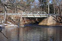
Weymouth Road Bridge | |
| Motto: "New Jersey's Largest Municipality" | |
 Map of Hamilton Township in Atlantic County. Inset: Location of Atlantic County highlighted in the State of New Jersey. | |
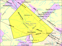 Census Bureau map of Hamilton Township, Atlantic County, New Jersey | |
| Coordinates: 39°28′55″N 74°44′15″W / 39.481949°N 74.737379°WCoordinates: 39°28′55″N 74°44′15″W / 39.481949°N 74.737379°W[1][2] | |
| Country |
|
| State |
|
| County | Atlantic |
| Incorporated | February 5, 1813 |
| Named for | Alexander Hamilton |
| Government[3] | |
| • Type | Township |
| • Body | Township Committee |
| • Mayor | Roger J. Silva (term ends December 31, 2016)[4][5] |
| • Clerk | Joan I. Anderson[6] |
| Area[1] | |
| • Total | 113.066 sq mi (292.841 km2) |
| • Land | 111.127 sq mi (287.818 km2) |
| • Water | 1.939 sq mi (5.023 km2) 1.72% |
| Area rank |
2nd of 566 in state 2nd of 23 in county[1] |
| Elevation[7] | 30 ft (9 m) |
| Population (2010 Census)[8][9][10] | |
| • Total | 26,503 |
| • Estimate (2015)[11] | 26,787 |
| • Rank |
92nd of 566 in state 4th of 23 in county[12] |
| • Density | 238.5/sq mi (92.1/km2) |
| • Density rank |
494th of 566 in state 16th of 23 in county[12] |
| Time zone | Eastern (EST) (UTC-5) |
| • Summer (DST) | Eastern (EDT) (UTC-4) |
| ZIP Code | 08330 - Mays Landing[13][14] |
| Area code(s) | 609[15] |
| FIPS code | 3400129280[1][16][17] |
| GNIS feature ID | 0882049[1][18] |
| Website |
www |
Hamilton Township is a township in Atlantic County, New Jersey, United States. As of the 2010 United States Census, the township's population was 26,503,[8][9][10] reflecting an increase of 6,004 (+29.3%) from the 20,499 counted in the 2000 Census, which had in turn increased by 4,487 (+28.0%) from the 16,012 counted in the 1990 Census.[19] The Township of Hamilton was incorporated by the New Jersey Legislature on February 5, 1813.[20][21]
The township calls itself "New Jersey's Largest Municipality" on its stationery and its website. At 111.127 square miles (287.82 km2), Hamilton Township has the largest land area of any municipality in New Jersey.[22] However, with a total area of 113.066 square miles (292.84 km2) it is the second-largest municipality in New Jersey in terms of total area; neighboring Galloway Township, which has a total area of 115.213 square miles (298.40 km2), is more than 2.1 square miles (5.4 km2) larger than Hamilton Township.[1][23]
History
Hamilton Township's origins are directly tied to the Great Egg Harbor River and its tributaries which run through it. George May, after whom the village of Mays Landing was named, built a shipyard and trading post near Babcock Creek in 1756. By the mid 19th century, Mays Landing reached the height of its shipbuilding.
From 1830 to 1880, more than 200 vessels were built along the Great Egg Harbor River with lumber from native forests and iron from Weymouth foundries. Half of them were produced at Mays Landing. But by the end of century, wood shipbuilding began to disappear due to the lack of suitable timber. Iron was then substituted for hull construction.
Hamilton was incorporated as a township by an act of the New Jersey Legislature on February 5, 1813, from portions of Egg Harbor Township and Weymouth Township, while the area was still part of Gloucester County. Hamilton became part of the newly created Atlantic County in 1837. Portions of the township were taken to form Hammonton on March 5, 1866, and to form Buena Vista Township on March 5, 1867.[21] The township was named for Alexander Hamilton.[24]
Geography
According to the United States Census Bureau, the township had a total area of 113.066 square miles (292.841 km2), including 111.127 square miles (287.818 km2) of land and 1.939 square miles (5.023 km2) of water (1.72%).[1][2]
Mays Landing (with a Census 2010 population of 2,135[25]) is a census-designated place located within Hamilton Township[1][20][26] that has been the county seat of Atlantic County since 1837.[27][28]
Other unincorporated communities, localities and place names located partially or completely within the township include Mays Landing, the county seat of Atlantic County, as well as Bears Head, Carmantown, Catawba, Clarktown, Cologne, Dacosta, Emmelsville, Gravelly Run, Lake Lenape, Laureldale, McKee City, Mizpah, Reega, Thompsontown, Weymouth and Wilsons Landing.[29][30]
Pinelands Reserve
The township is one of 56 South Jersey municipalities that are included within the New Jersey Pinelands National Reserve, a protected natural area of unique ecology covering 1,100,000 acres (450,000 ha), that has been classified as a United States Biosphere Reserve and established by Congress in 1978 as the nation's first National Reserve.[31] Part of the township is included in the state-designated Pinelands Area, which includes portions of Atlantic County, along with areas in Burlington, Camden, Cape May, Cumberland, Gloucester and Ocean counties.[32]
The western three-quarters of the township is governed by regulation by the New Jersey Pinelands Commission, which places major limitations on development in that portion of the township, which remains as pine forest with a distinctly rural character, with other portions designated as a Rural Development Area.[33] Significant portions of the eastern quarter of the township are designated by the Pinelands Commission as part of the Regional Growth Area (RGA), in which development is "allowed and encouraged" in the area surrounding Atlantic City, New Jersey.[34] The majority of the township's residents live in the area covered by the RGA, which has been developed in suburban fashion and includes shopping areas such as the Hamilton Mall, part of the township's 3,000,000 square feet (280,000 m2) of first class commercial retail properties.[20][35]
Demographics
| Historical population | |||
|---|---|---|---|
| Census | Pop. | %± | |
| 1820 | 877 | — | |
| 1830 | 1,424 | 62.4% | |
| 1840 | 1,565 | 9.9% | |
| 1850 | 2,015 | 28.8% | |
| 1860 | 1,945 | −3.5% | |
| 1870 | 1,271 | * | −34.7% |
| 1880 | 1,464 | 15.2% | |
| 1890 | 1,512 | 3.3% | |
| 1900 | 1,682 | 11.2% | |
| 1910 | 2,271 | 35.0% | |
| 1920 | 2,406 | 5.9% | |
| 1930 | 3,193 | 32.7% | |
| 1940 | 3,363 | 5.3% | |
| 1950 | 3,774 | 12.2% | |
| 1960 | 6,017 | 59.4% | |
| 1970 | 6,445 | 7.1% | |
| 1980 | 9,499 | 47.4% | |
| 1990 | 16,012 | 68.6% | |
| 2000 | 20,499 | 28.0% | |
| 2010 | 26,503 | 29.3% | |
| Est. 2015 | 26,787 | [11][36] | 1.1% |
| Population sources: 1820-1920[37] 1820-1830[38] 1840-2000[39] 1840[40] 1850-1870[41] 1850[42] 1870[43] 1880-1890[44] 1890-1910[45] 1910-1930[46] 1930-1990[47] 2000[48][49] 2010[8][9][10] * = Lost territory in previous decade.[21] | |||
2010 Census
At the 2010 United States Census, there were 26,503 people, 9,490 households, and 6,690 families residing in the township. The population density was 238.5 per square mile (92.1/km2). There were 10,196 housing units at an average density of 91.8 per square mile (35.4/km2). The racial makeup of the township was 67.96% (18,011) White, 18.55% (4,916) Black or African American, 0.26% (68) Native American, 5.41% (1,435) Asian, 0.06% (16) Pacific Islander, 4.12% (1,092) from other races, and 3.64% (965) from two or more races. Hispanics or Latinos of any race were 12.79% (3,390) of the population.[8]
There were 9,490 households, of which 32.7% had children under the age of 18 living with them, 48.1% were married couples living together, 16.7% had a female householder with no husband present, and 29.5% were non-families. 22.7% of all households were made up of individuals, and 6.1% had someone living alone who was 65 years of age or older. The average household size was 2.67 and the average family size was 3.15.[8]
In the township, 24.1% of the population were under the age of 18, 9.3% from 18 to 24, 28.5% from 25 to 44, 27.6% from 45 to 64, and 10.5% who were 65 years of age or older. The median age was 37.1 years. For every 100 females there were 98.3 males. For every 100 females age 18 and over, there were 96.0 males.[8]
The Census Bureau's 2006-2010 American Community Survey showed that (in 2010 inflation-adjusted dollars) median household income was $59,085 (with a margin of error of +/- $3,242) and the median family income was $62,354 (+/- $3,893). Males had a median income of $47,110 (+/- $4,411) versus $36,615 (+/- $3,549) for females. The per capita income for the borough was $25,292 (+/- $1,528). About 8.4% of families and 10.2% of the population were below the poverty line, including 13.1% of those under age 18 and 9.2% of those age 65 or over.[50]
2000 Census
As of the 2000 United States Census[16] there were 20,499 people, 7,148 households, and 5,039 families residing in the township. The population density was 184.2 people per square mile (71.1/km²). There were 7,567 housing units at an average density of 68.0 per square mile (26.3/km²). The racial makeup of the township was 71.45% White, 19.26% African American, 0.29% Native American, 3.29% Asian, 0.05% Pacific Islander, 3.33% from other races, and 2.33% from two or more races. Hispanic or Latino of any race were 7.91% of the population.[48][49]
There were 7,148 households out of which 37.3% had children under the age of 18 living with them, 50.5% were married couples living together, 15.0% had a female householder with no husband present, and 29.5% were non-families. 22.2% of all households were made up of individuals and 5.6% had someone living alone who was 65 years of age or older. The average household size was 2.72 and the average family size was 3.21.[48][49]
In the township the population was spread out with 27.1% under the age of 18, 8.2% from 18 to 24, 35.9% from 25 to 44, 20.7% from 45 to 64, and 8.2% who were 65 years of age or older. The median age was 34 years. For every 100 females there were 99.4 males. For every 100 females age 18 and over, there were 97.7 males.[48][49]
The median income for a household in the township was $50,259, and the median income for a family was $54,899. Males had a median income of $37,419 versus $30,089 for females. The per capita income for the township was $21,309. About 4.5% of families and 6.6% of the population were below the poverty line, including 9.1% of those under age 18 and 6.6% of those age 65 or over.[48][49]
Economy
Hamilton is home to over 3,000,000 square feet (280,000 m2) of first-class retail establishments including Hamilton Mall, Consumer Square and Hamilton Commons.
Balic Winery, established in 1966, produces 27 different wines on a 57-acre (23 ha) vineyard.[51]
Parks and recreation
The Great Egg Harbor River and Lake Lenape are recreational resources used by local residents and visitors alike. Hamilton is also home to the Atlantic County Justice Facility, the County Court Complex and the main branch of the Atlantic County Library.
Government
Local government
The Township of Hamilton is governed under the Township form of New Jersey municipal government. The five-member Township Committee is elected directly by the voters at-large in partisan elections to serve three-year terms of office on a staggered basis, with either one or two seats coming up for election each year as part of the November general election in a three-year cycle.[3][52] At an annual reorganization meeting each January, the Council selects one of its members to serve as Mayor and another as Deputy Mayor.
As of 2016, the members of the Hamilton Township Committee are Mayor Roger J. Silva (R, term on committee and as mayor ends December 31, 2016), Deputy Mayor Amy L. Gatto (R, term on committee and as deputy mayor ends 2016), Rodney C. Guishard (D, 2018), John Kurtz (R, 2017) and Arthur J. Schenker (R, 2018).[4][53][54][55][56][57]
Federal, state and county representation
Hamilton Township is located in the 2nd Congressional District[58] and is part of New Jersey's 2nd state legislative district.[9][59][60]
New Jersey's Second Congressional District is represented by Frank LoBiondo (R, Ventnor City).[61] New Jersey is represented in the United States Senate by Cory Booker (D, Newark, term ends 2021)[62] and Bob Menendez (D, Paramus, 2019).[63][64]
For the 2016–2017 session (Senate, General Assembly), the 2nd Legislative District of the New Jersey Legislature is represented in the State Senate by Jim Whelan (D, Atlantic City) and in the General Assembly by Chris A. Brown (R, Ventnor City) and Vince Mazzeo (D, Northfield).[65] The Governor of New Jersey is Chris Christie (R, Mendham Township).[66] The Lieutenant Governor of New Jersey is Kim Guadagno (R, Monmouth Beach).[67]
Atlantic County is governed by a directly elected executive and a nine-member Board of Chosen Freeholders, responsible for legislation. The executive serves a four-year term and the freeholders are elected to staggered three-year terms, of which four are elected from the county on an at-large basis and five of the freeholders represent equally populated districts.[68][69] As of 2015, Atlantic County's Executive is Republican Dennis Levinson, whose term of office ends December 31, 2015.[70] Members of the Board of Chosen Freeholders are Chairman Frank D. Formica, Freeholder District 2, including Atlantic City (part), Egg Harbor Township (part), Linwood, Longport, Margate, Northfield, Somers Point and Ventnor (R, 2015),[71] Vice Chairman James A. Bertino, Freeholder District 5, including Buena Borough, Buena Vista Township, Corbin City, Egg Harbor City, Estell Manor, Folsom, Hamilton Township (part), Hammonton, Mullica Township and Weymouth (R, 2015),[72] Colin G. Bell, Freeholder At-Large (R, 2015),[73] John Carman, Freeholder District 3, including Egg Harbor Township (part) and Hamilton Township (part) (R, 2017),[74] Ernest D. Coursey, Freeholder District 1, including Atlantic City (part), Egg Harbor Township (part) and Pleasantville (R, 2016),[75] Richard Dase, Freeholder District 4, including Absecon, Brigantine, Galloway Township and Port Republic (D, 2016),[76] Alexander C. Marino, Freeholder At-Large (R, 2017),[77] Will Pauls, Freeholder At-Large (R, 2016)[78] and John W. Risley, Freeholder At-Large (R, 2017).[79][80][81] Constitutional officers are County Clerk Edward P. McGettigan (2016),[82] Sheriff Frank X. Balles (R, 2017)[83] and Surrogate James Curcio (2015).[84][85]
Politics
As of March 23, 2011, there were a total of 15,486 registered voters in Hamilton Township, of which 4,305 (27.8% vs. 30.5% countywide) were registered as Democrats, 3,541 (22.9% vs. 25.2%) were registered as Republicans and 7,635 (49.3% vs. 44.3%) were registered as Unaffiliated. There were 5 voters registered to other parties.[86] Among the township's 2010 Census population, 58.4% (vs. 58.8% in Atlantic County) were registered to vote, including 76.9% of those ages 18 and over (vs. 76.6% countywide).[86][87]
In the 2012 presidential election, Democrat Barack Obama received 6,748 votes here (59.9% vs. 57.9% countywide), ahead of Republican Mitt Romney with 4,334 votes (38.5% vs. 41.1%) and other candidates with 130 votes (1.2% vs. 0.9%), among the 11,268 ballots cast by the township's 16,710 registered voters, for a turnout of 67.4% (vs. 65.8% in Atlantic County).[88][89] In the 2008 presidential election, Democrat Barack Obama received 6,619 votes here (57.7% vs. 56.5% countywide), ahead of Republican John McCain with 4,612 votes (40.2% vs. 41.6%) and other candidates with 148 votes (1.3% vs. 1.1%), among the 11,481 ballots cast by the township's 16,199 registered voters, for a turnout of 70.9% (vs. 68.1% in Atlantic County).[90] In the 2004 presidential election, Democrat John Kerry received 5,055 votes here (51.9% vs. 52.0% countywide), ahead of Republican George W. Bush with 4,507 votes (46.2% vs. 46.2%) and other candidates with 83 votes (0.9% vs. 0.8%), among the 9,747 ballots cast by the township's 13,128 registered voters, for a turnout of 74.2% (vs. 69.8% in the whole county).[91]
In the 2013 gubernatorial election, Republican Chris Christie received 4,086 votes here (59.0% vs. 60.0% countywide), ahead of Democrat Barbara Buono with 2,526 votes (36.5% vs. 34.9%) and other candidates with 127 votes (1.8% vs. 1.3%), among the 6,924 ballots cast by the township's 17,080 registered voters, yielding a 40.5% turnout (vs. 41.5% in the county).[92][93] In the 2009 gubernatorial election, Republican Chris Christie received 3,346 votes here (47.9% vs. 47.7% countywide), ahead of Democrat Jon Corzine with 3,102 votes (44.4% vs. 44.5%), Independent Chris Daggett with 386 votes (5.5% vs. 4.8%) and other candidates with 93 votes (1.3% vs. 1.2%), among the 6,983 ballots cast by the township's 15,764 registered voters, yielding a 44.3% turnout (vs. 44.9% in the county).[94]
Education
For pre-Kindergarten through eighth grade, public school students attend the Hamilton Township Schools. As of the 2011-12 school year, the district's three schools had an enrollment of 3,156 students and 259.5 classroom teachers (on an FTE basis), for a student–teacher ratio of 12.16:1.[95] Schools in the district (with 2011-12 enrollment data from the National Center for Education Statistics[96]) are Joseph C. Shaner Memorial School[97] with 621 students in Pre-K to 1st grade, George Hess Educational Complex[98] with 1,529 in grades 2 - 5 and William Davies Middle School[99] with 1,006 students in grades 6 - 8.[100]
Public school students in ninth through twelfth grades attend Oakcrest High School, located in Hamilton Township, which serves students from Hamilton Township.[101] The high school is part of the Greater Egg Harbor Regional High School District, a regional publichigh school district serving students at the district's two other schools, Absegami High School and Cedar Creek High School, from the other constituent districts of Egg Harbor City, Galloway Township and Mullica Township, together with students from the City of Port Republic and Washington Township (in Burlington County), who attend as part of sending/receiving relationships with their respective school districts.[102]
The Atlantic County Institute of Technology, established in 1974 and located on a campus covering 58 acres (23 ha), provides vocational instruction to high school students and adults from across Atlantic County, and was one of eight schools in the state recognized in 2008 as a National Blue Ribbon School by the United States Department of Education.[103] Township public school students are also eligible to attend Charter-Tech High School for the Performing Arts, located in Somers Point.[104]
Saint Vincent de Paul Regional School is a Catholic elementary school in Mays Landing, serving students in pre-Kindergarten through eighth grade since 1961 and operated under the jurisdiction of the Diocese of Camden.[105][106]
Atlantic Cape Community College was the second community college to be established in New Jersey, and moved to its campus in Mays Landing in February 1968 where it now serves students from both Atlantic County and Cape May County.[107]
Transportation
As of May 2010, the township had a total of 258.55 miles (416.10 km) of roadways, of which 171.15 miles (275.44 km) were maintained by the municipality, 40.49 miles (65.16 km) by Atlantic County, 32.91 miles (52.96 km) by the New Jersey Department of Transportation and 14.00 miles (22.53 km) by the South Jersey Transportation Authority.[108]
A variety of roads pass through the township. Hamilton hosts a 14-mile (23 km) stretch of the Atlantic City Expressway with three interchanges and the Egg Harbor Tolls. U.S. Route 40, U.S. Route 322 pass through as well as Route 50. The major county roads include County Route 552, County Route 559, County Route 563 and County Route 575.
Public transportation
NJ Transit provides bus service in the township between Cape May and Philadelphia on the 315 route and to Atlantic City on routes 502 from Atlantic Cape Community College and 553 from Upper Deerfield Township.[109][110]
Notable people
People who were born in, residents of, or otherwise closely associated with Hamilton Township include:
- Brandon Bell (born 1995), linebacker for the Penn State Nittany Lions football team.[111]
- Cory Bird (born 1978), safety who played for the Indianapolis Colts.[112]
- Ilsley Boone (1879–1968), established and ran the national headquarters of the American Sunbathing Association (ASA) at Sunshine Park (which operated from 1931 to 1983) in Mays Landing.[113]
- Suzette Charles (born 1963), singer and entertainer, who became Miss America 1984.[114]
- Darren Drozdov (born 1969), ex-NFL player and retired professional wrestler who competed in the WWF.[115]
- Mae Faggs (1932-2000), track-and-field athlete who was a gold medalist in the Women's 4 × 100 meters relay at 1952 Summer Olympics.[116]
- Harvey Kesselman (born 1951), fifth president of Stockton University.[117]
- Walter Lowenfels (1897-1976), poet, journalist, and member of the Communist Party USA who edited the communist newspaper the Daily Worker.[118]
- Shea McKeen (born 1986), professional football player defensive lineman.[119]
- William Moore (1810–1878), served in the United States House of Representatives, where he represented New Jersey's 1st congressional district from 1867 to 1871.[120]
- Sharon Kay Penman (born 1945), historical novelist.[121]
- Graciela Rivera (1921-2011), first Puerto Rican to sing a lead role at the Metropolitan Opera in New York.[122]
References
- 1 2 3 4 5 6 7 8 2010 Census Gazetteer Files: New Jersey County Subdivisions, United States Census Bureau. Accessed May 21, 2015.
- 1 2 US Gazetteer files: 2010, 2000, and 1990, United States Census Bureau. Accessed September 4, 2014.
- 1 2 2012 New Jersey Legislative District Data Book, Rutgers University Edward J. Bloustein School of Planning and Public Policy, March 2013, p. 13.
- 1 2 Governing Body, Township of Hamilton. Accessed June 14, 2016.
- ↑ 2016 New Jersey Mayors Directory, New Jersey Department of Community Affairs. Accessed June 14, 2016.
- ↑ Municipal Governments in Atlantic County, Atlantic County, New Jersey. Accessed June 28, 2012.
- ↑ U.S. Geological Survey Geographic Names Information System: Township of Hamilton, Geographic Names Information System. Accessed March 5, 2013.
- 1 2 3 4 5 6 DP-1 - Profile of General Population and Housing Characteristics: 2010 for Hamilton township, Atlantic County, New Jersey, United States Census Bureau. Accessed December 11, 2011.
- 1 2 3 4 Municipalities Grouped by 2011-2020 Legislative Districts, New Jersey Department of State, p. 2. Accessed January 6, 2013.
- 1 2 3 Table DP-1. Profile of General Demographic Characteristics: 2010 for Hamilton township, New Jersey Department of Labor and Workforce Development. Accessed December 11, 2011.
- 1 2 PEPANNRES - Annual Estimates of the Resident Population: April 1, 2010 to July 1, 2015 - 2015 Population Estimates for New Jersey municipalities, United States Census Bureau. Accessed May 22, 2016.
- 1 2 GCT-PH1 Population, Housing Units, Area, and Density: 2010 - State -- County Subdivision from the 2010 Census Summary File 1 for New Jersey, United States Census Bureau. Accessed September 19, 2012.
- ↑ Look Up a ZIP Code for Mays Landing, NJ, United States Postal Service. Accessed April 24, 2012.
- ↑ Zip Codes, State of New Jersey. Accessed September 10, 2013.
- ↑ Area Code Lookup - NPA NXX for Mays Landing, NJ, Area-Codes.com. Accessed September 10, 2013.
- 1 2 American FactFinder, United States Census Bureau. Accessed September 4, 2014.
- ↑ A Cure for the Common Codes: New Jersey, Missouri Census Data Center. Accessed June 28, 2012.
- ↑ US Board on Geographic Names, United States Geological Survey. Accessed September 4, 2014.
- ↑ Table 7. Population for the Counties and Municipalities in New Jersey: 1990, 2000 and 2010, New Jersey Department of Labor and Workforce Development, February 2011. Accessed June 28, 2012.
- 1 2 3 A Brief Overview of our Town, Hamilton Township. Accessed October 2, 2006.
- 1 2 3 Snyder, John P. The Story of New Jersey's Civil Boundaries: 1606-1968, Bureau of Geology and Topography; Trenton, New Jersey; 1969. p. 69. Accessed April 24, 2012.
- ↑ New Jersey: Basic Information, United States Census Bureau. Accessed April 24, 2012.
- ↑ Barlas, Thomas. "Step aside, Hamilton twp.: Galloway is bigger / 'Largest' N.J. town a little smaller than neighbor, data show", The Press of Atlantic City, July 9, 2007. Accessed November 18, 2013. "Take Atlantic County's Hamilton Township, which for years has hailed itself on stationary and signs as "New Jersey's Largest Municipality.... But Hamilton Township residents might want to take another look at the numbers before becoming too smug with its bigness: The federal government says neighboring Galloway Township is actually larger."
- ↑ Hutchinson, Viola L. The Origin of New Jersey Place Names, New Jersey Public Library Commission, May 1945. Accessed August 31, 2015.
- ↑ DP-1 - Profile of General Population and Housing Characteristics: 2010 Demographic Profile Data for Mays Landing CDP, New Jersey, United States Census Bureau. Accessed June 28, 2012
- ↑ GCT-PH1 - Population, Housing Units, Area, and Density: 2010 - County -- County Subdivision and Place from the 2010 Census Summary File 1 for Atlantic County, New Jersey, United States Census Bureau. Accessed August 12, 2012.
- ↑ "Find a County". National Association of Counties. Retrieved 2011-06-07.
- ↑ Atlantic County, NJ, National Association of Counties. Accessed January 20, 2013.
- ↑ Township of Hamilton Historical Society. Township of Hamilton, Atlantic County, p. 7. Arcadia Publishing, 2001. ISBN 0-7385-0942-6. Accessed December 11, 2011.
- ↑ Locality Search, State of New Jersey. Accessed November 28, 2014.
- ↑ The Pinelands National Reserve, New Jersey Pinelands Commission. Accessed November 18, 2013.
- ↑ Pinelands Municipalities, New Jersey Pinelands Commission, April 2003. Accessed November 18, 2013.
- ↑ New Jersey Pinelands Land Capability Map, New Jersey Pinelands Commission, June 2011. Accessed December 11, 2011.
- ↑ Comprehensive Management Plan, New Jersey Pinelands Commission. Accessed December 11, 2011.
- ↑ Map of Hamilton Township, Atlantic County, New Jersey. Accessed December 11, 2011.
- ↑ Census Estimates for New Jersey April 1, 2010 to July 1, 2015, United States Census Bureau. Accessed May 22, 2016.
- ↑ Compendium of censuses 1726-1905: together with the tabulated returns of 1905, New Jersey Department of State, 1906. Accessed July 11, 2013.
- ↑ Barnett, Bob. Population Data for Gloucester County Municipalities, 1800 - 2000, WestJersey.org. December 6, 2010. Accessed November 28, 2013.
- ↑ Barnett, Bob. Population Data for Atlantic County Municipalities, 1840 - 2000, WestJersey.org. December 6, 2010. Accessed June 28, 2012.
- ↑ Bowen, Francis. American Almanac and Repository of Useful Knowledge for the Year 1843, p. 232, David H. Williams, 1842. Accessed September 10, 2013.
- ↑ Raum, John O. The History of New Jersey: From Its Earliest Settlement to the Present Time, Volume 1, p. 273, J. E. Potter and company, 1877. Accessed September 10, 2013. "Hamilton township in 1860 contained a population of 1,945; and in 1870, 1,271. Mays Landing the capital of the county, is in this township, at the head of navigation on Great Egg Harbor river, about sixty five miles south of Trenton. It consists of two parts, Mays Landing proper, and Hamilton, about a quarter of a mile up the river, where a dam has been constructed affording fine water power." Note that no population is lised for 1850.
- ↑ Debow, James Dunwoody Brownson. The Seventh Census of the United States: 1850, p. 137. R. Armstrong, 1853. Accessed September 10, 2013. Note that Hamilton is not listed, but that Hammonton is listed with a population of 2,015, despite the fact that the municipality was not incorporated until 1866.
- ↑ Staff. A compendium of the ninth census, 1870, p. 259. United States Census Bureau, 1872. Accessed September 10, 2013.
- ↑ Porter, Robert Percival. Preliminary Results as Contained in the Eleventh Census Bulletins: Volume III - 51 to 75, p. 97. United States Census Bureau, 1890. Accessed September 10, 2013.
- ↑ Thirteenth Census of the United States, 1910: Population by Counties and Minor Civil Divisions, 1910, 1900, 1890, United States Census Bureau, p. 335. Accessed June 28, 2012.
- ↑ Fifteenth Census of the United States: 1930 - Population Volume I, United States Census Bureau, p. 714. Accessed June 28, 2012.
- ↑ Table 6. New Jersey Resident Population by Municipality: 1930 - 1990, New Jersey Department of Labor and Workforce Development. Accessed June 28, 2015.
- 1 2 3 4 5 Census 2000 Profiles of Demographic / Social / Economic / Housing Characteristics for Hamilton township, Atlantic County, New Jersey, United States Census Bureau. Accessed June 28, 2012.
- 1 2 3 4 5 DP-1: Profile of General Demographic Characteristics: 2000 - Census 2000 Summary File 1 (SF 1) 100-Percent Data for Hamilton township, Atlantic County, New Jersey, United States Census Bureau. Accessed September 19, 2012.
- ↑ DP03: Selected Economic Characteristics from the 2006-2010 American Community Survey 5-Year Estimates for Hamilton township, Atlantic County, New Jersey, United States Census Bureau. Accessed June 28, 2012.
- ↑ About Balic, Balic Winery. Accessed May 28, 2015.
- ↑ "Forms of Municipal Government in New Jersey", p. 7. Rutgers University Center for Government Studies. Accessed June 3, 2015.
- ↑ 2016 Municipal User Friendly Budget, Township of Hamilton. Accessed June 14, 2016.
- ↑ Municipal Governments in Atlantic County, Atlantic County, New Jersey, updated June 2, 2016. Accessed June 14, 2016.
- ↑ General Election November 3, 2015 Official Results, Atlantic County, New Jersey Clerk. Accessed June 14, 2016.
- ↑ General Election Results - November 4, 2014 Official Results, Atlantic County, New Jersey Clerk. Accessed June 14, 2016.
- ↑ General Election November 5, 2013 Official Results, Atlantic County, New Jersey Clerk. Accessed June 14, 2016.
- ↑ Plan Components Report, New Jersey Redistricting Commission, December 23, 2011. Accessed January 6, 2013.
- ↑ 2016 New Jersey Citizen's Guide to Government, p. 58, New Jersey League of Women Voters. Accessed July 20, 2016.
- ↑ Districts by Number for 2011-2020, New Jersey Legislature. Accessed January 6, 2013.
- ↑ Directory of Representatives: New Jersey, United States House of Representatives. Accessed January 5, 2012.
- ↑ About Cory Booker, United States Senate. Accessed January 26, 2015. "He now owns a home and lives in Newark's Central Ward community."
- ↑ Biography of Bob Menendez, United States Senate, January 26, 2015. "He currently lives in Paramus and has two children, Alicia and Robert."
- ↑ Senators of the 114th Congress from New Jersey. United States Senate. Accessed January 26, 2015. "Booker, Cory A. - (D - NJ) Class II; Menendez, Robert - (D - NJ) Class I"
- ↑ Legislative Roster 2016-2017 Session, New Jersey Legislature. Accessed January 17, 2016.
- ↑ "About the Governor". State of New Jersey. Retrieved 2010-01-21.
- ↑ "About the Lieutenant Governor". State of New Jersey. Retrieved 2010-01-21.
- ↑ 2013 Atlantic County District Map, Atlantic County, New Jersey. Accessed March 7, 2015.
- ↑ Board of Chosen Freeholders, Atlantic County, New Jersey. Accessed March 7, 2015.
- ↑ County Executive, Atlantic County, New Jersey. Accessed March 7, 2015.
- ↑ Frank D. Formica, Atlantic County, New Jersey. Accessed March 7, 2015.
- ↑ James A. Bertino, Atlantic County, New Jersey. Accessed March 7, 2015.
- ↑ Colin G. Bell, Atlantic County, New Jersey. Accessed March 7, 2015.
- ↑ John Carman, Atlantic County, New Jersey. Accessed March 7, 2015.
- ↑ Ernest D. Coursey, Atlantic County, New Jersey. Accessed March 7, 2015.
- ↑ Richard Dase, Atlantic County, New Jersey. Accessed March 7, 2015.
- ↑ Alexander C. Marino, Atlantic County, New Jersey. Accessed March 7, 2015.
- ↑ Will Pauls, Atlantic County, New Jersey. Accessed March 7, 2015.
- ↑ John W. Risley, Atlantic County, New Jersey. Accessed March 7, 2015.
- ↑ Atlantic County Board of Chosen Freeholders, Atlantic County, New Jersey. Accessed March 7, 2015.
- ↑ 2014 Atlantic County Board of Chosen Freeholders, Atlantic County, New Jersey. Accessed March 7, 2015.
- ↑ Ed McGettigan, Atlantic County Clerk. Accessed March 7, 2015.
- ↑ Frank X. Balles, Sheriff, Atlantic County Sheriff's Office. Accessed March 7, 2015.
- ↑ Atlantic County Surrogate's Court, Atlantic County, New Jersey. Accessed March 7, 2015.
- ↑ Constitutional Officers, Atlantic County, New Jersey. Accessed March 7, 2015.
- 1 2 Voter Registration Summary - Atlantic, New Jersey Department of State Division of Elections, March 23, 2011. Accessed December 24, 2014.
- ↑ GCT-P7: Selected Age Groups: 2010 - State -- County Subdivision; 2010 Census Summary File 1 for New Jersey, United States Census Bureau. Accessed December 24, 2014.
- ↑ Presidential November 6, 2012 General Election Results - Atlantic County, New Jersey Department of State Division of Elections, March 15, 2013. Accessed December 24, 2014.
- ↑ Number of Registered Voters and Ballots Cast November 6, 2012 General Election Results - Atlantic County, New Jersey Department of State Division of Elections, March 15, 2013. Accessed December 24, 2014.
- ↑ 2008 Presidential General Election Results: Atlantic County, New Jersey Department of State Division of Elections, December 23, 2008. Accessed December 24, 2014.
- ↑ 2004 Presidential Election: Atlantic County, New Jersey Department of State Division of Elections, December 13, 2004. Accessed December 24, 2014.
- ↑ 2013 Governor: Atlantic County, New Jersey Department of State Division of Elections, January 29, 2014. Accessed December 24, 2014.
- ↑ Number of Registered Voters and Ballots Cast November 5, 2013 General Election Results : Atlantic County, New Jersey Department of State Division of Elections, January 29, 2014. Accessed December 24, 2014.
- ↑ 2009 Governor: Atlantic County, New Jersey Department of State Division of Elections, December 31, 2009. Accessed December 24, 2014.
- ↑ District information for Hamilton Township School District, National Center for Education Statistics. Accessed November 28, 2014.
- ↑ School Data for the Hamilton Township Schools, National Center for Education Statistics. Accessed November 28, 2014.
- ↑ Joseph C. Shaner Memorial School, Hamilton Township Schools. Accessed September 10, 2013.
- ↑ George Hess Educational Complex, Hamilton Township Schools. Accessed September 10, 2013.
- ↑ William Davies Middle School, Hamilton Township Schools. Accessed September 10, 2013.
- ↑ New Jersey School Directory for the Hamilton Township Schools, New Jersey Department of Education. Accessed September 9, 2013.
- ↑ Oakcrest High School 2013 Report Card Narrative, New Jersey Department of Education. Accessed June 14, 2016. "Oakcrest High School is entering its 53rd school year of academic excellence. Oakcrest is a comprehensive high school located in Mays Landing that provides a secondary school education to Hamilton Township."
- ↑ Greater Egg Harbor Regional School District 2015 Report Card Narrative, New Jersey Department of Education. Accessed June 5, 2016. "The Greater Egg Harbor Regional High School District serves the communities of Galloway Township, Hamilton Township, Egg Harbor City, Mullica Township and participates in receiving relationships with Port Republic and Washington Township. The geographic area of the district is the largest in the state, covering 324 square miles. The student body of each of the district's three comprehensive high schools, Absegami High School, Cedar Creek High School, and Oakcrest High School, reflects the socioeconomic and ethnic diversity of this geographic area."
- ↑ Mission / History, Atlantic County Institute of Technology. Accessed September 19, 2012.
- ↑ Profile, Charter-Tech High School for the Performing Arts. Accessed November 18, 2013.
- ↑ Brochure, Saint Vincent de Paul Regional School. Accessed September 10, 2013.
- ↑ Catholic Schools Directory, Roman Catholic Diocese of Camden. Accessed October 20, 2016.
- ↑ History, Atlantic Cape Community College. Accessed September 19, 2012.
- ↑ Atlantic County Mileage by Municipality and Jurisdiction, New Jersey Department of Transportation, May 2010. Accessed November 18, 2013.
- ↑ Atlantic County Bus / Rail Connections, NJ Transit, backed up by the Internet Archive as of July 26, 2010. Accessed November 18, 2013.
- ↑ South Jersey Transit Guide, Cross County Connection, as of April 1, 2010. Accessed November 18, 2013.
- ↑ James, Michael. "Oakcrest graduate Brandon Bell named captain at Penn State", The Press of Atlantic City, August 24, 2016. Accessed October 25, 2016. "Oakcrest High School graduate and Penn State University linebacker Brandon Bell was named defensive captain Tuesday for the Nittany Lions' upcoming season. Bell is a senior from Mays Landing who graduated from Oakcrest in 2013 and was a Press first-team All-Star."
- ↑ LeConey, Bill. "FOOTBALL / HOKIES' BIRD INJURED IN LOSS", The Press of Atlantic City, January 5, 2000. Accessed September 20, 2012. "Bird, a junior from Mays Landing, finished with three tackles, one for a loss."
- ↑ Barlas, Thomas. "Hamilton to get $300,000 with sale of former nudist colony site", The Press of Atlantic City, July 30, 2009. Accessed September 20, 2012. "Sunshine Park and the township have been connected financially for years. The nudist colony was founded in 1931 as a health resort by Ilsey Boone, a minister-educator who was struck by the then-new 'nudism fever.'"
- ↑ Chira, Susan. "TO FIRST BLACK MISS AMERICA, VICTORY IS A MEANS TO AN END", The New York Times, September 19, 1983. Accessed April 24, 2012. "Her home is in Mays Landing, 15 miles west of Atlantic City, the site of the contest."
- ↑ Darren Drozdov, database Football. Accessed December 8, 2007.
- ↑ Goldstein, Richard. "Mae Faggs Starr, Champion And Track Mentor, Dies at 67", The New York Times, February 11, 2000. Accessed January 26, 2016. "Aeriwentha Mae Faggs was born in Mays Landing, N.J., but grew up in New York City."
- ↑ Landau, Joel. "Hamilton Township Committeeman Harvey Kesselman won't run again in 2012", The Press of Atlantic City, November 9, 2011. Accessed November 7, 2015. "The 2012 election season already has begun in Hamilton Township. Township Committeeman Harvey Kesselman announced Wednesday he will not seek re-election when his term expires next year.... Kesselman said he felt he did not have enough time to serve on the body, noting his job as provost of The Richard Stockton College of New Jersey in Galloway Township."
- ↑ Finding-aid for the Walter Lowenfels Papers (MSS074), Washington University in St. Louis. Accessed November 18, 2013. "Walter Lowenfels, poet, editor, translator, was born in New York, is married to the former Lillian Apotheker, who has collaborated with him and with Nan Braymer in this and other anthologies of poetry. He lives now in Mays Landing, New York, from where his correspondence, and much of the business material of this anthology emanated, roughly from February, 1966 - Oct., 1967, shortly after which the anthology was published by Doubleday."
- ↑ Staff. "Lineman Arrested Following Bar Fight", The State (newspaper), March 25, 2006. Accessed November 18, 2013. "McKeen, a freshman from Mays Landing, N.J., was released Friday from the Richland County jail on a personal-recognizance bond, according to a jail spokesperson."
- ↑ William Moore, Biographical Directory of the United States Congress. Accessed August 24, 2007.
- ↑ Simpson, David. "Mays Landing author feels equally at home in Europe of Middle Ages", The Press of Atlantic City, October 26, 2011. Accessed September 20, 2012. "When Sharon Kay Penman, of Mays Landing, speaks of completing a novel, she sounds like one of her characters: a medieval warrior."
- ↑ Obituary. "GRACIELA RIVERA ZUMCHAK", The Press of Atlantic City, July 20, 2011. Accessed September 20, 2012. "ZUMCHAK, GRACIELA RIVERA 90 - of Mays Landing went home to be with her Lord and Savior on Sunday, July 17, 2011."
External links
- Township of Hamilton Official Site
- Mays Landing Merchants Association
- Hamilton Township Municipal Utilities Authority
- Hamilton Township Schools
- Hamilton Township Schools's 2014–15 School Report Card from the New Jersey Department of Education
- Data for the Hamilton Township Schools, National Center for Education Statistics
- Oakcrest High School website
- Greater Egg Harbor Regional High School District
- The Current of Hamilton Township
- Atlantic City Race Course website
- Hamilton Mall website
Municipalities and communities of Atlantic County, New Jersey, United States | ||
|---|---|---|
| Cities |  | |
| Boroughs | ||
| Town | ||
| Townships | ||
| CDPs | ||
| Other unincorporated communities | ||
 |
Folsom Hammonton |
Mullica | | |
| Buena Vista Township | |
Galloway Township | ||
| ||||
| | ||||
| Weymouth Township Estell Manor |
Egg Harbor Township |