Monroe Township, Howard County, Indiana
| Monroe Township | |
|---|---|
| Township | |
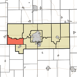 Location in Howard County | |
| Coordinates: 40°27′06″N 86°18′59″W / 40.45167°N 86.31639°WCoordinates: 40°27′06″N 86°18′59″W / 40.45167°N 86.31639°W | |
| Country | United States |
| State | Indiana |
| County | Howard |
| Government | |
| • Type | Indiana township |
| Area | |
| • Total | 19.2 sq mi (50 km2) |
| • Land | 19.2 sq mi (50 km2) |
| • Water | 0 sq mi (0 km2) 0% |
| Elevation | 810 ft (247 m) |
| Population (2010) | |
| • Total | 1,407 |
| • Estimate (2012[1]) | 1,412 |
| • Density | 73.3/sq mi (28.3/km2) |
| GNIS feature ID | 0453639 |
Monroe Township is one of eleven townships in Howard County, Indiana, United States. As of the 2010 census, its population was 1,407 and it contained 560 housing units.[2]
History
Monroe Township was established in 1837.[3]
Geography
| Historical population | |||
|---|---|---|---|
| Census | Pop. | %± | |
| 2000 | 1,387 | — | |
| 2010 | 1,407 | 1.4% | |
| Est. 2012 | 1,412 | 0.4% | |
| U.S. Census[4] | |||
According to the 2010 census, the township has a total area of 19.2 square miles (50 km2), all land.[2] The streams of Little Wildcat Creek, Walnut Fork and West Honey Creek run through this township. As the 1870 census, New London was an incorporated town with a population of 240 people, which at the time was much more than Russiaville (at 160). In the 1880 census New London is no longer shown as an incorporated town, whereas Greentown (in Liberty Township) was shown as being incorporated.[5]
Unincorporated communities
- New London
- Shanghai
(This list is based on USGS data and may include former settlements.)
Adjacent townships
- Ervin Township (north)
- Clay Township (northeast)
- Harrison Township (east)
- Honey Creek Township (southeast)
- Forest Township, Clinton County (south)
- Warren Township, Clinton County (southwest)
- Burlington Township, Carroll County (west)
Major highways
References
- ↑ "Population Estimates". United States Census Bureau. Retrieved 2013-06-25.
- 1 2 "Population, Housing Units, Area, and Density: 2010 - County -- County Subdivision and Place -- 2010 Census Summary File 1". United States Census. Retrieved 2013-05-10.
- ↑ "Howard County's Townships and Their Early Settlements and Towns". Kokomo-Howard County Public Library. Retrieved 2 June 2014.
- ↑ "US Census Data". US Government Census Agency. Retrieved 26 February 2014.
- ↑ "Census of Population and Housing". US Government/Census. Retrieved 1 March 2014.
External links
Municipalities and communities of Howard County, Indiana, United States | ||
|---|---|---|
| City | ||
| Towns | ||
| Townships | ||
| Other unincorporated communities |
| |