Howard Township, Howard County, Indiana
| Howard Township | |
|---|---|
| Township | |
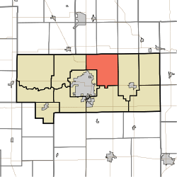 Location in Howard County | |
| Coordinates: 40°31′44″N 86°03′31″W / 40.52889°N 86.05861°WCoordinates: 40°31′44″N 86°03′31″W / 40.52889°N 86.05861°W | |
| Country | United States |
| State | Indiana |
| County | Howard |
| Government | |
| • Type | Indiana township |
| Area | |
| • Total | 30.05 sq mi (77.8 km2) |
| • Land | 29.65 sq mi (76.8 km2) |
| • Water | 0.4 sq mi (1 km2) 1.33% |
| Elevation | 820 ft (250 m) |
| Population (2010) | |
| • Total | 2,579 |
| • Estimate (2012[1]) | 2,583 |
| • Density | 87/sq mi (34/km2) |
| GNIS feature ID | 0453419 |
Howard Township is one of eleven townships in Howard County, Indiana, United States. As of the 2010 census, its population was 2,579 and it contained 1,072 housing units.[2]
| Historical population | |||
|---|---|---|---|
| Census | Pop. | %± | |
| 2000 | 2,866 | — | |
| 2010 | 2,579 | −10.0% | |
| Est. 2012 | 2,583 | 0.2% | |
| U.S. Census[3] | |||
History
Howard Township and Howard County are both named for Tilghman Howard, an Indiana congressman.[4]
Geography
According to the 2010 census, the township has a total area of 30.05 square miles (77.8 km2), of which 29.65 square miles (76.8 km2) (or 98.67%) is land and 0.4 square miles (1.0 km2) (or 1.33%) is water.[2]
Unincorporated towns
Adjacent townships
- Clay Township, Miami County (north)
- Harrison Township, Miami County (northeast)
- Liberty Township (east)
- Taylor Township (south)
- Center Township (southwest)
- Clay Township (west)
- Deer Creek Township, Miami County (northwest)
Cemeteries
The township contains three cemeteries: Hopewell, Hudson and Salem.
Major highways
Airports and landing strips
- Kokomo Municipal Airport
- Medallion Field
References
- "Howard Township, Howard County, Indiana". Geographic Names Information System. United States Geological Survey. Retrieved 2009-09-24.
- United States Census Bureau cartographic boundary files
- ↑ "Population Estimates". United States Census Bureau. Retrieved 2013-06-25.
- 1 2 "Population, Housing Units, Area, and Density: 2010 - County -- County Subdivision and Place -- 2010 Census Summary File 1". United States Census. Retrieved 2013-05-10.
- ↑ "US Census Data". US Government Census Agency. Retrieved 26 February 2014.
- ↑ "Howard County's Townships and Their Early Settlements and Towns". Kokomo-Howard County Public Library. Retrieved 2 June 2014.
External links
Municipalities and communities of Howard County, Indiana, United States | ||
|---|---|---|
| City | ||
| Towns | ||
| Townships | ||
| Other unincorporated communities |
| |
This article is issued from Wikipedia - version of the 4/26/2015. The text is available under the Creative Commons Attribution/Share Alike but additional terms may apply for the media files.