Mong Khet Township
| Mong Khet | |
|---|---|
| Township | |
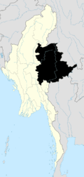
 Mong Khet Location in Burma | |
| Coordinates: 21°42′00″N 99°23′00″E / 21.70000°N 99.38333°ECoordinates: 21°42′00″N 99°23′00″E / 21.70000°N 99.38333°E | |
| Country |
|
| State | Shan State |
| District | Kengtong District |
| Elevation[1] | 1,022 m (3,353 ft) |
| Time zone | MST (UTC+6.30) |
Mong Khet Township[2] (also Mongkhat Township) is a township of Kengtong District in the Shan State of Burma. The principal town and administrative center is Mong Khet.
Communities
Among the many small towns and villages, in addition to the town of Mong Khet, the following communities are local centers: Wan Namtawnkang, Wan La, Wan Singpyin, Wan Hsi-hsaw, Wan Pang-yao, Wan Ho-hkü, Wan Kawnhawng, Wan Ho-nawng, and Ta-pom.
References
- ↑ GoogleEarth
- ↑ Township 220 on "Myanmar States/Divisions & Townships Overview Map" Myanmar Information Management Unit (MIMU), December 2007
External links
- "Mongkhak Google Satellite Map" Maplandia World Gazetteer
Capital: Mong Khet | |
|

This article is issued from Wikipedia - version of the 11/29/2015. The text is available under the Creative Commons Attribution/Share Alike but additional terms may apply for the media files.