Kutkai Township
| Kutkai | |
|---|---|
| Township | |
 Kutkai | |
| Coordinates: 23°27′0″N 97°55′0″E / 23.45000°N 97.91667°E | |
| Country |
|
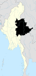
| State | Shan State |
| District | Mu Se District |
| Elevation[1] | 4,600 ft (1,400 m) |
| Time zone | MMT (UTC+6:30) |
Kutkai Township is a township of Muse District in the Shan State of eastern Burma. The principal town is Kutkai.[2]
Geography
It shares the border with Laukkai Township aka Laukkaing Township of Laukkaing District in the east.[3] It shares the borders with Muse Township in the north, Kunlong Township and Salween River in the east, Hsenwi Township in the south, Namhkam Township aka Nanhkan Township and Namtu Township in the west. it was formed with 6 wards, 75 village tracts and 640 villages on 15 July 1972. It has 16 wards, 69 village tracts and 463 villages in 2009. Its population is over 120,000 in 2009.[4]
It has rain from May to October and average rain fall of 70 inches in 119 days a year. Its attitude is over 4,400 feet above sea level and its temperature is not over 30 degree Celsius. It is 7.06 square miles.[5]
There are 4 high schools, 1 high school (branch), 5 middle schools, 3 middle schools (branch), 20 post-primary schools and 102 primary schools.
There are 2 hospitals of 25 bedded, 3 hospitals of 16 bedded, 7 rural health care centers, 35 rural health care centers (branch) and 2 station health care centers.
The No.4 Brigade of the Kachin Independence Army is active in the area.[6] Battalion 8 is near Nam Hpak Ka and Battalion 9 is near the Dak Nai, Kutkai.[7]
Economy
Major business is agriculture and livestock breeding. Paddy, corn, groundnut, sesame, sunflower, black gram, green gram, pigeon peas, cotton and sugarcane are grown. tea, walnut, coffee, rubber and tapioca are grown as poppy substitutes. It has 92,491 acres of arable lands. Paddy fields are about 16,882, other crops are 36,645 acres, hilly farmlands are 6,850 acres and gardens are 31,869 acres.
It has 11,145 acres of forest reserved, 469,169 acres of protected forest and 6,160 acres of teak plantation. About 44% of township area is covered with forests.
References
Capital: Kutkai | |
|