Laukkaing District
| Laukkaing | |
|---|---|
| District | |
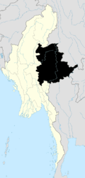
 Laukkaing Location in Burma | |
| Coordinates: 23°41′00″N 98°45′00″E / 23.68333°N 98.75000°ECoordinates: 23°41′00″N 98°45′00″E / 23.68333°N 98.75000°E | |
| Country |
|
| State | Shan State |
| Elevation[1] | 991 m (3,251 ft) |
| Time zone | MST (UTC+6.30) |
Laogai District (Burmese: လောက်ကိုင်ခရိုင်) is a district of the Shan State in Myanmar. It consists 2 towns and 333 villages.
It is Kokang Self-Administered Zone according to Myanmar Constitution (2008).[2]
Townships
The district contains the following townships:
- Laukkaing Township aka Laukkai Township[3]
- Kongyan Township aka Konkyan Township
See also
References

This article is issued from Wikipedia - version of the 8/18/2015. The text is available under the Creative Commons Attribution/Share Alike but additional terms may apply for the media files.