Mirabel, Quebec
| Mirabel | |
|---|---|
| City | |
| Ville de Mirabel | |
|
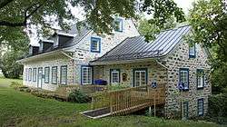
City hall of Mirabel | |
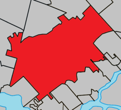 Location with surrounding municipalities | |
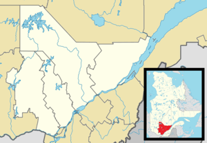 Mirabel Location in central Quebec | |
| Coordinates: 45°39′N 74°05′W / 45.650°N 74.083°WCoordinates: 45°39′N 74°05′W / 45.650°N 74.083°W[1] | |
| Country |
|
| Province |
|
| Region | Laurentides |
| RCM | None |
| Constituted | January 1, 1971 |
| Government[2] | |
| • Mayor | Jean Bouchard |
| • Federal riding | Mirabel |
| • Prov. riding | Mirabel |
| Area[2][3] | |
| • Total | 486.80 km2 (187.95 sq mi) |
| • Land | 485.59 km2 (187.49 sq mi) |
| Population (2011)[3] | |
| • Total | 41,957 |
| • Density | 86.4/km2 (224/sq mi) |
| • Pop 2006-2011 |
|
| • Dwellings | 16,374 |
| Time zone | EST (UTC−5) |
| • Summer (DST) | EDT (UTC−4) |
| Postal code(s) | J7J, J7N |
| Area code(s) | 450 and 579 |
| Highways |
|
| Website |
www |

Mirabel is an off-island suburb of Montreal, located Southern Quebec.
Mirabel is also the name of a territory equivalent to a regional county municipality (TE) and census division (CD) of Quebec, coextensive with the city of Mirabel.[3] Its geographical code is 74. Prior to 2002, Mirabel was not only a city but also comprised the Mirabel Regional County Municipality.
The city is home to Montréal-Mirabel International Airport.
History
Mirabel was formed through the expropriation of private lands and the merger of 8 municipalities in 1971. The former municipalities were (with their individual founding dates in brackets): Saint-Augustin (1855); Saint-Benoît (1855); Saint-Hermas (1855); Saint-Janvier-de-Blainville (1855); Sainte-Scholastique (1855); Saint-Canut (1857); Sainte-Monique (1872), and Saint-Janvier-de-la-Croix (1959). Initially called Ville de Sainte-Scholastique and renamed to Mirabel in 1973, the city was planned to become a vast transportation and industrial hub for eastern Canada with Montréal-Mirabel International Airport at its centre.[4]
The airport, which opened in 1975, never became a major aviation hub and the industrial parks never materialized, and in 2004 the airport closed to all passenger traffic.
In 2000, about 10 square kilometres of Mirabel's territory was annexed by Lachute.
Communities
- La Belle-Rivière
- La Chapelle
- Mirabel-en-Haut
- Petit St-Charles
- Saint-Augustin
- Saint-Benoît
- Saint-Canut
- Sainte-Monique
- Saint-Hermas
- Saint-Janvier
- Sainte-Scholastique
Demographics
Population
| Canada census – Mirabel, Quebec community profile | |||
|---|---|---|---|
| 2011 | 2006 | 2001 | |
| Population: | 41,957 (+21.2% from 2006) | 34,626 (+26.8% from 2001) | 27,330 (+20.8% from 1996) |
| Land area: | 485.59 km2 (187.49 sq mi) | 485.51 km2 (187.46 sq mi) | 485.41 km2 (187.42 sq mi) |
| Population density: | 86.4/km2 (224/sq mi) | 71.3/km2 (185/sq mi) | 56.3/km2 (146/sq mi) |
| Median age: | 35.0 (M: 35.1, F: 34.8) | 34.3 (M: 34.6, F: 33.9) | 33.7 (M: 34.2, F: 33.2) |
| Total private dwellings: | 16,374 | 13,161 | 10,067 |
| Median household income: | $67,023 | $59,981 | $49,061 |
| References: 2011[3] 2006[5] 2001[6] | |||
| Historical Census Data - Mirabel, Quebec[7] | |||||||||||||||||||||||||||||||||||
|---|---|---|---|---|---|---|---|---|---|---|---|---|---|---|---|---|---|---|---|---|---|---|---|---|---|---|---|---|---|---|---|---|---|---|---|
|
|
| |||||||||||||||||||||||||||||||||
Language
| Canada Census Mother Tongue - Mirabel, Quebec[7] | ||||||||||||||||||
|---|---|---|---|---|---|---|---|---|---|---|---|---|---|---|---|---|---|---|
| Census | Total | French |
English |
French & English |
Other | |||||||||||||
| Year | Responses | Count | Trend | Pop % | Count | Trend | Pop % | Count | Trend | Pop % | Count | Trend | Pop % | |||||
| 2011 |
41,810 |
40,050 | |
95.79% | 820 | |
1.96% | 240 | |
0.57% | 700 | |
1.67% | |||||
| 2006 |
34,475 |
33,185 | |
96.26% | 510 | |
1.48% | 180 | |
0.52% | 600 | |
1.74% | |||||
| 2001 |
27,115 |
26,060 | |
96.11% | 460 | |
1.70% | 155 | |
0.57% | 440 | |
1.62% | |||||
| 1996 |
22,465 |
21,605 | n/a | 96.17% | 450 | n/a | 2.00% | 145 | n/a | 0.65% | 265 | n/a | 1.18% | |||||
Climate
| Climate data for Mirabel (Montréal–Mirabel International Airport) 1981−2010 | |||||||||||||
|---|---|---|---|---|---|---|---|---|---|---|---|---|---|
| Month | Jan | Feb | Mar | Apr | May | Jun | Jul | Aug | Sep | Oct | Nov | Dec | Year |
| Record high humidex | 12.5 | 12.3 | 21.7 | 34.2 | 39.4 | 45.5 | 45.5 | 45.4 | 40.2 | 32.7 | 22.9 | 18.6 | 45.5 |
| Record high °C (°F) | 12.0 (53.6) |
12.6 (54.7) |
21.8 (71.2) |
31.1 (88) |
31.4 (88.5) |
33.5 (92.3) |
33.6 (92.5) |
36.1 (97) |
33.3 (91.9) |
26.7 (80.1) |
19.8 (67.6) |
16.4 (61.5) |
36.1 (97) |
| Average high °C (°F) | −6.5 (20.3) |
−4.3 (24.3) |
1.3 (34.3) |
10.8 (51.4) |
18.5 (65.3) |
23.4 (74.1) |
25.7 (78.3) |
24.7 (76.5) |
19.9 (67.8) |
12.5 (54.5) |
4.7 (40.5) |
−2.7 (27.1) |
10.7 (51.3) |
| Daily mean °C (°F) | −11.5 (11.3) |
−9.5 (14.9) |
−3.6 (25.5) |
5.4 (41.7) |
12.4 (54.3) |
17.4 (63.3) |
19.8 (67.6) |
18.7 (65.7) |
14.1 (57.4) |
7.3 (45.1) |
0.6 (33.1) |
−7.1 (19.2) |
5.3 (41.5) |
| Average low °C (°F) | −16.5 (2.3) |
−14.8 (5.4) |
−8.5 (16.7) |
0.0 (32) |
6.3 (43.3) |
11.4 (52.5) |
14.0 (57.2) |
12.7 (54.9) |
8.1 (46.6) |
2.0 (35.6) |
−3.4 (25.9) |
−11.5 (11.3) |
0.0 (32) |
| Record low °C (°F) | −37.0 (−34.6) |
−33.1 (−27.6) |
−29.9 (−21.8) |
−15.4 (4.3) |
−3.9 (25) |
−0.9 (30.4) |
4.8 (40.6) |
1.1 (34) |
−5.3 (22.5) |
−8.0 (17.6) |
−22.1 (−7.8) |
−33.0 (−27.4) |
−37.0 (−34.6) |
| Record low wind chill | −50.0 | −44.0 | −40.0 | −24.0 | −10.0 | −3.0 | 0.0 | 0.0 | −7.0 | −12.0 | −28.0 | −46.0 | −50.0 |
| Average precipitation mm (inches) | 87.9 (3.461) |
64.6 (2.543) |
70.4 (2.772) |
88.0 (3.465) |
86.8 (3.417) |
103.1 (4.059) |
91.9 (3.618) |
96.0 (3.78) |
91.7 (3.61) |
96.5 (3.799) |
103.2 (4.063) |
87.6 (3.449) |
1,067.7 (42.035) |
| Average rainfall mm (inches) | 32.0 (1.26) |
21.8 (0.858) |
30.7 (1.209) |
72.9 (2.87) |
86.5 (3.406) |
103.1 (4.059) |
91.9 (3.618) |
95.9 (3.776) |
91.7 (3.61) |
93.1 (3.665) |
80.4 (3.165) |
36.0 (1.417) |
835.9 (32.909) |
| Average snowfall cm (inches) | 55.8 (21.97) |
43.1 (16.97) |
38.5 (15.16) |
14.0 (5.51) |
0.3 (0.12) |
0.0 (0) |
0.0 (0) |
0.0 (0) |
0.0 (0) |
3.1 (1.22) |
22.8 (8.98) |
51.3 (20.2) |
228.8 (90.08) |
| Average precipitation days (≥ 0.2 mm) | 16.8 | 14.0 | 13.8 | 13.0 | 13.7 | 13.2 | 12.7 | 12.0 | 11.4 | 13.8 | 16.1 | 17.1 | 167.5 |
| Average rainy days (≥ 0.2 mm) | 4.4 | 3.9 | 6.4 | 11.2 | 13.7 | 13.2 | 12.7 | 12.0 | 11.4 | 13.4 | 11.5 | 5.9 | 119.6 |
| Average snowy days (≥ 0.2 cm) | 15.2 | 12.1 | 9.9 | 4.0 | 0.2 | 0.0 | 0.0 | 0.0 | 0.0 | 1.1 | 6.8 | 14.0 | 63.3 |
| Average relative humidity (%) (at 1500 LST) | 66.0 | 61.3 | 58.0 | 50.9 | 51.0 | 56.2 | 58.3 | 58.9 | 60.7 | 61.5 | 68.9 | 71.3 | 60.2 |
| Source: Environment Canada (normals, 1981−2010)[9] | |||||||||||||
Economy
When Nolisair (Nationair) was in existence, its headquarters were in the Nationair Building on the property of Montréal-Mirabel International Airport.[10]
Bombardier Aerospace produces the CRJ700, CRJ900 & CRJ1000 regional jetliners and will begin production of the Bombardier CSeries in late 2015 at the Montreal-Mirabel International Airport. Bell Helicopters also has its major manufacturing & final assembly plant at the airport.
Education
The Commission scolaire de la Seigneurie-des-Mille-Iles serves the following parts of Mirabel: Saint-Augustin, Saint-Benoît, Sainte-Scholastique and a portion of Domaine-Vert.[11]
- École primaire de la Clé-des-Champs[12]
- École primaire Girouard[13]
- École primaire Prés fleuris[14]
- École primaire Sainte-Scholastique[15]
The Commission scolaire de la Rivière-du-Nord operates Francophone public schools in other parts of Mirabel. They include:
Secondary schools:
- École secondaire de Mirabel (ESM)
Primary schools:[16]
- à l'Unisson
- aux Quatre-Vents
- de la Croisée-des-Champs
- Mer-et-Monde
- Saint-Anne
- Saint-Hermas
The Sir Wilfrid Laurier School Board operates Anglophone public schools in the area around Mirabel. Schools serving Mirabel include:
- Lake of Two Mountains High School in Deux-Montagnes[17]
- Laurentia Elementary School in Saint-Jérôme[18]
- Mountainview Elementary School in Deux-Montagnes[19]
- Saint Jude Elementary School in Deux-Montagnes[20]
Sister cities
- Châlons-en-Champagne (France)
 St-Scholastique
 St-Monique
See also
- List of regional county municipalities and equivalent territories in Quebec
- Mirabel Aerospace Centre
- Saint Pierre River (Mirabel), a river
- Rivière aux Chiens (rivière des Mille Îles), a river
References
- ↑ Reference number 72473 of the Commission de toponymie du Québec (French)
- 1 2 Geographic code 74005 in the official Répertoire des municipalités (French)
- 1 2 3 4 "2011 Community Profiles". Canada 2011 Census. Statistics Canada. July 5, 2013. Retrieved 2014-04-12.
- ↑ "Mirabel (ville)" (in French). Commission de toponymie du Québec. Retrieved 2009-03-10.
- ↑ "2006 Community Profiles". Canada 2006 Census. Statistics Canada. March 30, 2011. Retrieved 2014-04-12.
- ↑ "2001 Community Profiles". Canada 2001 Census. Statistics Canada. February 17, 2012. Retrieved 2014-04-12.
- 1 2 Statistics Canada: 1996, 2001, 2006, 2011 census
- ↑ http://www.mamrot.gouv.qc.ca/repertoire-des-municipalites/fiche/municipalite/74005/
- ↑ "Montréal–Mirabel International Airport]". Canadian Climate Normals 1981−2010. Retrieved 2016-05-12.
- ↑ The Europa World Year Book, 1989. Europa Publications, August 1, 1991. 667. Retrieved from Google Books on June 11, 2012. "Nationair Canada: Nationair Bldg, Cargo Rd Al, Montreal International Airport (Mirabel), Mirabel, Que J7N 1A5"
- ↑ "Admission et inscription." Commission scolaire de la Seigneurie-des-Mille-Iles. Retrieved on December 7, 2014. "La Commission scolaire de la Seigneurie-des-Mille-Iles (CSSMI) offre ses services aux résidents des municipalités de : Blainville, Boisbriand, Bois-des-Filion, Deux-Montagnes, Lorraine, Mirabel (Saint-Augustin, Saint-Benoît, Sainte-Scholastique et secteur du Domaine-Vert), Oka, Pointe-Calumet, Rosemère, Sainte-Anne-des-Plaines, Sainte-Marthe-sur-le-Lac, Sainte-Thérèse, Saint-Eustache, Saint-Joseph-du-Lac, Saint-Placide et Terrebonne Ouest."
- ↑ "Accueil." École primaire de la Clé-des-Champs. Retrieved on December 8, 2014.
- ↑ "Girouard." Commission scolaire de la Seigneurie-des-Mille-Iles. Retrieved on December 8, 2014.
- ↑ "Prés fleuris." Commission scolaire de la Seigneurie-des-Mille-Iles. Retrieved on December 8, 2014.
- ↑ "Sainte-Scholastique." Commission scolaire de la Seigneurie-des-Mille-Iles. Retrieved on December 8, 2014.
- ↑ "Préscolaire / primaire." Commission scolaire de la Rivière-du-Nord. Retrieved on December 7, 2014.
- ↑ "Overview." Lake of Two Mountains High School. Retrieved on December 8, 2014.
- ↑ "Laurentia Elementary School Zone Map." Sir Wilfrid Laurier School Board. Retrieved on December 7, 2014.
- ↑ "Mountainview Elementary School Zone Map." Sir Wilfrid Laurier School Board. Retrieved on December 8, 2014.
- ↑ "Saint Jude Elementary School Zone Map." Sir Wilfrid Laurier School Board. Retrieved on December 8, 2014.
External links
| Wikimedia Commons has media related to Mirabel, Quebec. |
 |
Saint-Colomban / Saint-Jérôme | Sainte-Sophie Sainte-Anne-des-Plaines |
| |
| Lachute Saint-André-d'Argenteuil |
|
Blainville Ste-Thérèse Boisbriand | ||
| ||||
| | ||||
| Saint-Placide | Oka / Kanesatake / Saint-Joseph-du-Lac | Saint-Eustache |
| |
La Rivière-du-Nord RCM | | ||
| Argenteuil RCM | |
Thérèse-De Blainville RCM | ||
| ||||
| | ||||
| Deux-Montagnes RCM |
| Cities/towns | |
|---|---|
| Municipalities | |
| Townships | |
| Parishes | |
| Villages | |
| |