Milton Mills, New Hampshire
| Milton Mills, New Hampshire | |
|---|---|
| Census-designated place | |
|
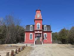
Milton Free Public Library | |
 Milton Mills  Milton Mills | |
| Coordinates: 43°30′00″N 70°57′38″W / 43.50000°N 70.96056°WCoordinates: 43°30′00″N 70°57′38″W / 43.50000°N 70.96056°W | |
| Country | United States |
| State | New Hampshire |
| County | Strafford |
| Town | Milton |
| Area | |
| • Total | 0.8 sq mi (2.2 km2) |
| • Land | 0.8 sq mi (2.2 km2) |
| • Water | 0.0 sq mi (0.0 km2) |
| Elevation | 462 ft (141 m) |
| Population (2010) | |
| • Total | 299 |
| • Density | 350/sq mi (140/km2) |
| Time zone | Eastern (EST) (UTC-5) |
| • Summer (DST) | EDT (UTC-4) |
| ZIP code | 03852 |
| Area code(s) | 603 |
| FIPS code | 33-48740 |
| GNIS feature ID | 0868472 |
Milton Mills is a census-designated place in the town of Milton in Strafford County, New Hampshire. It had a population of 299 at the 2010 census.[1]
The village is located in the northern part of the town of Milton, adjacent to the Salmon Falls River, which forms the border between New Hampshire and Maine. Applebee Road leads southwest to New Hampshire Route 125 and the center of Milton, Willey Road leads northwest to the town of Wakefield, Milton Mills Road leads east to Maine Route 109 in the town of Acton, Maine, and Foxes Ridge Road leads southeast to Lebanon, Maine, and U.S. Route 202.
Milton Mills has a separate ZIP code (03852) from the rest of the town of Milton.
References
- ↑ United States Census Bureau, American FactFinder, 2010 Census figures. Retrieved March 23, 2011.
Municipalities and communities of Strafford County, New Hampshire, United States | ||
|---|---|---|
| Cities | 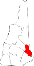 | |
| Towns | ||
| CDPs | ||
| Other villages | ||
This article is issued from Wikipedia - version of the 7/13/2016. The text is available under the Creative Commons Attribution/Share Alike but additional terms may apply for the media files.