New Durham, New Hampshire
| New Durham, New Hampshire | ||
|---|---|---|
| Town | ||
|
| ||
| ||
 Location in Strafford County, New Hampshire | ||
| Coordinates: 43°26′05″N 71°09′50″W / 43.43472°N 71.16389°WCoordinates: 43°26′05″N 71°09′50″W / 43.43472°N 71.16389°W | ||
| Country | United States | |
| State | New Hampshire | |
| County | Strafford | |
| Incorporated | 1762 | |
| Government | ||
| • Board of Selectmen |
David Bickford, Chair David Swenson Gregory Anthes | |
| • Town Administrator | Scott Kinmond | |
| Area | ||
| • Total | 44.1 sq mi (114.3 km2) | |
| • Land | 41.5 sq mi (107.5 km2) | |
| • Water | 2.6 sq mi (6.8 km2) 5.98% | |
| Elevation | 544 ft (166 m) | |
| Population (2010) | ||
| • Total | 2,638 | |
| • Density | 60/sq mi (23/km2) | |
| Time zone | Eastern (UTC-5) | |
| • Summer (DST) | Eastern (UTC-4) | |
| ZIP code | 03855 | |
| Area code(s) | 603 | |
| FIPS code | 33-51220 | |
| GNIS feature ID | 0873677 | |
| Website |
www | |
New Durham is a town in Strafford County, New Hampshire, United States. The population was 2,638 at the 2010 census.[1] It is drained by the Merrymeeting and Ela rivers, and is known for Merrymeeting Lake. New Durham is home to the Powder Mill Fish Hatchery. Also located here is the Lions Club's Camp Pride, a camp for children and adults with special needs.
History
Granted by the Masonian Proprietors in 1749 as Cochecho Township, New Durham was settled in 1750 almost entirely by colonists from Durham. It would be incorporated as New Durham on December 7, 1762. With a somewhat uneven and rocky surface, the town was better suited to grazing than cultivation. Lumber became the chief article of trade, and by 1859 New Durham had five sawmills and four shingle mills. It also had two gristmills, and a gunpowder factory called the Eureka Powder Works.[2] On September 19, 1849, the Cocheco Railroad opened through the town, connecting Dover with Alton Bay.[3]
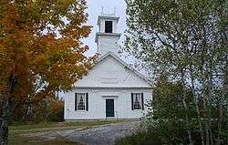
An early town minister, Reverend Benjamin Randall, founded a new religious denomination in 1780 called the Free Will Baptists, later known as Free Baptists. The church has two buildings in the community, the older built in 1819 on New Durham Ridge.[2]
Geography
According to the United States Census Bureau, the town has a total area of 44.1 square miles (114 km2), of which 41.5 sq mi (107 km2) is land and 2.6 sq mi (6.7 km2) is water, comprising 5.98% of the town.[4] It is drained by the Ela River, Merrymeeting River and the Cocheco River. New Durham's highest point is 1,700 feet (520 m) above sea level, on the western slope of Copple Crown Mountain, along the town's eastern border. The mountain's 1,868-foot (569 m) summit is in the neighboring town of Brookfield.
New Durham is served by New Hampshire Route 11.
Demographics
| Historical population | |||
|---|---|---|---|
| Census | Pop. | %± | |
| 1790 | 554 | — | |
| 1800 | 742 | 33.9% | |
| 1810 | 888 | 19.7% | |
| 1820 | 1,168 | 31.5% | |
| 1830 | 1,162 | −0.5% | |
| 1840 | 1,032 | −11.2% | |
| 1850 | 1,049 | 1.6% | |
| 1860 | 1,173 | 11.8% | |
| 1870 | 973 | −17.1% | |
| 1880 | 772 | −20.7% | |
| 1890 | 579 | −25.0% | |
| 1900 | 625 | 7.9% | |
| 1910 | 523 | −16.3% | |
| 1920 | 462 | −11.7% | |
| 1930 | 448 | −3.0% | |
| 1940 | 433 | −3.3% | |
| 1950 | 463 | 6.9% | |
| 1960 | 474 | 2.4% | |
| 1970 | 583 | 23.0% | |
| 1980 | 1,183 | 102.9% | |
| 1990 | 1,974 | 66.9% | |
| 2000 | 2,220 | 12.5% | |
| 2010 | 2,638 | 18.8% | |
| Est. 2015 | 2,658 | [5] | 0.8% |
As of the census[7] of 2000, there were 2,220 people, 819 households, and 630 families residing in the town. The population density was 53.2 people per square mile (20.6/km²). There were 1,309 housing units at an average density of 31.4 per square mile (12.1/km²). The racial makeup of the town was 98.15% White, 0.23% African American, 0.18% Native American, 0.54% Asian, 0.27% from other races, and 0.63% from two or more races. Hispanic or Latino of any race were 0.41% of the population.
There were 819 households out of which 36.1% had children under the age of 18 living with them, 67.2% were married couples living together, 4.9% had a female householder with no husband present, and 23.0% were non-families. 17.0% of all households were made up of individuals and 5.6% had someone living alone who was 65 years of age or older. The average household size was 2.71 and the average family size was 3.05.
In the town the population was spread out with 27.3% under the age of 18, 4.3% from 18 to 24, 32.8% from 25 to 44, 24.9% from 45 to 64, and 10.7% who were 65 years of age or older. The median age was 38 years. For every 100 females there were 107.7 males. For every 100 females age 18 and over, there were 106.5 males.
The median income for a household in the town was $52,270, and the median income for a family was $52,941. Males had a median income of $35,574 versus $28,092 for females. The per capita income for the town was $22,139. About 3.7% of families and 5.1% of the population were below the poverty line, including 5.9% of those under age 18 and 6.6% of those age 65 or over.
See also
Notable people
- Alfred M. Jones, Midwest politician and businessman born in New Durham[8]
- Benjamin Randall (1749–1808), minister
References
- ↑ United States Census Bureau, American FactFinder, 2010 Census figures. Retrieved March 23, 2011.
- 1 2 Coolidge, Austin J.; John B. Mansfield (1859). A History and Description of New England. Boston, Massachusetts. pp. 596–597.
- ↑ Report of the Directors of the Boston & Maine Railroad to the Stockholders, September 12, 1849
- ↑ "Geographic Identifiers: 2010 Demographic Profile Data (G001) - New Durham town, New Hampshire". U.S. Census Bureau American Factfinder. Retrieved November 15, 2011.
- ↑ "Annual Estimates of the Resident Population for Incorporated Places: April 1, 2010 to July 1, 2015". Retrieved July 2, 2016.
- ↑ "Census of Population and Housing". Census.gov. Retrieved June 4, 2016.
- ↑ "American FactFinder". United States Census Bureau. Retrieved 2008-01-31.
- ↑ 'Wisconsin Blue Book 1901,' Biographical Sketch of Alfred Miles Jones, pg. 739
External links
- Town of New Durham official website
- New Durham Public Library
- PowderMill Snowmobile Club
- New Hampshire Economic and Labor Market Information Bureau Profile
- First Free Will Baptist Church of America - New Durham
Municipalities and communities of Strafford County, New Hampshire, United States | ||
|---|---|---|
| Cities | 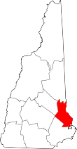 | |
| Towns | ||
| CDPs | ||
| Other villages | ||