Farmington, New Hampshire
| Farmington, New Hampshire | ||
|---|---|---|
| Town | ||
|
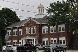
Farmington town hall | ||
| ||
 Location within Strafford County, New Hampshire | ||
| Coordinates: 43°23′23″N 71°03′56″W / 43.38972°N 71.06556°WCoordinates: 43°23′23″N 71°03′56″W / 43.38972°N 71.06556°W | ||
| Country | United States | |
| State | New Hampshire | |
| County | Strafford | |
| Settled | 1770s | |
| Incorporated | 1798 | |
| Government | ||
| • Board of Selectmen |
Charlie King, Chair Neil Johnson James Horgan Ann Titus Paula Proulx | |
| • Town Administrator | Arthur Capello | |
| Area | ||
| • Total | 37.5 sq mi (97.2 km2) | |
| • Land | 37.2 sq mi (96.4 km2) | |
| • Water | 0.3 sq mi (0.8 km2) | |
| Elevation | 285 ft (87 m) | |
| Population (2010) | ||
| • Total | 6,786 | |
| • Density | 180/sq mi (70/km2) | |
| Time zone | EST (UTC-5) | |
| • Summer (DST) | EDT (UTC-4) | |
| ZIP code | 03835 | |
| Area code(s) | 603 | |
| FIPS code | 33-26020 | |
| GNIS feature ID | 0873596 | |
| Website |
www | |

Farmington is a town located in Strafford County, New Hampshire, United States. The 2010 census reported that the town had a total population of 6,786.[1] Farmington is home to Blue Job State Forest.
The compact town center, where 3,885 people resided at the 2010 census,[2] is defined by the U.S. Census Bureau as the Farmington census-designated place and is located at the junction of New Hampshire routes 75 and 153.
History
Abenaki Indians once used the Cochecho River for transportation, and had a camping ground on Meetinghouse Hill, where they built birch bark canoes. Otherwise, the river valley was wilderness, through which Indians from the north traveled after crossing Lake Winnipesaukee on their way to raid settlements in and around Dover. To stop the raids, in 1721 the Colonial Assembly in Portsmouth approved construction of a fort at the foot of the lake, with a soldiers' road built from Dover to supply it. In 1722, Bay Road was surveyed and completed. Along its course the town of Farmington would grow.
The settlement began as the Northwest Parish of Rochester, which was chartered in 1722. The last Indian attack in the general region occurred in 1748, but by 1749, Native Americans had disappeared from warfare and disease. Farmers cultivated the rocky soil, and gristmills used water power of streams to grind their grain. Sawmills cut the abundant timber, and the first frame house at the village was built in 1782. In 1790, Jonas March from Portsmouth established a store, behind which teamsters unloaded on his dock the lumber he traded. The area became known as March's Dock, Farmington Dock, and finally just The Dock.
Inhabitants of the Northwest Parish were taxed to support both the meetinghouse and minister on Rochester Hill about twelve miles away, a distance which made attendance difficult. A movement began in the 1770s to establish a separate township, and in 1783 a petition for charter was submitted to the state legislature. It was denied, but another petition in 1798 was granted. With about 1,000 inhabitants, Farmington was incorporated.[3] In 1800, a 40 by 50 foot, two story meetinghouse was erected on Meetinghouse Hill. The same year, John Wingate established a blacksmithy. He would also become proprietor of Wingate's Tavern.
In the 19th century, the community developed a prime shoemaking industry, and was one of the first places to use automated machines instead of handwork. In 1836, shoe manufacturing began at a shop on Spring Street built by E. H. Badger, although it was soon abandoned to creditors. Martin Luther Hayes took over the business, and by 1840 was successful enough to enlarge the building. The town would be connected by railroad to Dover in 1849, the line extended to Alton Bay in 1851. Shoes were shipped to Boston to be sold at semi-annual auctions for 50 cents a pair.[3]
Following the Civil War, the shoe business boomed and numerous factories were built. Despite a fire in 1875 which destroyed much of the center of town, Farmington was known as "The Shoe Capital of New Hampshire." Other factories produced knives, knit underwear, wooden boxes, wooden handles and carriages. Brushes were manufactured by the F. W. Browne Company, from which Booker T. Washington ordered twelve street brooms in 1915 for use at the Tuskegee Institute. The town had five blacksmith shops. But the Panic of 1893 closed all but two large shoe factories. The industry faded in the 20th century, when most of the factories were demolished.
 Central Street in 1908
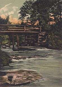
 Cochecho River in 1912
 Central House in 1913
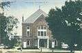 Opera House in 1914
 Shoe factory in 1915
Geography
According to the United States Census Bureau, the town has a total area of 37.5 square miles (97.1 km2), of which 37.2 square miles (96.3 km2) is land and 0.3 square miles (0.8 km2) is water, comprising 0.85% of the town.[4] The town center (census-designated place) has a total area of 6.4 sq mi (17 km2), all of it land.
Farmington is drained by the Ela River, Mad River and Cochecho River. Part of the Blue Hills Range, foothills of the White Mountains, is in the southwest. The highest point in Farmington is Blue Job Mountain, at 1,350 feet (410 m) above sea level. Farmington lies almost fully within the Piscataqua River (Coastal) watershed, with the westernmost corner of town located in the Merrimack River watershed.[5]
The town is crossed by New Hampshire Route 11, New Hampshire Route 75 and New Hampshire Route 153.
Demographics
| Historical population | |||
|---|---|---|---|
| Census | Pop. | %± | |
| 1800 | 1,029 | — | |
| 1810 | 1,272 | 23.6% | |
| 1820 | 1,716 | 34.9% | |
| 1830 | 1,464 | −14.7% | |
| 1840 | 1,380 | −5.7% | |
| 1850 | 1,699 | 23.1% | |
| 1860 | 2,275 | 33.9% | |
| 1870 | 2,063 | −9.3% | |
| 1880 | 3,044 | 47.6% | |
| 1890 | 3,064 | 0.7% | |
| 1900 | 2,265 | −26.1% | |
| 1910 | 2,621 | 15.7% | |
| 1920 | 2,461 | −6.1% | |
| 1930 | 2,698 | 9.6% | |
| 1940 | 3,095 | 14.7% | |
| 1950 | 3,454 | 11.6% | |
| 1960 | 3,287 | −4.8% | |
| 1970 | 3,588 | 9.2% | |
| 1980 | 4,630 | 29.0% | |
| 1990 | 5,739 | 24.0% | |
| 2000 | 5,774 | 0.6% | |
| 2010 | 6,786 | 17.5% | |
| Est. 2015 | 6,832 | [6] | 0.7% |
As of the 2010 census, there were 6,786 people, 2,592 households, and 1,813 families residing in the town. The population density was 180.8 people per square mile (69.8/km²). There were 2,832 housing units, at an average density of 76.1 units per square mile (29.4/km²). The racial makeup of the town was 96.8% white, 0.5% African American, 0.3% American Indian or Alaska Native, 0.5% Asian, 0.1% Native Hawaiian or other Pacific Islander, 0.2% some other race, and 1.7% from two or more races. 0.8% of the population were Hispanic or Latino of any race.
There were 2,592 households counted at the 2010 census, out of which 29.7% had children under the age of 18 living with them, 51.0% were headed by married couples living together, 12.6% had a female householder with no husband present, and 30.1% were non-families. 22.0% of all households were made up of individuals, and 7.9% had someone living alone who was 65 years of age or older. The average household size was 2.62, and the average family size was 3.01.
In the town the 2010 population was spread out with 23.9% under the age of 18, 8.5% from 18 to 24, 26.4% from 25 to 44, 30.2% from 45 to 64, and 11.1% who are 65 years of age or older. The median age was 39.2 years. For every 100 females there were 98.7 males. For every 100 females age 18 and over, there were 96.0 males.[1]
At the 2000 census, the median income for a household in the town was $40,971, which was 9% below the county average, and 17% below the state average. The median income for a family was $44,788. Males had a median income of $32,320 versus $24,527 for females. The per capita income for the town was $16,574. 9.5% of the population and 6.3% of families were below the poverty line. Out of the total people living in poverty, 8.1% were under the age of 18 and 11.2% were 65 or older.
Although the town has about the same percentage of population below the poverty line as does the county, the town has a disproportionate share of the county’s low income residents living just above the poverty line, and a disproportionately small share of the county’s affluent households. This means that with changing socio-economic pressures, a larger portion of town's population is at risk of falling into poverty than is the case elsewhere in the county.
Town center

As of the census of 2010, there were 3,885 people, 1,510 households, and 1,000 families residing in the densely populated center of town, or census-designated place (CDP). The population density was 607.0 people per square mile (228.5/km²). There were 1,645 housing units at an average density of 257.0 units per square mile (96.8/km²). The racial makeup of the community was 96.4% white, 0.4% African American, 0.3% American Indian or Alaska Native, 0.7% Asian, 0.2% Native Hawaiian or other Pacific Islander, 0.1% some other race, and 1.9% from two or more races. 0.9% of the population were Hispanic or Latino of any race.
There were 1,510 households, out of which 30.3% had children under the age of 18 living with them, 44.6% were headed by married couples living together, 15.0% had a female householder with no husband present, and 33.8% were non-families. 25.3% of all households were made up of individuals, and 9.1% had someone living alone who was 65 years of age or older. The average household size was 2.57, and the average family size was 3.01.
In the community the population was spread out with 24.5% under the age of 18, 9.7% from 18 to 24, 26.5% from 25 to 44, 27.9% from 45 to 64, and 11.5% who were 65 years of age or older. The median age was 37.6 years. For every 100 females there were 96.7 males. For every 100 females age 18 and over, there were 93.7 males.[2]
At the 2000 census, the median income for a household in the village area was $35,313, and the median income for a family was $39,931. Males had a median income of $31,952 versus $24,617 for females. The per capita income for the community was $15,048. 12.7% of the population and 8.8% of families were below the poverty line. Out of the total people living in poverty, 11.0% are under the age of 18 and 15.3% are 65 or older.
Notable people

- Shirley Barker, writer
- Harry Bemis, catcher with the Cleveland Naps
- Nehemiah Eastman, lawyer and US congressman
- Winfield Scott Edgerly, US Army brigadier general
- LacyJane Folger, Miss New Hampshire USA 2011
- Joseph W. Furber, Minnesota legislator
- Joseph Hammons, US congressman
- Wingate Hayes, US Attorney, Speaker of Rhode Island House of Representatives
- Alonzo Nute, US congressman
- Lawrence Lee Pelletier, college president
- Mary Lemist Titcomb, librarian
- Henry Wilson, 18th Vice-President of the United States (1873–1875)
References
- 1 2 "Profile of General Population and Housing Characteristics: 2010 Demographic Profile Data (DP-1): Farmington town, Strafford County, New Hampshire". U.S. Census Bureau, American Factfinder. Retrieved February 24, 2012.
- 1 2 "Profile of General Population and Housing Characteristics: 2010 Demographic Profile Data (DP-1): Farmington CDP, New Hampshire". U.S. Census Bureau, American Factfinder. Retrieved February 24, 2012.
- 1 2 A. J. Coolidge & J. B. Mansfield, A History and Description of New England; Boston, Massachusetts 1859
- ↑ "Geographic Identifiers: 2010 Demographic Profile Data (G001) - Farmington town, Strafford County, New Hampshire". U.S. Census Bureau American Factfinder. Retrieved November 15, 2011.
- ↑ Foster, Debra H.; Batorfalvy, Tatianna N.; Medalie, Laura (1995). Water Use in New Hampshire: An Activities Guide for Teachers. U.S. Department of the Interior and U.S. Geological Survey.
- ↑ "Annual Estimates of the Resident Population for Incorporated Places: April 1, 2010 to July 1, 2015". Retrieved July 2, 2016.
- ↑ "Census of Population and Housing". Census.gov. Retrieved June 4, 2016.
Further reading
- The Bicentennial History Committee, The History of Farmington, NH, from the Days of the Northwest Parish to the Present Time, The Foster Press, Farmington, NH 1976
External links
| Wikimedia Commons has media related to Farmington, New Hampshire. |
- Town of Farmington official website
- Farmington Historical Society
- Farmington Community Gardens
- Goodwin Library
- New Hampshire Economic and Labor Market Information Bureau Profile
Municipalities and communities of Strafford County, New Hampshire, United States | ||
|---|---|---|
| Cities | 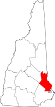 | |
| Towns | ||
| CDPs | ||
| Other villages | ||