Rollinsford, New Hampshire
| Rollinsford, New Hampshire | |
|---|---|
| Town | |
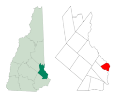 Location within Strafford County, New Hampshire | |
| Coordinates: 43°14′10″N 70°49′08″W / 43.23611°N 70.81889°WCoordinates: 43°14′10″N 70°49′08″W / 43.23611°N 70.81889°W | |
| Country | United States |
| State | New Hampshire |
| County | Strafford |
| Settled | 1630s |
| Incorporated | 1849[1] |
| Government | |
| • Board of selectmen |
Suzanne Huard, Chair Michael Rollo Jodi Lavoie-Carnes |
| Area | |
| • Total | 7.5 sq mi (19.5 km2) |
| • Land | 7.3 sq mi (18.9 km2) |
| • Water | 0.2 sq mi (0.6 km2) |
| Elevation | 70 ft (21 m) |
| Population (2010) | |
| • Total | 2,527 |
| Time zone | EST (UTC-5) |
| • Summer (DST) | EDT (UTC-4) |
| ZIP codes | 03805, 03869 |
| Area code(s) | 603 |
| FIPS code | 33-65540 |
| GNIS feature ID | 0873709 |
| Website |
www |
Rollinsford is a town in Strafford County, New Hampshire, United States. The population was 2,527 at the 2010 census.[2] Rollinsford includes Salmon Falls Village.
History
The area was once within the domain of the Newichawannock Indians, an Abenaki sub-tribe which took its name from the Newichawannock River, meaning "river with many falls," now the Salmon Falls River. Their village was located at what is today Salmon Falls Village. They fished at the falls, stretching nets across the river to catch migrating salmon and other species swimming upriver to spawn. But war and disease, probably smallpox brought from abroad, decimated the native population.[3]
Subsequently settled by about 1630, the land was part of Dover, one of the original townships of New Hampshire. The area was first called Sligo, likely after the county Sligo in Ireland,[4] and the name survives on a town road. An historical marker on Sligo Road reads, "Near this place lived David Hamilton of Westburn born in the parish of Cambuslang, Scotland in October 1620; captured by Oliver Cromwell at the Battle of Worcester, England, September 3 1651; Brought to America as a prisoner in chains on the "John and Sarah" in the same year; settled near here and married Annah Jaxson of Lanark, Scotland. Killed by Indians on September 28, 1691." Hamilton's descendants still reside in this area of New Hampshire.
In 1729 the area was established as a parish called "Summersworth", meaning summer town, because the ministers preached here during the summer. In 1754, it was set off and incorporated as a town by colonial Governor Benning Wentworth, although thereafter spelled "Somersworth" due to a clerical error. Since the first settlers' arrival, small communities had developed near various sawmills and gristmills along the Salmon Falls River, but the center of "Summersworth" was located at Rollinsford Junction.
Beginning in the early 1820s, water powered textile mills were established at the larger falls, and the town was divided between them—Great Falls became Somersworth, and Salmon Falls became Rollinsford, incorporated in 1849. It was named in honor of the Rollins family, whose ancestor Judge Ichabod Rollins had settled there many generations before and had become the first probate judge for the state.[5]
Salmon Falls Village
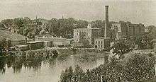
The village of Salmon Falls was founded in 1823 by a group of local investors led by James Rundlet of Portsmouth, who on June 17, 1822 incorporated the Salmon Falls Manufacturing Company to manufacture woolen cloth using the power of the Salmon Falls River, a Piscataqua River tributary.[6] After an 1834 fire destroyed the first factory built there, the company's Portsmouth-based investors built a new factory for cotton manufacturing, eventually selling the corporation to their Boston-based cotton broker Mason and Lawrence in the 1840s. As part of their expansion, the town was laid out in an easy-to-navigate grid plan, with the three-story boarding houses and an adjoining mill building made of brick to withstand fires. Two-story brick double houses were also built to accommodate the families of the overseers.[6] The town thrived into the first decades of the 20th century and eventually became home to many immigrant families whose forebears came to work in the mills. Ironically, though the town planners originally forbade the mill workers to drink alcohol and required that they attend church on Sunday, during Prohibition, its proximity to temperate Maine and the Boston & Maine Railroad line led to the establishment of numerous bars and a relatively short-lived but racy reputation for free-flowing liquor.
The New England cotton industry would fade in the early to mid-20th century, but would leave the brick town intact. Today, the mills have been reborn as low-cost studio space for more than 100 artists and artisans who use the converted studios for everything from painting, sculpting and crafting handmade furniture to teaching and practicing yoga and dance.
Geography
According to the United States Census Bureau, the town has a total area of 7.5 square miles (19.4 km2), of which 7.3 sq mi (18.9 km2) is land and 0.2 sq mi (0.5 km2) is water, comprising 3.32% of the town. Rollinsford is bounded on the east by the Salmon Falls River, but most of the town is drained by Rollins and Twombly brooks, which flow south to the Cochecho River in neighboring Dover. The highest point in town is an unnamed 300-foot (91 m) summit near the border with Somersworth. Garrison Hill, 290 feet (88 m) above sea level, occupies the town's border with Dover to the west.
Demographics
| Historical population | |||
|---|---|---|---|
| Census | Pop. | %± | |
| 1850 | 1,862 | — | |
| 1860 | 2,069 | 11.1% | |
| 1870 | 1,500 | −27.5% | |
| 1880 | 1,712 | 14.1% | |
| 1890 | 2,003 | 17.0% | |
| 1900 | 1,701 | −15.1% | |
| 1910 | 1,836 | 7.9% | |
| 1920 | 1,701 | −7.4% | |
| 1930 | 1,409 | −17.2% | |
| 1940 | 1,463 | 3.8% | |
| 1950 | 1,652 | 12.9% | |
| 1960 | 1,935 | 17.1% | |
| 1970 | 2,273 | 17.5% | |
| 1980 | 2,319 | 2.0% | |
| 1990 | 2,645 | 14.1% | |
| 2000 | 2,648 | 0.1% | |
| 2010 | 2,527 | −4.6% | |
| Est. 2015 | 2,527 | [7] | 0.0% |
As of the census[9] of 2000, there were 2,648 people, 1,033 households, and 721 families residing in the town. The population density was 363.0 people per square mile (140.2/km²). There were 1,060 housing units at an average density of 145.3 per square mile (56.1/km²). The racial makeup of the town was 97.77% White, 0.68% African American, 0.08% Native American, 0.53% Asian, 0.08% from other races, and 0.87% from two or more races. Hispanic or Latino of any race were 0.60% of the population.
There were 1,033 households out of which 34.1% had children under the age of 18 living with them, 58.4% were married couples living together, 7.6% had a female householder with no husband present, and 30.2% were non-families. 22.3% of all households were made up of individuals and 8.4% had someone living alone who was 65 years of age or older. The average household size was 2.56 and the average family size was 3.03.
In the town the population was spread out with 25.2% under the age of 18, 6.9% from 18 to 24, 33.0% from 25 to 44, 22.5% from 45 to 64, and 12.3% who were 65 years of age or older. The median age was 37 years. For every 100 females there were 97.8 males. For every 100 females age 18 and over, there were 95.1 males.
The median income for a household in the town was $48,588, and the median income for a family was $60,625. Males had a median income of $37,750 versus $26,068 for females. The per capita income for the town was $24,444. About 2.6% of families and 3.7% of the population were below the poverty line, including 5.2% of those under age 18 and 3.4% of those age 65 or over.
Notable people
- Dave Guard, folk singer with The Kingston Trio
- Dan Marsh (aka. Danny Davis), referee-turned-wrestler with the WWE
- Obo II, champion cocker spaniel and progenitor of every living American Cocker Spaniel
- Edward H. Rollins, state senator and US congressman
- Bill Staines, folk singer-songwriter
See also
References
- ↑ On 22 April 1754, Dover's parish of Somersworth was incorporated as a town, its population center located in what would later become Rollinsford on 3 July 1849
- ↑ United States Census Bureau, American FactFinder, 2010 Census figures. Retrieved March 23, 2011.
- ↑ Seacoast Watershed Information Manager website
- ↑ Thompson, Mary Pickering (1892). Landmarks in Ancient Dover, New Hampshire, pg 233
- ↑ Lyford, James Otis (1906). Life of Edward H. Rollins: A Political Biography. Boston: D. Estes & Co.Pg 27
- 1 2 Garner, John S. (1992). The Company Town: Architecture and Society in the Early Industrial Age. Oxford University Press. Pg 119
- ↑ "Annual Estimates of the Resident Population for Incorporated Places: April 1, 2010 to July 1, 2015". Retrieved July 2, 2016.
- ↑ "Census of Population and Housing". Census.gov. Retrieved June 4, 2016.
- ↑ "American FactFinder". United States Census Bureau. Retrieved 2008-01-31.
External links
- Town of Rollinsford official website
- New Hampshire Economic and Labor Market Information Bureau Profile
Municipalities and communities of Strafford County, New Hampshire, United States | ||
|---|---|---|
| Cities | 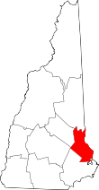 | |
| Towns | ||
| CDPs | ||
| Other villages | ||