Maple Meade, New Jersey
| Maple Meade, New Jersey | |
|---|---|
| Unincorporated community | |
|
Maple Meade from westbound Adams Lane at US 130 | |
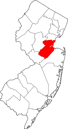
 Maple Meade, New Jersey  Maple Meade, New Jersey  Maple Meade, New Jersey Location of Maple Meade in Middlesex County Inset: Location of county within the state of New Jersey | |
| Coordinates: 40°26′37″N 74°28′32″W / 40.44361°N 74.47556°WCoordinates: 40°26′37″N 74°28′32″W / 40.44361°N 74.47556°W | |
| Country |
|
| State |
|
| County | Middlesex |
| Township | North Brunswick |
| Elevation[1] | 112 ft (34 m) |
| GNIS feature ID | 878099[1] |
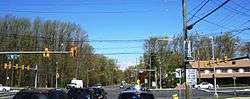
Maple Meade is an unincorporated community located within North Brunswick Township in Middlesex County, New Jersey, United States.[2] The area, located near the intersection of Adams Lane (County Route 608) and U.S. Route 130, is made up of homes and apartment complexes with businesses lining US 130.[3]
References
- 1 2 "Maple Meade". Geographic Names Information System. United States Geological Survey.
- ↑ Locality Search, State of New Jersey. Accessed February 10, 2015.
- ↑ Google (May 17, 2015). "Maple Meade, New Jersey" (Map). Google Maps. Google. Retrieved May 17, 2015.
This article is issued from Wikipedia - version of the 6/9/2016. The text is available under the Creative Commons Attribution/Share Alike but additional terms may apply for the media files.