Cranbury Station, New Jersey
| Cranbury Station, New Jersey | |
|---|---|
| Unincorporated community | |
|
Along Hightstown-Cranbury Station Road | |
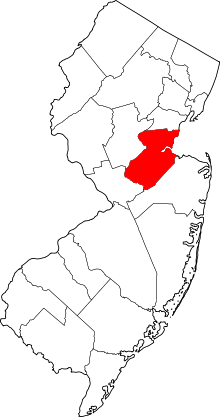
 Cranbury Station, New Jersey  Cranbury Station, New Jersey  Cranbury Station, New Jersey Location of Cranbury Station in Middlesex County Inset: Location of county within the state of New Jersey | |
| Coordinates: 40°18′07″N 74°29′31″W / 40.30194°N 74.49194°WCoordinates: 40°18′07″N 74°29′31″W / 40.30194°N 74.49194°W | |
| Country |
|
| State |
|
| County | Middlesex |
| Township | Cranbury |
| Elevation[1] | 121 ft (37 m) |
| GNIS feature ID | 875706[1] |
.jpg)
.jpg)
Cranbury Station is an unincorporated community located within Cranbury Township in Middlesex County, New Jersey, United States.[2] The area immediately around the site of the former railroad station along the Camden and Amboy Railroad contains agricultural businesses and small homes. Hightstown-Cranbury Station Road is the main road through the settlement paralleling the railroad and Station Road, County Route 615 as a major road heading east and west through the area. Modern warehouses line Station Road and the nearby New Jersey Turnpike west of the station while large housing developments are located east of here in Monroe Township.[3]
References
- 1 2 "Cranbury Station". Geographic Names Information System. United States Geological Survey.
- ↑ Locality Search, State of New Jersey. Accessed February 7, 2015.
- ↑ Google (August 28, 2015). "Aerial view of Cranbury Station" (Map). Google Maps. Google. Retrieved August 28, 2015.