Indiana State Road 59
| ||||
|---|---|---|---|---|
 | ||||
| Route information | ||||
| Maintained by INDOT | ||||
| Length: | 79.53 mi[1] (127.99 km) | |||
| Existed: | October 1, 1926[2] – present | |||
| Major junctions | ||||
| South end: |
| |||
|
| ||||
| North end: |
| |||
| Location | ||||
| Counties: | Clay, Greene, Knox, Montgomery, Parke | |||
| Highway system | ||||
| ||||

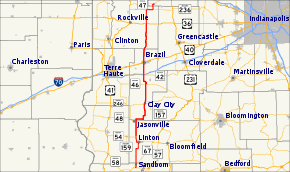
State Road 59 is a north–south road in Central Indiana that covers a distance of about 80 miles (130 km) through five counties.
Route description
State Road 59 begins at State Road 58 (SR 58) and heads north towards Sandborn. In Sandborn SR 59 has intersection with State Road 67 (SR 67). Then SR 59 heads north towards Linton where SR 59 is concurrenct with State Road 54 (SR 54). Both route leave Linton on the northwest side of town. Then north of Linton SR 54 turns west toward Dugger. SR 59 heads north passing through the east side of Jasonville. SR 59 heads north from Jasonville towards Clay City where SR 59 has a concurrency with State Road 246. During the concurrency there is an intersection with State Road 157 in downtown Clay City. SR 59 heads north from Clay City toward Brazil, on the way to Brazil SR 59 passes under Interstate 70. In Brazil SR 59 has an intersection with U.S. Route 40 (US 40). SR 59 leaves Brazil heading north toward Waveland, passing through an intersection with U.S. Route 36 and a concurrency with State Road 236. In Waveland SR 59 enters from the south and has an intersection with State Road 47.[3]
History
From 1917 to 1926 SR 59 was number as State Road 9, from Linton to Brazil, after 1926 renumbering this route became part of SR 59.[4]
Major intersections
| County | Location | mi[1] | km | Destinations | Notes |
|---|---|---|---|---|---|
| Knox | Vigo Township | 0.00 | 0.00 | Southern terminus of SR 59 | |
| Sandborn | 1.62 | 2.61 | |||
| Greene | Linton | 11.84 | 19.05 | Southern end of SR 54 concurrency | |
| 14.66 | 23.59 | Northern end of SR 54 concurrency | |||
| Jasonville | 21.50 | 34.60 | |||
| Clay | Clay City | 32.25 | 51.90 | Southern end of SR 246 concurrency | |
| Northern terminus of SR 157 | |||||
| 33.76 | 54.33 | Northern end of SR 246 concurrency | |||
| Sugar Ridge Township | 41.08 | 66.11 | |||
| Posey Township | 45.89 | 73.85 | |||
| 46.13 | 74.24 | exit number 23 on I-70 | |||
| Brazil | 51.27 | 82.51 | |||
| Parke | Union Township | 67.91 | 109.29 | ||
| Greene Township | 73.92 | 118.96 | Western end of SR 236 concurrency | ||
| 76.53 | 123.16 | Eastern end of SR 236 concurrency | |||
| Montgomery | Waveland | 79.53 | 127.99 | Northern terminus of SR 59 | |
1.000 mi = 1.609 km; 1.000 km = 0.621 mi
| |||||
References
- 1 2 "INDOT Roadway Referencing System" (PDF). staff.
- ↑ "Road Numbers to Be Changed". The Hancock-Democrat. The Indianapolis News. September 30, 1926. Retrieved June 9, 2016 – via Newspapers.com.

- ↑ Google (2011-02-19). "overview map of SR 59" (Map). Google Maps. Google. Retrieved 2011-02-19.
- ↑ "Indiana Highways Ends - Old SR 9". Retrieved 2011-02-19.