Manicouagan crater

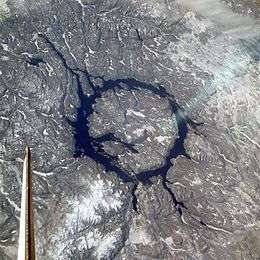 The crater in winter, photographed by Space Shuttle mission STS-9 in 1983 (north is to the lower right). | |
| Impact crater/structure | |
|---|---|
| Confidence | Confirmed[1] |
| Diameter | 100 kilometres (62 mi) |
| Age | 214 ± 1 million years old (Triassic Period) |
| Exposed | Yes |
| Drilled | Yes |
| Location | |
| Location | Rivière-aux-Outardes / Rivière-Mouchalagane, Quebec |
| Coordinates | 51°23′N 68°42′W / 51.383°N 68.700°WCoordinates: 51°23′N 68°42′W / 51.383°N 68.700°W |
| Country | Canada |
 Manicouagan crater Location of the Manicouagan crater in Quebec | |
| Topo map | Canada NTS 22N |
| Access | Quebec Route 389 |
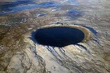
The Manicouagan Crater is one of the oldest known impact craters and is the largest 'visible' impact crater on Earth, located primarily in Manicouagan Regional County Municipality in the Côte-Nord region of Québec, Canada,[1] about 300 km (190 mi) north of the city of Baie-Comeau. At roughly 213-215 million years old, Manicouagan is one of the oldest large astroblemes still visible on the surface. Its northernmost part is located in Caniapiscau Regional County Municipality.
It is thought to have been caused by the impact of a 5 km (3 mi) diameter asteroid or comet about 215.5 million years ago (Triassic Period).[2][3] It was once considered to be associated with the end-Carnian extinction event.
The crater is a multiple-ring structure about 100 km (60 mi) across, with its 70 km (40 mi) diameter inner ring its most prominent feature. It also contains a 70 km (40 mi) diameter annular lake – the Manicouagan Reservoir – surrounding an inner island plateau called René-Levasseur Island. It is the earth's sixth-largest confirmed impact crater according to rim-to-rim diameter.[4]
Hypothetical multiple impact event
It has been suggested that the Manicouagan crater may have been part of a multiple impact event which also formed the Rochechouart crater in France, Saint Martin crater in Manitoba, Obolon' crater in Ukraine, and Red Wing crater in North Dakota. Geophysicist David Rowley of the University of Chicago, working with John Spray of the University of New Brunswick and Simon Kelley of the Open University, discovered that the five craters appeared to form a chain, indicating the breakup and subsequent impact of an asteroid or comet,[5] similar to the well observed string of impacts of Comet Shoemaker-Levy 9 on Jupiter in 1994.[6]
See also
- Manicouagan Reservoir
- List of impact craters on Earth
- List of unconfirmed impact craters on Earth – for unconfirmed craters similar to or larger than Manicouagan
- Wembo-Nyama ring structure
Notes
- 1 2 "Manicouagan". Earth Impact Database. University of New Brunswick. Retrieved 2009-08-19.
- ↑ Hodych, J.P.; G.R.Dunning (1992). "Did the Manicouagan impact trigger end-of-Triassic mass extinction?". Geology. 20: 51.54. Bibcode:1992Geo....20...51H. doi:10.1130/0091-7613(1992)020<0051:DTMITE>2.3.CO;2.
- ↑ Ramezani, J., S. A. Bowring, M. S. Pringle, F. D. Winslow, III, and E. T. Rasbury (2005). "The Manicouagan impact melt rock: a proposed standard for intercalibration of U-Pb and 40Ar/39Ar isotopic systems". 15th V.M. Goldsmidt Conference Abstract Volume, p. A321.
- ↑ "Impact Structures listed by Diameter (Increasing)". PASSC. Retrieved 6 July 2012.
- ↑ Spray, J.G., Kelley, S.P. and Rowley, D.B. (1998). "Evidence for a late Triassic multiple impact event on Earth". Nature, v. 392, pp. 171-173. Abstract
- ↑ Steele, Diana (19 March 1998). "Crater chain points to impact of fragmented comet". University of Chicago Chronicle.
7. Martin Schmieder, Fred Jourdan, Eric Tohver & Edward A. Cloutis (2014): 40Ar/39Ar age of the Lake Saint Martin impact structure (Canada) – Unchaining the Late Triassic terrestrial impact craters – Earth and Planetary Science Letters 406, 37–48.
External links
- Aerial exploration of the Manicouagan crater.
- Rowley, David. "Paleogeographic Atlas Project: Pictures". Paleogeographic Atlas Project. University of Chicago. Archived from the original on 18 June 2007. Retrieved 14 June 2013.