List of impact craters on Earth
This list of impact craters on Earth contains a selection of the 190 confirmed craters given in the Earth Impact Database.[1] To keep the lists manageable, only the largest craters within a time period are included. The complete list is divided into separate articles by geographical region.
The Giant-impact hypothesis is a theory that the moon was the largest impact crater on the Earth between 4.4 and 4.45 billion years ago. Because it happened so long ago, there is little direct visual evidence. It was not taken seriously as a theory until the moon landings.
Confirmed impact craters listed by size and age
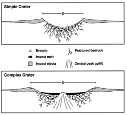
These features were caused by the collision of large meteorites or comets with the Earth. For eroded or buried craters, the stated diameter typically refers to the best available estimate of the original rim diameter, and may not correspond to present surface features. Time units are either in kiloannum (ka) or megaannum (Ma).
Young craters (10 ka or less)
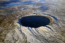
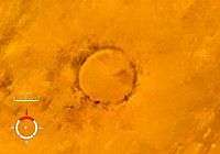
Less than ten thousand years old, and with a diameter of 0.1 km (100 meters) or more. The EID lists only 7 or 8 such craters, and the largest in the last 100,000 years is the 4.5 km Rio Cuarto crater in Argentina,[2] though there is some uncertainty regarding its origins[3] and age, with some sources giving it as < 10 ka[2][4] while the EID gives a broader < 100 ka.[3]
The Kaali impacts (c. 2000 BC) during the Iron Age may have influenced Estonian and Finnish mythology,[5] the Campo del Cielo (c. 2000 BC) could be in the legends of some Native American tribes,[6][7] while Henbury (c. 2200 BC) has figured in Australian aboriginal oral traditions.[8]

| Name | Location | Country | Diameter (approx. in km) |
Age (thousand years) |
Date | Coordinates |
|---|---|---|---|---|---|---|
| Wabar | Rub' al Khali desert | Saudi Arabia | 0.1 | 0.2 | ~1800 AD | 21°30′N 50°28′E / 21.500°N 50.467°E |
| Kaali | Saaremaa | Estonia | 0.1 | 4.0 | 2000 BC | 58°24′N 22°40′E / 58.400°N 22.667°E |
| Campo del Cielo | Chaco | Argentina | 0.1[7] | 4.0 | 2000 BC | 27°38′S 61°42′W / 27.633°S 61.700°W |
| Henbury | Northern Territory | Australia | 0.2 | 4.2 | 2200 BC | 24°34′S 133°8′E / 24.567°S 133.133°E |
| Morasko | Stare Miasto | Poland | 0.1 | 5.0[9] | 3000 BC | 52°29′N 16°54′E / 52.483°N 16.900°E |
| Boxhole | Northern Territory | Australia | 0.2 | 5.4 | 3400 BC | 22°37′S 135°12′E / 22.617°S 135.200°E |
| Macha | Sakha Republic | Russia | 0.3 | 7.3 | 5300 BC | 60°6′N 117°35′E / 60.100°N 117.583°E |
| Rio Cuarto | Córdoba Province | Argentina | 4.5 | <10[2][4] | <8000 BC | 32°52.7′S 64°13.4′W / 32.8783°S 64.2233°W |
The EID gives a size of about 50 meters for Campo del Cielo, but other sources quote 100 meters.[7]
Large craters (10 ka to 1 Ma)
From between 10 thousand years to 1 million years ago, and with a diameter of 1 km or more. The largest in the last one million years is the 14-km Zhamanshin crater in Kazakhstan and has been described as being capable of producing a nuclear-like winter.[10]
However, if the source of the enormous Australasian strewnfield (c. 780 ka) will be found, it is suggested it could be a crater about 100 km across.[11][12]
| Name | Location | Country | Diameter (km) | Age (thousand years) | Coordinates |
|---|---|---|---|---|---|
| Tenoumer | Sahara Desert | Mauritania | 1.9 | 21 | 22°55′5″N 10°24′27″W / 22.91806°N 10.40750°W |
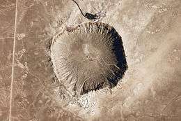
| Meteor Crater | Arizona | United States | 1.2 | 49 | 35°2′N 111°1′W / 35.033°N 111.017°W |
| Xiuyan | Xiuyan | China | 1.8 | 50 | 40°21′N 123°27′E / 40.350°N 123.450°E |
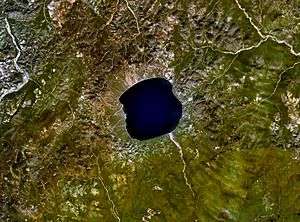
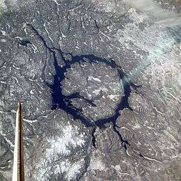
| Lonar | Maharashtra | India | 1.8 | 52 | 19°58′N 76°31′E / 19.967°N 76.517°E |
| Agoudal[13] | Atlas Mountains | Morocco | 3.0 | 105 | 31°59′N 5°30′W / 31.983°N 5.500°W |
| Tswaing | Pretoria Saltpan | South Africa | 1.1 | 220 | 25°24′32″S 28°4′58″E / 25.40889°S 28.08278°E |
| Zhamanshin | Kazakhstan | Kazakhstan | 14.0 | 900 ± 100 | 48°24′N 60°58′E / 48.400°N 60.967°E |
Larger craters (1 Ma to 10 Ma)

From between 1 and 10 million years ago, and with a diameter of 5 km or more. If uncertainties regarding its age are resolved, then the largest in the last 10 million years would be the 52-km Karakul crater which is listed in EID with an age of less than 5 Ma, or the Pliocene. The large but apparently craterless Eltanin impact (2.5 Ma) into the Pacific Ocean has been suggested as contributing to the glaciations and cooling during the Pliocene.[14]
| Name | Location | Country | Diameter (km) | Age (million years) | Coordinates |
|---|---|---|---|---|---|
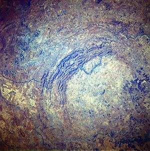
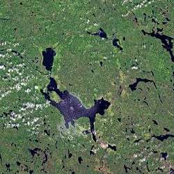
| Bosumtwi | Ashanti | Ghana | 10 | 1.1 | 6°30.3′N 1°24.5′W / 6.5050°N 1.4083°W |
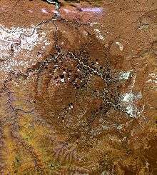
| Elgygytgyn | Chukotka Autonomous Okrug | Russia | 18 | 3.5 | 67°30′N 172°00′E / 67.500°N 172.000°E |
| Bigach | Kazakhstan | Kazakhstan | 8 | 5.0 | 48°34′N 82°1′E / 48.567°N 82.017°E |
| Karla | Tatarstan | Russia | 10 | 5.0 | 54°55′N 48°2′E / 54.917°N 48.033°E |
| Karakul | Pamir Mountains | Tajikistan | 52 | <5?[15][16] | 39°1′N 73°27′E / 39.017°N 73.450°E |
Largest craters (10 Ma or more)
Craters with a diameter of 20 km or more are all older than 10 Ma, with the exception of Karakul which seems to have an uncertain age. There are more than forty such craters. The largest two within the last hundred million years have been linked to two extinction events: Chicxulub for the Cretaceous–Paleogene and the Popigai impact for the Eocene–Oligocene extinction event.[17]


Large unconfirmed craters
The largest unconfirmed craters 200 km or more are significant not only for their size, but also for the possible coeval events associated with them. For example, the Wilkes Land crater has been connected to the massive Permian–Triassic extinction event.[18]
| Name | Location | Country | Diameter (km) | Age (million years) | Coordinates |
|---|---|---|---|---|---|
| Australian impact structure | Northern Territory | Australia | 600 | 545 | |
| Shiva crater | offshore of India | India | 500 | 65 | |
| Wilkes Land crater | Wilkes Land | Antarctica | 480-500 | 250-500 | |
| Nastapoka arc | Nunavut/Quebec | Canada | 450 | unknown | 57°00′N 78°50′W / 57.000°N 78.833°W| |
| Ishim impact structure[19] | Akmola Region | Kazakhstan | 300 | 460-430[20] | 52°0′N 69°0′E / 52.000°N 69.000°E |
| Bedout | offshore of Western Australia | Australia | 250 | 250 | |
| East Warburton Basin | Southern Australia | Australia | 200+ | 300-360 |
All craters listed alphabetically
As of 2016, the Earth Impact Database (EID) contains 190 confirmed craters. The table below is arranged by the continent's percentage of the Earth's land area, and where Asian and Russian craters are grouped together per EID convention. The global distribution of known impact structures apparently shows a surprising asymmetry,[21] with the small but well-funded European continent having a large percentage of confirmed craters. It is suggested this situation is an artifact, highlighting the importance of intensifying research in less studied areas like South America and elsewhere.[21]
.svg.png)
.svg.png)
.svg.png)
.svg.png)
.svg.png)
| Continent | Continent's % of Earth's land area | Continent's % of known craters | Number of craters |
|---|---|---|---|
| Asia & Russia | 30% | 16% | 31 |
| Africa | 20% | 10% | 20 |
| North America | 16% | 32% | 60 |
| South America | 12% | 6% | 11 |
| Antarctica | 9% | 0% | 0 |
| Europe | 7% | 22% | 41 |
| Australia | 6% | 14% | 27 |
| Total | 100% | 100% | 188 |
- List of impact craters in Asia and Russia
- List of impact craters in Africa
- List of impact craters in North America
- List of impact craters in South America
- List of impact craters in Antarctica
- List of impact craters in Europe
- List of impact craters in Australia
See also
- Bolides
- Earth Impact Database
- Extinction event
- Impact events
- Impact Field Studies Group
- List of unconfirmed impact craters on Earth
- Traces of Catastrophe book from Lunar and Planetary Institute - comprehensive reference on impact crater science
- Giant-impact hypothesis
References
- ↑ "Earth Impact Database".
- 1 2 3 P. Bland et al. (2002). A possible tektite strewn field in the Argentinian Pampa, Science, Volume 296, Issue 5570, pp. 1109-1112
- 1 2 "Rio Cuarto". Earth Impact Database. University of New Brunswick. Retrieved 2009-08-19.
- 1 2 P. Schultz and R. Lianza (1992). "Recent grazing impacts on the Earth recorded in the Rio Cuarto crater field, Argentina", Nature 355, p. 234-237 (16 January 1992)
- ↑ Haas, Ain; Andres Peekna; Robert E. Walker. "ECHOES OF ANCIENT CATACLYSMS IN THE BALTIC SEA" (PDF). Electronic Journal of Folklore. Retrieved 2008-10-26.
- ↑ Giménez Benítez; et al. "Meteorites of Campo del Cielo: Impact on the indian culture".
- 1 2 3 Peter T. Bobrowsky, Hans Rickman (2007). Comet/asteroid impacts and human society: an interdisciplinary approach. Springer. pp. 30–31. ISBN 3-540-32709-6.
- ↑ Duane W. Hamacher; John Goldsmith. "Aboriginal oral traditions of Australian impact craters" (PDF).
- ↑ Wojciech Stankowski, Anto Raukas, Andrzej Bluszcz, and Stanisław Fedorowicz. "Luminescence dating of the Morasko (Poland), Kaali, Ilumetsa, and Tsõõrikmäe (Estonia) meteorite craters" (PDF).
- ↑ Essay "Impact Cratering on Earth", based on: R.A.F. Grieve, 1990, Impact cratering on the Earth, Scientific American, v. 262, 66-73.
- ↑ Povenmire H., Liu W. and Xianlin I. (1999) "Australasian tektites found in Guangxi Province, China,"] 30th Annual Lunar and Planetary Science Conference, Houston, March 1999.
- ↑ Glass B.P. and Pizzuto J.E. (1994) "Geographic variation in Australasian microtektite concentrations: Implications concerning the location and size of the source crater," J of Geophysical Research, vol 99, no E9, 19075-19081, Sept 1994.
- ↑ "Agoudal". Earth Impact Database. University of New Brunswick. Retrieved 2016-08-18.
- ↑ University of New South Wales (19 September 2012). "Did a Pacific Ocean meteor trigger the Ice Age?". Retrieved 8 October 2012.
- ↑ "Kara-Kul". Earth Impact Database. University of New Brunswick. Retrieved 2009-08-15.
- ↑ Gurov, E. P., Gurova, H.P., Rakitskaya, R.B. and Yamnichenko,A.Yu. (1993). "The Karakul depression in Pamirs - the first impact structure in central Asia" (PDF). Lunar and Planetary Science XXIV, pp. 591-592.
- ↑ "Russia's Popigai Meteor Crash Linked to Mass Extinction". June 13, 2014.
- ↑ Gorder, Pam Frost (June 1, 2006). "Big Bang in Antarctica – Killer Crater Found Under Ice". Ohio State University Research News.
- ↑ Frank Dachille. "Frequency of the formation of large terrestrial impact craters".
- ↑ Zeylik B. S.; Seytmuratova E. Yu, 1974: A meteorite-impact structure in central Kazakhstan and its magmatic-ore controlling role. Doklady Akademii Nauk SSSR: 1, Pages 167-170
- 1 2 Prezzi, C.; Orgeira, M.; Acevedo, R. et al (2011). Geophysical characterization of two circular structures at Bajada del Diablo (Patagonia, Argentina): Indication of impact origin, Physics of the Earth and Planetary Interiors, Volume 192, p. 21-34.
External links
- Impact Database (formerly Suspected Earth Impact Sites list) maintained by David Rajmon for Impact Field Studies Group, USA
- Impact Meteor Crater Viewer Google Maps Page with Locations of Meteor Craters around the world