List of impact craters in Europe

This list includes all 41 of confirmed impact craters in Europe as listed in the Earth Impact Database (EID). These features were caused by the collision of large meteorites or comets with the Earth. For eroded or buried craters, the stated diameter typically refers to an estimate of original rim diameter, and may not correspond to present surface features. By EID convention, Russian and Asian craters are grouped together in the List of impact craters in Asia and Russia.
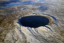
Name Location Diameter (km) Age (years) Coordinates
Boltysh Ukraine 24 65.17 ± 0.64 million 48°45′N 32°10′E / 48.750°N 32.167°E / 48.750; 32.167 (Boltysh)
Dellen Sweden 19 89.0 ± 2.7 million 61°51′N 16°42′E / 61.850°N 16.700°E / 61.850; 16.700 (Dellen)
Dobele Latvia 4.5 290 ± 35 million 56°35′N 23°15′E / 56.583°N 23.250°E / 56.583; 23.250 (Dobele)
Gardnos Norway 5 500 ± 10 million 60°39′N 9°0′E / 60.650°N 9.000°E / 60.650; 9.000 (Gardnos)
Granby Sweden 3 470 million (approx.) 58°25′N 14°56′E / 58.417°N 14.933°E / 58.417; 14.933 (Granby)
Ilumetsa Estonia 0.08 6600 (at least) 57°58′N 27°25′E / 57.967°N 27.417°E / 57.967; 27.417 (Ilumetsa)
Hummeln structure Sweden 1.2 443-470 million (approx.) 57°22′N 16°15′E / 57.367°N 16.250°E / 57.367; 16.250
Ilyinets Ukraine 8.5 378 ± 5 million 49°7′N 29°6′E / 49.117°N 29.100°E / 49.117; 29.100 (Ilyinets)
Iso-Naakkima Finland 3 1000 million (at least) 62°11′N 27°9′E / 62.183°N 27.150°E / 62.183; 27.150 (Iso-Naakkima)
Kaali Estonia 0.11 km (largest of 9) 3000...5000 58°22′N 22°40′E / 58.367°N 22.667°E / 58.367; 22.667 (Kaali)
Kärdla Estonia 4 455 million (approx.) 59°1′N 22°46′E / 59.017°N 22.767°E / 59.017; 22.767 (Kärdla)
Karikkoselkä Finland 1.4 230 million (approx.) 62°13′N 25°15′E / 62.217°N 25.250°E / 62.217; 25.250 (Karikkoselkä)
Keurusselkä Finland 30 1800 million (at most) 62°8′N 24°36′E / 62.133°N 24.600°E / 62.133; 24.600 (Keurusselkä)
Lappajärvi Finland 23 73.3 ± 5.3 million 63°12′N 23°42′E / 63.200°N 23.700°E / 63.200; 23.700 (Lappajärvi)
Lockne Sweden 7.5 458 million (approx.) 63°0′N 14°49′E / 63.000°N 14.817°E / 63.000; 14.817 (Lockne)
Logoisk Belarus 15 42.3 ± 1.1 million 54°12′N 27°48′E / 54.200°N 27.800°E / 54.200; 27.800 (Logoisk)
Lumparn Finland 9 1000 million (approx.) 60°9′N 20°6′E / 60.150°N 20.100°E / 60.150; 20.100 (Lumparn)
Malingen Sweden 1 458 million (approx.) 62°55′N 14°33′E / 62.917°N 14.550°E / 62.917; 14.550
Mien Sweden 9 121.0 ± 2.3 million 56°25′N 14°52′E / 56.417°N 14.867°E / 56.417; 14.867 (Mien)
Mizarai Lithuania 5 500 ± 20 million 54°1′N 23°54′E / 54.017°N 23.900°E / 54.017; 23.900 (Mizarai)
Mjølnir Barents Sea, Norway 40 142.0 ± 2.6 million 73°48′N 29°40′E / 73.800°N 29.667°E / 73.800; 29.667 (Mjølnir)
Morasko Poland 0.10 km (largest of 7) ~10000 52°29′N 16°54′E / 52.483°N 16.900°E / 52.483; 16.900 (Morasko)
Neugrund Estonia 8 470 million (approx.) 59°20′N 23°40′E / 59.333°N 23.667°E / 59.333; 23.667 (Neugrund)
Nördlinger Ries Germany 25 14.8 million 48°53′N 10°34′E / 48.883°N 10.567°E / 48.883; 10.567 (Nördlinger Ries)
Obolon' Ukraine 20 169 ± 7 million 49°35′N 32°55′E / 49.583°N 32.917°E / 49.583; 32.917 (Obolon')
Paasselkä Finland 10 1800 million (at most) 62°9′N 29°25′E / 62.150°N 29.417°E / 62.150; 29.417 (Paasselkä)
Ritland crater Norway 2.7 520 ± 20 59°14′N 6°26′E / 59.233°N 6.433°E / 59.233; 6.433
Rochechouart France 23 214 ± 8 million 45°49′N 0°47′E / 45.817°N 0.783°E / 45.817; 0.783 (Rochechouart)
Rotmistrovka Ukraine 2.7 120 ± 10 million 49°0′N 32°0′E / 49.000°N 32.000°E / 49.000; 32.000 (Rotmistrovka)
Saarijärvi Finland 1.5 600 million (at least) 65°17′N 28°23′E / 65.283°N 28.383°E / 65.283; 28.383 (Saarijärvi)
Siljan Sweden 52 376.8 ± 1.7 million 61°2′N 14°52′E / 61.033°N 14.867°E / 61.033; 14.867 (Siljan)
Steinheim Germany 3.8 15 ± 1 million 48°41′N 10°4′E / 48.683°N 10.067°E / 48.683; 10.067 (Steinheim)
Suvasvesi North Finland 4 1000 million (at most) 62°42′N 28°10′E / 62.700°N 28.167°E / 62.700; 28.167 (Suvasvesi North)
Suvasvesi South Finland 3.8 250 million (approx.) 62°36′N 28°13′E / 62.600°N 28.217°E / 62.600; 28.217 (Suvasvesi South)
Sääksjärvi Finland 6 560 million (approx.) 61°24′N 22°24′E / 61.400°N 22.400°E / 61.400; 22.400 (Sääksjärvi)
Söderfjärden Finland 6.6 600 million (approx.) 63°0′N 21°34′E / 63.000°N 21.567°E / 63.000; 21.567 (Söderfjärden)
Ternovka Ukraine 11 280 ± 10 million 48°08′N 33°31′E / 48.133°N 33.517°E / 48.133; 33.517 (Ternovka)
Tvären Sweden 2 455 million (approx.) 58°46′N 17°25′E / 58.767°N 17.417°E / 58.767; 17.417 (Tvären)
Vepriai Lithuania 8 160 ± 10 million (at least) 55°5′N 24°35′E / 55.083°N 24.583°E / 55.083; 24.583 (Vepriai)
Zapadnaya Ukraine 3.2 165 ± 5 million 49°44′N 29°0′E / 49.733°N 29.000°E / 49.733; 29.000 (Zapadnaya)
Zeleny Gai Ukraine 3.5 80 ± 20 million 48°4′N 32°45′E / 48.067°N 32.750°E / 48.067; 32.750 (Zeleny Gai)

Unconfirmed impact craters

The following craters are officially considered "unconfirmed" because they are not listed in the Earth Impact Database. Due to stringent requirements regarding evidence and peer-reviewed publication, newly discovered craters or those for which it is difficult to collect evidence are generally known for some time before becoming listed. However, entries on the unconfirmed list could still have an impact origin disproven.

Name Location Diameter Age Coordinates
Guarda Portugal 30 200 million (approx.) 40°38′N 07°06′W / 40.633°N 7.100°W / 40.633; -7.100 (Guarda)
Silverpit North Sea near England 20[1] 60 ± 15 million 54°14′N 1°51′E / 54.233°N 1.850°E / 54.233; 1.850 (Silverpit)
Sirente Italy largest 140 x 115 m 1700 years (approx.) 42°10′38″N 13°35′45″E / 42.17722°N 13.59583°E / 42.17722; 13.59583 (Sirente)
Ullapool Loch Broom, Scotland 50 1.2 billion 57°09′N 5°17′W / 57.150°N 5.283°W / 57.150; -5.283 (Ullapool)
Zerelia East[2] Thessaly, Greece 150 m at least 7000 years 39°09′43″N 22°42′51″E / 39.16194°N 22.71417°E / 39.16194; 22.71417 (Zerelia East)
Zerelia West[2] Thessaly, Greece 250 m at least 7000 years 39°09′48″N 22°42′32″E / 39.16333°N 22.70889°E / 39.16333; 22.70889 (Zerelia West)

See also

References

  1. Stewart SA, Allen PJ (2002). "A 20-km-diameter multi-ringed impact structure in the North Sea". Nature. 418 (6897): 520–3. Bibcode:2002Natur.418..520S. doi:10.1038/nature00914. PMID 12152076.
  2. 1 2 "The enigmatic Zerelia twin-lakes (Thessaly, Central Greece): two potential meteorite impact Craters". Solid Earth Discussions. 5: 1511–1573. 2013. Bibcode:2013SolED...5.1511D. doi:10.5194/sed-5-1511-2013.

External links

This article is issued from Wikipedia - version of the 7/16/2016. The text is available under the Creative Commons Attribution/Share Alike but additional terms may apply for the media files.