Manicouagan Reservoir
| Manicouagan Reservoir | |
|---|---|
 View from orbit (Image courtesy NASA) | |
| Location | Rivière-aux-Outardes, Manicouagan Regional County Municipality / Rivière-Mouchalagane, Caniapiscau Regional County Municipality, Quebec |
| Coordinates | 51°23′N 68°42′W / 51.383°N 68.700°WCoordinates: 51°23′N 68°42′W / 51.383°N 68.700°W |
| Lake type | annular lake, reservoir, impact crater lake |
| Primary outflows | Manicouagan River |
| Catchment area | 29,241 km2 (11,290 sq mi) |
| Basin countries | Canada |
| Surface area | 1,942 km2 (750 sq mi) |
| Average depth | 85 m (279 ft) |
| Max. depth | 350 m (1,150 ft) |
| Water volume | 139.8 km3 (113,300,000 acre·ft)[1] |
| Residence time | 8 years |
| Shore length1 | 1,322 km (821 mi) |
| Surface elevation | 342 to 359 m (1,122 to 1,178 ft) (Dates: 1980 to 2005) |
| Islands | René-Levasseur Island |
| 1 Shore length is not a well-defined measure. | |
Manicouagan Reservoir (also Lake Manicouagan) is believed to have been caused by the impact of a meteor of 5 kilometres diameter, producing the annular lake (ringlike lake) in central Quebec, Canada. The lake covers an area of 1,942 km², and its eastern shore is accessible via Route 389. The lake island in the centre of the lake is known as René-Levasseur Island, and its highest point is Mount Babel. The lake and island are clearly seen from space and are sometimes called the "eye of Quebec." With a volume of 139.8 cubic kilometres (33.5 cu mi), the reservoir itself is the fifth largest in the world by volume, although only 35.2 cubic kilometres (8.4 cu mi) can be used for hydro-electric power production.[1][2] In 2007, astronaut Marc Garneau nominated the reservoir for the CBC's Seven Wonders of Canada competition.
Manicouagan impact crater
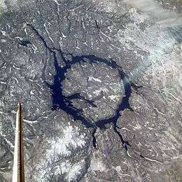
Manicouagan Reservoir lies within the remnant of an ancient eroded impact crater (astrobleme). The crater was formed following the impact of an asteroid with a diameter of 5 kilometres (3.1 mi), which excavated a crater originally about 100 km (62 mi) wide, although erosion and deposition of sediments have since reduced the visible diameter to about 72 km (45 mi). It is the sixth-largest confirmed impact crater known on earth.[3] Mount Babel is interpreted as the central peak of the crater, formed by post-impact uplift.
Research has shown that impact melt within the crater has an age of 214±1 million years. As this is 12±2 million years before the end of the Triassic, the impact that produced the crater cannot have been the cause of the Triassic–Jurassic extinction event.[4]
Hydroelectric project

The lake was enlarged by flooding the earlier Lake Mouchalagane[5] and Manicouagan by construction of the Daniel-Johnson Dam, part of the massive Manicouagan or Manic series of hydroelectric projects undertaken by Hydro-Québec, the provincial electrical utility, during the 1960s. The complex of dams is also called the Manic-Outardes Project because the rivers involved are the Manicouagan and the Outardes.
The Manicouagan Reservoir acts as a giant headpond for the Manicouagan River, feeding the Manic-2, Manic-3, and Manic-5 generating stations downstream. In the peak period of the winter cold, the lake surface is usually lower, since the turbines run all the time at peak load to meet the massive electrical heating needs of the province. The surface of the lake also experiences low levels in the extreme periods of heat in New England during the summer, since in that period Hydro-Québec sells electrical energy to the joint New England grid and individual utilities in the United States.
See also
References
- 1 2 Hydro-Québec - Cinq principaux réservoirs d'Hydro-Québec
- ↑ Briney, Amanda. "The World's Top Ten Largest Reservoirs by Volume". About.com. Retrieved 19 August 2010.
- ↑ Earth Impact Database
- ↑ Hodych, J.P.; G.R.Dunning (1992). "Did the Manicouagan impact trigger end-of-Triassic mass extinction?". Geology. 20: 51.54. Bibcode:1992Geo....20...51H. doi:10.1130/0091-7613(1992)020<0051:DTMITE>2.3.CO;2.
- ↑ http://ottawa-rasc.ca/wiki/index.php?title=Odale-Articles-Manicouagan
External links
| Wikimedia Commons has media related to Daniel-Johnson Dam. |
- Earth Impact Database
- Aerial Exploration of the Manicouagan Structure
- World Lakes Database Manicouagan Reference