Carswell crater
|
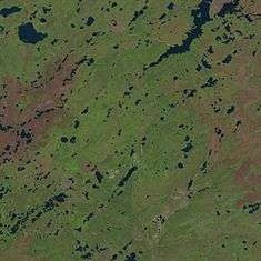
In the northern part the rim is visible as a series of low hills, in the southern part it is indicated by the course of Douglas River. Carswell Lake (in the upper right) cuts into the crater. | |
| Impact crater/structure | |
|---|---|
| Diameter | 39 kilometres (24 mi) |
| Age | 115 ± 10 million years (Lower Cretaceous) |
| Exposed | Yes |
| Drilled | Yes |
| Location | |
| Coordinates | 58°26′26″N 109°30′24″W / 58.44056°N 109.50667°WCoordinates: 58°26′26″N 109°30′24″W / 58.44056°N 109.50667°W |
| Country | Canada |
| Province | Saskatchewan |
 Carswell crater Location of Carswell crater in Saskatchewan | |
| Topo map | NTS 74K5, 74K6 |
| Access | Saskatchewan Highway 955 |
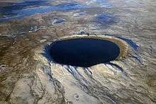
Carswell is an impact crater within the Athabasca Basin of the Canadian Shield in northern Saskatchewan, Canada.[1] It is 39 kilometres (24 mi) in diameter and the age is estimated to be 115 ± 10 million years (Lower Cretaceous). The crater is exposed at the surface.
Access
The Carswell Crater can be reached by Saskatchewan Highway 955. The 245 kilometres (152 mi) gravel road begins in the village of La Loche and ends at the old Cluff Lake mine site within the crater. The Cluff Lake uranium mine produced over 62 million pounds of yellowcake during its 22-year operating life.[2]
See also
References
- ↑ "Carswell". Earth Impact Database. University of New Brunswick. Retrieved 2008-12-30.
- ↑ "Comprehensive Study Report - Cluff Lake Decommissioning Project" (PDF). Canadian Nuclear Safety Commission. December 2003. Retrieved 2013-10-03.
External links
This article is issued from Wikipedia - version of the 9/25/2015. The text is available under the Creative Commons Attribution/Share Alike but additional terms may apply for the media files.