Loreto, Agusan del Sur
| Loreto | |
|---|---|
| Municipality | |
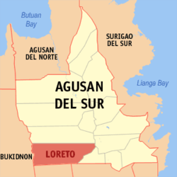 Location within Agusan del Sur province | |
.svg.png) Loreto Location within the Philippines | |
| Coordinates: 8°11′N 125°51′E / 8.19°N 125.85°ECoordinates: 8°11′N 125°51′E / 8.19°N 125.85°E | |
| Country | Philippines |
| Region | Caraga (Region XIII) |
| Province | Agusan del Sur |
| District | 2nd district of Agusan del Sur |
| Founded | March 30, 1965 |
| Barangays | 17 (see Barangays) |
| Government [1] | |
| • Type | Sangguniang Bayan |
| • Mayor | Romeo O. Magadan (acting) |
| Area[2] | |
| • Total | 1,462.74 km2 (564.77 sq mi) |
| Population (2015 census)[3] | |
| • Total | 42,501 |
| • Density | 29/km2 (75/sq mi) |
| • Voter (2016)[4] | 20,898 |
| Time zone | PST (UTC+8) |
| ZIP code | 8507 |
| IDD : area code | +63 (0)85 |
| Income class | 1st class |
| PSGC | 160305000 |
Loreto, officially the Municipality of Loreto (Filipino: Bayan ng Loreto), is a municipality in the province of Agusan del Sur in the Caraga (Region XIII) of the Philippines. The population was 42,501 at the 2015 census.[3] In the 2016 election, it had 20,898 registered voters.[4]
History
It was in the year 1600 (please check this date, Fr. Urios came to Agusan in 1880's) when the Spaniards first came to the upper reaches of Agusan and discover the Manobos. In convincing the Manobos to organized themselves and lived in a settlement/community, the settlement was given the name of "Loreto" in remembrance of Fr. Urios town in Spain on March 30, 1965.
Rain of fish
On a rainy morning in January 13, 2012, Loreto became nationally notable when it became the site of a rain of fish. Seventy-two small fish were recovered and placed in an aquarium. They were about 3 in (7.6 cm) long and had small spots, but the species remains unknown. The Bureau of Fisheries and Aquatic Resources attributes the phenomenon to a waterspout.[5][6][7]
Geography
Loreto is located at 8°11′N 125°51′E / 8.19°N 125.85°E.
According to the Philippine Statistics Authority, the municipality has a land area of 1,462.74 square kilometres (564.77 sq mi)[2] constituting 14.64% of the 9,989.52-square-kilometre- (3,856.98 sq mi) total area of Agusan del Sur.
Loreto is a river town situated south-west of Agusan del Sur. It is bounded on the north by La Paz, north-east by Bunawan, and southeast by Veruela. The provinces of Bukidnon and Davao del Norte bound its Western and Southern portions.
Loreto is a strategically situated as a junction point to various destination within Agusan del Sur and nearby provinces. The accessibility of Loreto to Provincial Center, Patin-ay in Prosperidad has three main routes: the Loreto-Santa Josefa-Trento route of 118.36 kilometres (73.55 mi), the Loreto-La Paz Talacogon route of 85.53 kilometres (53.15 mi), and the Loreto-Bunawan route of 87.52 kilometres (54.38 mi) with two hours of Pump boat cruising the Agusan River.
Barangays
Loreto is politically subdivided into 23 barangays.[8]
| PSGC | Barangay | Population | ±% p.a. | ||
|---|---|---|---|---|---|
| 2015[3] | 2010[9] | ||||
| 160305001 | Binucayan | 6.5% | 2,781 | 3,605 | −4.82% |
| 160305002 | Johnson | 3.4% | 1,433 | 1,547 | −1.45% |
| 160305013 | Kasapa | 4.1% | 1,738 | 3,122 | −10.55% |
| 160305014 | Katipunan | 1.2% | 525 | 677 | −4.73% |
| 160305015 | Kauswagan | 5.8% | 2,445 | 2,182 | +2.19% |
| 160305003 | Magaud | 7.8% | 3,314 | 2,303 | +7.18% |
| 160305004 | Nueva Gracia | 5.3% | 2,270 | 1,928 | +3.16% |
| 160305005 | Poblacion | 15.0% | 6,384 | 6,456 | −0.21% |
| 160305017 | Sabud | 10.3% | 4,367 | 779 | +38.85% |
| 160305006 | San Isidro | 3.8% | 1,601 | 1,532 | +0.84% |
| 160305007 | San Mariano | 5.7% | 2,411 | 2,709 | −2.19% |
| 160305008 | San Vicente | 5.1% | 2,163 | 2,227 | −0.55% |
| 160305009 | Santa Teresa | 5.5% | 2,325 | 2,324 | +0.01% |
| 160305016 | Santo Niño | 2.6% | 1,088 | 1,221 | −2.17% |
| 160305010 | Santo Tomas | 9.1% | 3,859 | 3,674 | +0.94% |
| 160305011 | Violanta | 3.4% | 1,439 | 1,174 | +3.95% |
| 160305012 | Waloe | 5.5% | 2,358 | 2,014 | +3.05% |
| Total | 42,501 | 39,474 | +1.42% | ||
Demographics
| Population census of Loreto | |||||||||||||||||||||||||
|---|---|---|---|---|---|---|---|---|---|---|---|---|---|---|---|---|---|---|---|---|---|---|---|---|---|
|
| ||||||||||||||||||||||||
| Source: PSA[3][9][10] | |||||||||||||||||||||||||
In the 2015 census, Loreto had a population of 42,501.[3] The population density was 29 inhabitants per square kilometre (75/sq mi).
In the 2016 election, it had 20,898 registered voters.[4]
References
- ↑ "Municipality". Quezon City, Philippines: Department of the Interior and Local Government. Retrieved 31 May 2013.
- 1 2 "Province: Agusan del Sur". PSGC Interactive. Makati City, Philippines: Philippine Statistics Authority. Retrieved 28 October 2016.
- 1 2 3 4 5 "CARAGA". Census of Population (2015): Total Population by Province, City, Municipality and Barangay (Report). PSA. Retrieved 20 June 2016.
- 1 2 3 "2016 National and Local Elections Statistics". Commission on Elections. 2016.
- ↑ Jereco O. Paloma (January 15, 2012). "Agusan's 'rain of fish' natural although unusual". SunStar Davao. Retrieved January 16, 2012.
- ↑ Lani Nami Buan (January 15, 2012). "'Fish rain' puzzles residents in Agusan Sur's Loreto town". GMA News. Retrieved January 16, 2012.
- ↑ Charmane Awitan (January 13, 2012). "Fish rain down on Agusan del Sur town". ABS-CBN News. Retrieved January 16, 2012.
- ↑ "Municipal: Loreto, Agusan del Sur". PSGC Interactive. Quezon City, Philippines: Philippine Statistics Authority. Retrieved 8 January 2016.
- 1 2 "CARAGA". Census of Population and Housing (2010): Total Population by Province, City, Municipality and Barangay (Report). NSO. Retrieved 29 June 2016.
- ↑ "CARAGA". Census of Population (1995, 2000 and 2007): Total Population by Province, City and Municipality (Report). NSO. Archived from the original on 11 November 2011.
 |
Malaybalay, Bukidnon | La Paz | Bunawan | |
| Cabanglasan, Bukidnon | |
Veruela | ||
| ||||
| | ||||
| San Fernando, Bukidnon | Kapalong, Davao del Norte | Laak, Compostela Valley |
Prosperidad (capital) | |
| Municipalities | |
| Component city | |