Agusan River
| Agusan River (Suba sa Agusan) | |
| Ilog ng Agusan, Rio Grande de Agusan | |
| River | |
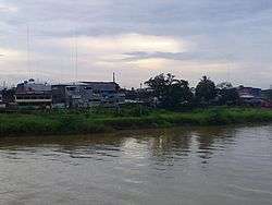 The Agusan River with Butuan City in its view from Magsaysay Bridge. | |
| Country | Philippines |
|---|---|
| Regions | Caraga Region, Davao Region |
| Tributaries | |
| - left | Umayam River, Bansa River, Ojot River, Manat River, Bugabos River |
| - right | Wawa River Adanan River, Gibong River, Choco River in Compostela, Ulip River |
| Cities | Butuan City, Bayugan City |
| Source | Mount Tagubud , Pantukan, Compostela Valley |
| - elevation | 1,022 m (3,353 ft) |
| Mouth | Mouth of Agusan River |
| - location | Butuan Bay |
| - elevation | 0 m (0 ft) |
| - coordinates | PH 8°57′0″N 125°31′58″E / 8.95000°N 125.53278°ECoordinates: PH 8°57′0″N 125°31′58″E / 8.95000°N 125.53278°E |
| Length | 350 km (217.48 mi) |
| Basin | 10,921 km2 (4,216.62 sq mi) |
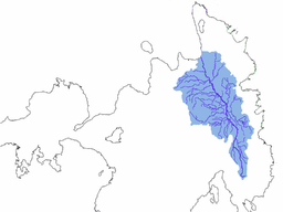 Drainage basin of the Agusan River
| |
Agusan River is a river located in the eastern part of Mindanao island in the Philippines, draining majority of the Caraga Region and some parts of Compostela Valley province. It is the third largest river basin of the Philippines with a total drainage area of 10,921 km² and an estimated length of 350 kilometers from its origin.[1][2] The headwaters of the river is found in the mountains of Compostela Valley, near its border with Davao Oriental and east of Tagum City. It flows through the wide Agusan River valley which measures 177 kilometers (110 mi) from south to north and varies from 32-48 kilometers (20–30 miles) in width.[3] It finally drains into the Butuan Bay at its mouth in Butuan City. The river is also the third longest river in the Philippines.
One of the prominent features in the Agusan River basin is the presence of the Agusan Marsh covering a total area of 19,197 hectares. The marsh serves a flood retention basin for the Agusan River, cutting the high discharge of water causing flash floods in the lower reaches of the river. Aside from that, the marsh harbors unique and pristine habitats like the sago and peat swamps forest and is a home to endangered and endemic flora and fauna. As a consequence, it was declared by former President Fidel V. Ramos as a wildlife sanctuary in 1996.[2]
Geography
Watershed
The Agusan River basin is divided into three sub-basins on the basis of topographic features: upper Agusan River basin, middle Agusan River basin and lower Agusan River basin. The upper Agusan River basin is the section from its headwaters in the mountains of Compostela Valley province to Santa Josefa, Agusan del Sur to Veruela, Agusan del Sur, the middle Agusan River basin is the section of the river from Sta. Josefa to Amparo, Agusan del Sur while the lower Agusan River basin is from Amparo to its mouth at Butuan City, Agusan del Norte
See also
References
- ↑ Kundel, Jim (June 7, 2007). "Water profile of Philippines". Encyclopedia of Earth. Archived from the original on 21 September 2008. Retrieved 2008-09-30.
- 1 2 "Technical Assistance To The Republic of the Philippines For A Master Plan For the Agusan River Basin" (PDF). Asian Development Bank. December 2004. Retrieved 2008-08-09.
- ↑ Plains of Mindanao