Llanidloes
| Llanidloes | |
 |
|
 Llanidloes |
|
| Population | 2,929 [1] |
|---|---|
| OS grid reference | SN954845 |
| – London | 211 miles (340 km) ESE |
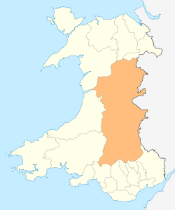
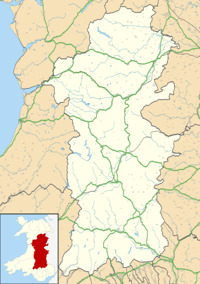
| Principal area | Powys |
| Ceremonial county | Powys |
| Country | Wales |
| Sovereign state | United Kingdom |
| Post town | LLANIDLOES |
| Postcode district | SY18 |
| Dialling code | 01686 |
| Police | Dyfed-Powys |
| Fire | Mid and West Wales |
| Ambulance | Welsh |
| EU Parliament | Wales |
| UK Parliament | Montgomeryshire |
| Welsh Assembly | Montgomeryshire |
Coordinates: 52°26′56″N 3°32′25″W / 52.449°N 3.5402°W
Llanidloes (Welsh pronunciation: [ɬanˈɪdlɔɨs]) is a town along the A470 road and B4518 road in Powys, within the historic county boundaries of Montgomeryshire (Welsh: Sir Drefaldwyn), Wales. The population in 2011 was 2,929, of whom 15% could speak Welsh.[1]
It is the first town on the River Severn (Welsh: Afon Hafren). The town's Member of Parliament is the Conservatives' Glyn Davies (MP since 2010) and its Assembly Member is Conservative Russell George (AM since 2011).
Surroundings
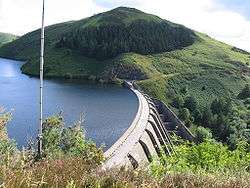
The town is close to the large dam and reservoir Llyn Clywedog. There is a scenic mountain road connecting Machynlleth and Llanidloes.
Llanidloes is popular with hikers who walk on the scenic footpaths surrounding the town, including Glyndŵr's Way, which in conjunction with the Offa's Dyke path forms a 160-mile circuit around Mid Wales and local passage over the spine of the Cambrian Mountains.
The Sarn Sabrina Walk – a 25-mile circular walk from Llanidloes to the source of the Severn and back – has been held yearly on the Saturday preceding the Late Spring Bank Holiday since 2006. In 2007 the Semi Sabrina, a 12-mile circular walk, was added.[2] The Hafren Forest is also used for car rallies such as Rally GB and motorcycle Enduro events throughout the year.
History
Llanidloes takes its name from the early seventh century Celtic Saint Idloes (Llan-Idloes = the Church of St Idloes), after whom its parish church is named. At this time it was part of the cantref of Arwystli. In 1280 Llanidloes received a market charter from the King (granted to Owen de la Pole) and the benefit of Edwardian town planning and earthwork defences. The present-day street plan follows the C13 grid layout. O’Neill[3] traced earth bank defences from the confluence of the Severn with the Clywedog and along Brook Street on the N, beyond High Street on the E, and along Mount Street on the s; with the Severn forming the w. boundary. He suggested that the Medieval castle with its bailey lay immediately to the south in the area of Mount Street. However, the precise positioning of the Castle and earthen bank defences need to be verified by archaeological evidence. The town prospered and was granted borough status at about this time, and by 1309 there were 66 Burgesses. Revival after the Glyndwr uprising was slow but there were 59 taxpayers in 1545.[4]
The following centuries saw the growth of weaving and flannel production. This was essentially a cottage industry and the local products were sent to market in Shrewsbury. Towards the end of the 18th century the Llanidloes was the largest producer in Montgomeryshire, but after about 1810, with the introduction of factories, which brought all the processes under one roof, Newton gradually overtook Llanidloes as the main centre. Some of the three storey houses with brick facades of this period would have housed weaving lofts on the upper storey[5] Lewis’s Topographical Dictionary of 1833 noted that there were forty carding engines, eighteen fulling mills and thirty-five thousand spindles .. affording considerable employment in Llanidloes. But the new technology was far from profitable and the factory system led to increasing unrest, which culminated in the Chartist riots in 1839. Newtown, connected to the Montgomeryshire Canal in 1819, was soon to become the centre of the flannel industry in Wales with the opening of its Flannel Exchange in 1832. Llanidloes followed suit in 1838 when former Public Rooms in Great Oak Street were built by a local consortium as a Flannel Exchange, but this was only to last a few years, although Llanidloes flannel was regarded as of the better quality. Some owners, particularly Thomas Jones, who owned the Cambrian and Spring Mills, struggled to promote the Llanidloes Flannel Industry, but by 1913, the last mill had closed. Leadmining became the more profitable industry from 1865, when rich deposits were discovered at the Van mines. By 1876, the mines were among the most productive in the world, employing over 500. Important too was the town’s iron foundry, established in 1851. This second phase of prosperity is well-reflected in the townscape, most notably in the proliferation of fine chapels, built during the 1870s. Commercial success is reflected by the many fine shopfronts that survive from the later part of the 19th century. But again decline set in, printing and tanning gained in importance, but the last of the mines closed in the 1921.[6] Little has changed since then, except the building of houses, including a Garden Suburb and a New School. The building of the by-pass of 1991, along the track of the former railway, has largely protected the town from the ravages of traffic. An attraction of Llanidloes are the tree lined main streets, originally planted in 1901, although many of the trees have been replaced. The vibrant community, pleasantly varied streetscape and attractive setting makes Llanidloes one of the nicest towns in Wales.[7]
The Chartist Uprising
Llanidloes was notorious as a focus of industrial unrest during the 19th century Chartist revolt in 1839, a campaign for democratic rights prompted by the collapse of the local textile industry. During the unrest, three local people were arrested and held in the Trewythen hotel on Great Oak Street until the protesters forced their release. The town was controlled by the protesters until a detachment of Shropshire Yeomanry arrived and restored Government authority. Ringleaders were arrested, tried and sentenced to imprisonment or transportation.
Church and Chapels
- The parish church St Idloes (Church in Wales). The 15th century tower has walls of large stones 7 ft thick, a battered at the base and a NE stair-turret. There is an Early Perpendicular west doorway. Timbered belfry with pyramidal roof, which has been dated to 1594 by Dendrochronology. Inside at belfry level a rib-vault with random slate infill; in its centre is the opening for raising bells. Street rebuilt the north aisle, resusing the early 16th century panel-traceried E window, and replaced the other windows with Perpendicular tracery. Attached to the north-west of the church is the Church Hall of 1982 by Phillip G. Harrison. The splendid solemn arcade in the aisle is part of the fourteen-bay aisled nave of the Cistercian church at Abbey Cwmhir some 10 m. SW across the hills. There is no doubt that the material was carted away after the Dissolution, and re-erected in slightly jumbled order at Llanidloes. The magnificent hammer-beam Roof is the most elaborate in Montgomeryshire. Hammerbeams on carved spandrel-pieces support curved ribs and principals, forming a sort of airy tunnel-vault. The framing is all delicately moulded. This type of roof often dates from the 15th century but there is no reason to doubt the date of 1542 (on the ninth shield from the NE) as dendrochronology has proved that the timbers were felled in 1538. The corbels are odd masonry bits including stiff-leaf from Cwmhir. The base of each bracket is carved, with an archer, or grotesque heads. Winged angels holding shields are fixed to each hammer beam.[8]
 Sion Chapel, Llanidloes
 - Trinity United Reformed Church, Shortbridge Street, formerly Sion Independent Chapel. Built in 1878 by John Humphreys of Swansea; a notable chapel builder. Set back within its plot to great effect. The three-bay façade has giant classical columns carrying arcading, with a pediment above. Rock-faced masonry with a smooth ashlar band over the trio of doorways containing plain lights for the lobby. Tall windows above with Florentine wooden tracery. The fine, varnished pine interior contains raked seating. The gallery, continuous round all four sides, has a band of cast iron foliagework over boarding, with a splendid organ above the pulpit. Pulpit with arcaded front. It cost £1,550 to build.[9]
Buildings in Llanidloes

- The half-timbered Old Market Hall stands at the crossroads of the four streets of the original medieval town. Built around 1600, it is the only surviving building of this type in Wales. Assize courts were held in the hall around 1605, and John Wesley preached from a pulpit stone on the open ground floor in 1748.
- Town Hall, Broad Street, Built by the architects Shayler and Ridge in 1908. Faced in Cefn stone from Minera. Frank Shayler was a notable Arts and Crafts architect and this is one of the best examples of his work.[10] The Town Hall now contains the Llanidloes Museum, Other local attractions include a museum containing a famous two-headed sheep, and many displays illustrating local life and industry.
- There are timber framed buildings and shop fronts in Llandiloes dating back to the Georgian Period.
Industry
- There was an iron-working company (finally closed in the early 1980s) that produced components for mining, railway and other machinery.
Bridges
- Two masonry arch bridges, the Long Bridge and the Short Bridge, were designed by Thomas Penson. The former is a 3-arch bridge built in 1826 over the confluence of the Rivers Severn and Clywedog and is currently Grade II listed. It replaced a mid 18th-century wooden bridge, also called Long Bridge.[11] Short Bridge is a single arch masonry bridge over the River Severn, dating from 1849.[12]
The Railway Station and the Newtown and Llanidloes Railway
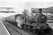
Llanidloes railway station was opened in 1864 by the Llanidloes and Newtown Railway.[13] Designed as a grand junction station, it was to connect the Mid-Wales Railway and the Manchester and Milford Railway in the south, with Newtown and the Oswestry and Newtown Railway to the north. Designed to hold the railway companies offices, the building is in the Georgian style. The Llanidloes and Newtown railway eventually formed part of the Cambrian Railways, linking it with South Wales. The station closed for passengers on 31 December 1962. The Llanidloes by-pass road runs along a section of the former railway, and the station still stands beside this road. It is now restored and occupied by small businesses.[14]
Llanidloes War Memorial Hospital
Powys Local Health Board (LHB) announced that it wanted to make cuts at Llanidloes which would result in the downgrading and even closure of Llanidloes War Memorial Hospital. The Save Llanidloes Hospital Action Group was formed in response.[15]
Culture and Environmentalism
Llanidloes has a reputation as a very "quirky" town, known for its liberal, counterculture atmosphere. Llanidloes is known as a popular home for ageing hippies.[16] The alternative atmosphere is immediately apparent upon visiting, thanks to the presence of a wholefood shop, a volunteer-run organic shop and a vegetarian wholefood café. In 2014, it was rated one of the most attractive postcode areas to live in Wales.[17]
In April 2006, Llanidloes was awarded Fairtrade Town status by the Fairtrade Foundation. Since October 2007 the annual Green Fair has attracted visitors to the town to listen to speakers on many 'green' issues and browse the stalls offering alternatives to energy expensive ways of life.
The town is noted for its annual Llanidloes Fancy Dress street party, one of the largest street parties in Wales.[18] The event started in 1969, taking place on the first Friday of July.[18][19] In 2004 around 5,000 people took part in the festival.[18] The 2005 event was temporarily cancelled due to the costs of safety provisions, but a local councillor provided funding for training for stewards and public toilets.[20][21] After concerns linked to costs and public safety the festival was cancelled in 2012.[22] It now takes place on a smaller scale with locals dressing up and taking to the streets.
The headquarters of The Quilt Association is at the Minerva Arts Centre; here they hold workshops and an annual exhibition of quilts.[23]
Sport
Llanidloes Town Football Club, established in 1875, play in the Cymru Alliance.[24]
Llanidloes rugby union team, Llanidloes RFC, play in the Welsh Rugby Union league.
Llanidloes Ladies F.C. play in both the Welsh National League and North Powys League
Used for the WEC GP of Wales
Education
Llanidloes High School is a secondary school. Llanidloes Primary school is a primary school.
Notable people
- See Category:People from Llanidloes
- Elinor Bennett (b. 1943), harpist
- Mickey Evans (b. 1947), footballer
- John Ceiriog Hughes (b. 1832), romantic poet and stationmaster
Town twinning
Literature
- Horsfall-Turner E.R. (1908) A Municipal History of Llanidloes.
References
- 1 2 "Area: Llanfyllin (Ward) Welsh Language Skills, 2011 (KS207WA)". Office for National Statistics.
- ↑ http://www.llanidloes.com/sarn_sabrina/index.html
- ↑ O’Neill B H St J (1933), The Castle and Borough of Llanidloes Montgomeryshire Collections, Vol xllll, 56ff.
- ↑ Soulsby I,(1983) The Towns of Medieval Wales, Chichester, 1983, 170–1.
- ↑ Jenkins J. G. The Welsh Woollen Industry, 148–151 for a discussion of relative importance prior to mechanisation in the later 18th century.
- ↑ http://history.powys.org.uk/history/llani/van1.html
- ↑ Scourfield, R; Haslam, R (2013). Buildings of Wales: Powys; Montgomeryshire, Radnorshire and Breconshire (2nd ed.). Yale University Press. pp. 165–166.
- ↑ Scourfield & Haslam (2013), pp. 166–168.
- ↑ Scourfield & Haslam (2013), pp. 168–169.
- ↑ Scourfield & Haslam (2013), p. 170.
- ↑ Long Bridge, Long Bridge Street, Llanidloes, British Listed Buildings. Retrieved 3 January 2016.
- ↑ Short Bridge, Short Bridge Street, Llanidloes, British Listed Buildings. Retrieved 3 January 2016.
- ↑ http://history.powys.org.uk/history/llani/railway1.html
- ↑ Scourfield & Haslam (2013), p. 173.
- ↑ bbc.co.uk/wales
- ↑ Andrews, Robert (2004). The Rough Guide to Britain. Rough Guides Ltd. p. 838. ISBN 978-1-84353-301-6.
- ↑ "UK's 'most desirable' postcodes revealed". BBC News.
- 1 2 3 "Town ready for fancy dress fiesta". BBC.co.uk. 1 July 2004.
- ↑ The Rough Guide to Wales Mike Parker, Paul Whitfield. p. 267
- ↑ Town's fancy dress fiesta is axed BBC Friday, 29 April 2005
- ↑ Fancy dress festival's reprieve BBC Wednesday, 22 June 2005
- ↑ "Fancy Dress Axed". www.cambrian-news.co.uk. 23 November 2011.
- ↑ "The Quilt Association". Retrieved 25 April 2015.
- ↑ bbc.co.uk/wales/mid/sites/sport
External links
| Wikimedia Commons has media related to Llanidloes. |
- Llanidloes.com – official town website
- Llanidloes Museum
- Llanidloes on the Powys Digital History Project
- www.geograph.co.uk : photos of Llanidloes and surrounding area