Llansantffraid-ym-Mechain
| Llansantffraid-ym-Mechain | |
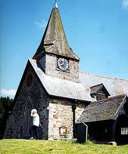 St Ffraid's Church, Llansantffraid-ym-Mechain |
|
 Llansantffraid-ym-Mechain |
|
| OS grid reference | SJ220203 |
|---|---|
| Community | Llansantffraid[1] |
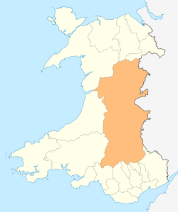
| Principal area | Powys |
| Ceremonial county | Powys |
| Country | Wales |
| Sovereign state | United Kingdom |
| Post town | LLANSANFFRAID[2] |
| Postcode district | SY22 |
| Dialling code | 01691 |
| Police | Dyfed-Powys |
| Fire | Mid and West Wales |
| Ambulance | Welsh |
| EU Parliament | Wales |
| UK Parliament | Montgomeryshire |
| Welsh Assembly | Montgomeryshire |
Coordinates: 52°46′30″N 3°09′25″W / 52.775°N 3.157°W
Llansantffraid-ym-Mechain is a village, community and post town in Powys, mid Wales, close to the border with Shropshire in England, about 7 miles (11 km) south west of Oswestry and 8 miles (13 km) north of Welshpool. It is on the A495 road and is at the confluence of the River Vyrnwy and the Afon Cain.
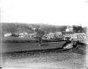 View of Llansantffraid across the river ca. 1885
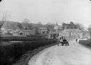 The main road through Llansantffraid ca. 1885
Llansanffraid means "Church of Saint Bride" in the Welsh language, and ym-Mechain refers to its location in the medieval cantref of Mechain and distinguishes it from other places with the same or similar names.
The name is based on the story of St Bhrid, who is said to have floated across the Irish Sea on a sod of turf, or to have been carried to Scotland by two oystercatchers. The followers of St Bhrid possibly set up new settlements known by the Welsh as Llan Santes Ffraid, Church of (Lady) Saint Bhrid.
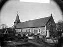 Church of St Ffraid ca. 1885
_NLW3361761.jpg) Interior of Church of St Ffraid ca. 1885
Interior of Church of St Ffraid ca. 1885
In recent years the spelling of the village name, with or without a "t", has been a contentious issue (similar to that of the nearby Llansantffraid Glyn Ceiriog) and this has been recognised by Powys County Council providing a dual spelling of the village name on road signs in the locality.
History
Early settlers
Many finds of Beaker pottery, dating from 2400 to 2000 BC, suggest settlement of the area in the Bronze Age. Earlier, Neolithic settlement is likely, though there are currently no such sites known in the immediate area. During the Iron Age, around 700 BC, a trend towards a sedentary lifestyle is evidenced by the increased number of settlements. A small hilltop enclosure was built around 400 BC where inhabitants grew wheat and barley, and kept cattle, sheep and pigs. Aerial photography of the area shows evidence that a pit alignment, possibly Iron Age, is present in the grounds of the nearby Bryn Tanat Hall Hotel.
The Romans
Roman archeological evidence in the area includes a Roman fort in Bronhyddon field adjacent to Cae Hywel orchard. An archaeological excavation at this site revealed a barracks with attached centurion's house.
The historic Plas-Yn-Dinas
The Plas-Yn-Dinas, 5 km west of Offa's Dyke and above the flood plain of the Afon Fyrnwy, is a scheduled ancient monument,[3][4] it was probably a timber castle but certainly a fortified manor house. It is first recorded in the 14th century as the residence of the lords of Mechain Is Coed.[5] Some of the earthworks could be from the Roman period and it is reputed to be the site of the Roman station of Mediolanum.[6]
See also: Images of Plas-Yn-Dinas
Y Foel Camp
Y Foel Camp is situated on the summit of the Foel Hill, to the west of the Winllan Road. It has many hallmarks of an Iron Age fortification and there are signs of a rampart and a ditch.
Skirmishes and battles
Two battles fought within this parish are recorded. Around the middle of the 5th century a battle is said to have taken place in the township of Llanerch. Emrys wen Pascen, a traitor, induced the Saxons to attack the Welsh. Emerys Benaur was appointed head of the Welsh army, and his victory secured the naming of the township in his honour. These events have no known factual basis.
The second recorded battle was fought between Meredydd and Ithel, sons of Gruffydd ap Llywelyn, on one side and Bleddyn and Rhiwallon on the other. The battle was fought for the crown of Gwynedd and Powys. Ithel and Rhiwallon were slain and Meredydd took flight, leaving Bleddyn the sole king of North Wales and Powys.
Evolution of the village name
The earliest written form in Liber Landavensis, The Book of Llandav, a 12th-century document, refers to 'Llann sanfreit' in 1066. With so many places named Llansanffraid in Wales it was necessary to add location details, hence Llansanffraid-ym-Mechain (in Mechain) and Llansanffraid Glyn Ceiriog etc. The earliest written record of Llansanffraid-ym-Mechain is 1254 as 'Llansanfret'.
In 1526 the name of the village appeared as 'Llansayntefrayde' in an English document. "The 'saynte' suggests an English influence on the Welsh name."[7] The English language Tithe Maps of the early 1800s use two anglicised forms, 'Llansaintffraid' and 'Llansaintfraid'.
The first Ordnance Survey Drawing map by Robert Dawson in 1830 records the spelling of the village name as 'Llansanffraid'.[8]
Welsh place names were often anglicised. For example, when the railway arrived in the village in 1862, the station was called 'Llansaintffraid'. The Border Advertiser was originally a railway company publication to advertise the railway but as it became a local newspaper it continued to use this spelling.
By the beginning of the 20th century the 'i' was lost and the spelling appears to change again. In 1922 when the GWR took over the Cambrian Railways, the station name changed to Llansantffraid.[9]
Apparently, in 2008, the letter 't' was officially dropped by Powys County Council, which claimed it was correcting a "mistake".[10] Nonetheless, the council's website still referred to the village as "Llansantffraid".[11] The different spellings in the name of the village were also reflected on local road signs.
However, on 30 September 2014, Powys County Council voted to restore the "missing" 't'.[12]
Football team
The local football team, previously known as Total Network Solutions F.C., won the League of Wales in the 2004-05 season, the first title since changing its name from Llansantffraid FC. Following the takeover of its sponsors, the team was renamed The New Saints F.C. for the 2006-07 season. The New Saints no longer play their football matches in Llansantffraid-ym-Mechain, but in Park Hall, a village in Shropshire, 2 miles (3.2 km) east of Oswestry.
See also
References
- ↑ Ordnance Survey. "Election Maps". Retrieved 20 October 2012.
- ↑ Royal Mail Address Management Unit (March 2011). "Postcode Update 52" (PDF). Retrieved 20 October 2012.
- ↑ "PLAS-YN-DINAS". Coflein.
- ↑ "Plas yn Dinas Castle". CPAT.
- ↑ "Plas yn Dinas, Llansantffraid". Gatehouse Gazetteer.
- ↑ "Llansantffraid Montgomeryshire". Vision of Britain.
- ↑ Dr E. James. Terminology, Standardisation and Translation Unit, Welsh Language Board, (2010)
- ↑ Oswestry Ordnance Survey Drawing (1830) OSD 330.
- ↑ Neil Rhodes. Trains on the Border. Neil Rhodes Books (2012)
- ↑ "Llansanffraid survey suggests villagers want 'T' back". BBC News. 2010-11-22.
- ↑ Powys County Council. "About Llansantffraid Electoral Division". Powys County Council. Retrieved 8 May 2013.
- ↑ "Llansanffraid is now Llansantffraid". The Independent. Retrieved 13 October 2014.
External links
- Photos of Llansantffraid-ym-Mechain and surrounding area on geograph
- Historic Photos of Llansantffraid-ym-Mechain