List of round barns
What are termed round barns include historic barns having true circular designs and also octagonal or other polygonal designs that approximate a circle. In the United States, in a first era of round barn construction, from 1850 to 1900, numerous octagonal barns were built. In a second era, from 1889 to 1936, numerous true circular barns were built.[1][2]
This list article includes surviving or historic round barns in Canada, the United States, and elsewhere. There were 19 historic round and polygonal barns in Canada identified as surviving in the 1970s, in a list compiled by Katherine Kirkam.[3] According to Matthew Farfan, nine round barns survive in the Eastern Townships of the province of Quebec, all close to the U.S. border.[4][note 1]
Besides paying attention to Canadian barns, Kirkham also studied American barns; in the 1970s, she identified 444 surviving barns in the United States.[3] Many of them are listed on the National Register of Historic Places.[5]
Dale J. Travis has identified and photographed (or collected photos of round barns and other round or polygonal buildings throughout the United States and Canada.[6] His webpages document the loss of numerous historic round barns.
The periods during which round barns were built varies across U.S. states. Most of Indiana's round barns were built between 1900 and 1920, and their construction peaked in 1910. Iowa's peak years were from 1909 to 1922. All 44 of the historic round barns built in South Dakota were built between 1903 and 1946. North Dakota's peak years were from 1910 to 1916. South Dakota had none built before 1900 because the state had yet to be developed.[7]
Canada
As documented here, there are at least 11 surviving octagonal, true round, and other round-type barns in Quebec. A few others survive in British Columbia, Alberta and Ontario. A list of round or near-round structures in Quebec, including historic round barns, developed by Dale J. Travis has informed this compilation.[8] Following is intended to be a complete list, from West to East:
| Building | Image | Dates | Location | City, Province | Description |
|---|---|---|---|---|---|
| Fintry Estate barn | 1925[9] | Fintry Provincial Park and Protected Area, 7655 Fintry Delta Rd.50°08′14″N 119°30′13″W / 50.1371°N 119.5036°W | Fintry, Okanagan Country, British Columbia | Restored dairy barn at Fintry Provincial Park and Protected Area Fintry Barn or Dun-Waters Barn?[10] | |
| Henderson Round Barn |  |
Built 1898, moved 1972 | Fort Edmonton Park 53°30′01″N 113°34′51″W / 53.5004°N 113.5809°W |
Edmonton, Alberta | Preserved in a historical park.[4][11] |
| Sowerby Barn | 1928[12] | 131 Brownlee Rd (at Round Barn Rd)46°16′57″N 83°25′58″W / 46.28248°N 83.43273°W | Huron Shores, Ontario | One of three 12-sided barns still existing in Canada[12][13] | |
| Cordukes/Weber Barn | 1919[12] | 1410 Basswood Lakes Road46°17′54″N 83°23′20″W / 46.29841°N 83.38881°W | Algoma, Ontario | 12-sided barn, site of farmers market, has been dismantled, moved and rebuilt adjacent to Sowerby Hall (formerly the Day and Bright Community and Recreation Centre) at 1410 Basswood Lake Road, near Hendry Street.[12][13][14][15][16] (Barn is clearly visible from right in front of Sowerby Hall in Google maps' street view, and is clearly visible in Bing's satellite view). | |
| Octagon barn south of Osgoode | 5672 Dalmeny Road45°07′05″N 75°35′06″W / 45.11813°N 75.58509°W | Osgoode, Ontario | [17] | ||
| Higginson Round Barn | 1893-94 | 2500 Highway 34 45°34′48″N 74°37′21″W / 45.58000°N 74.62250°W |
Hawkesbury, Ontario | ||
| Walbridge Barn |  |
1882 | Chemin de Mystic 45°09′09″N 72°59′18″W / 45.15262°N 72.98823°W |
Mystic, Quebec | Oldest surviving polygonal barn in Canada, and only 12-sided one.[18] Also known as Grange Alexander-Solomon-Walbridge, it has a unique roof, became Quebec historic site in 2004 and became a museum in 2011[4][19][20] |
| Round barn at West Brome | Chemin Scott45°10′22″N 72°40′27″W / 45.17290°N 72.67410°W | West Brome, Quebec | [4][21] | ||
| Grange Ronde de Mansonville | .JPG) |
Rue Joseph Blanchet 45°03′11″N 72°23′37″W / 45.0531°N 72.3937°W |
Mansonville, Quebec | True round barn[4][8] | |
| Round barn at Saint-Benoit-du-Lac | Chemin Fisher 45°09′30″N 72°16′13″W / 45.15834°N 72.27020°W |
Saint-Benoit-du-Lac, Quebec | A round barn and a round hay tower[4] | ||
| Grange ronde Stanley-Holmes |  |
1907 | Chemin Holmes 45°07′14″N 71°58′28″W / 45.120551°N 71.974350°W |
Barnston-Ouest | Rbcq: "W. of Barnston. Hwy.141 W. from Barnston to Chemin Caron Rd., S. on Chemin Caron Rd. & SE on Chemin de Way's Mill & the barn would be on the right hand (S.) side of the road. Holmhurst Farm, true round barn, red horizontal siding, 2 pitch conical roof, louvered cupola."[8] This is Stanley-Holmes Round Barn, on Holmhurst Farm. (Is this also known as Holmes' Barn? Or is this 2nd of two round barns near Ways Mills?) |
| Round barn south of Barnston | 1909[8] | Chemin de Baldwin Mills Barnston 45°06′03″N 71°53′19″W / 45.1008°N 71.8885°W |
South of Barnston, Coaticook, Quebec | True round barn with two-pitch conical roof with a cupola, at Ferme Blayrond[4][8] | |
| Round barn at Barnston | 1901[8] | Chemin Riendeau 45°06′24″N 71°52′42″W / 45.106620°N 71.878271°W |
Barnston, Coaticook, Quebec | In Barnston. True round barn with two-pitch conical roof, with cupola[8] | |
| Grange Ronde | built 1995 | 400 Rue St. Marc., Gorge de Coaticook Park45°08′41″N 71°47′51″W / 45.14477°N 71.79761°W | Coaticook, Quebec | [4] | |
| Round barn west of Beaumont | Pre-1850[8] | Route du Fleuve (Route 132) 46°49′45″N 71°02′25″W / 46.829175°N 71.040144°W |
Beaumont, Quebec | White barn[8] | |
| Adolph Gagnon Museum | 1888[8] | 48°17′51″N 68°51′57″W / 48.297637°N 68.865842°W | Saint-Fabien, Quebec | Museum now in former barn[8] | |
| Octagonal barn west of Cap Chatte | Rue Notre Dame Ouest (2.5 miles west of Cap-Chat)49°05′12″N 66°43′55″W / 49.08668°N 66.73190°W | Cap-Chat, Quebec | Octagonal barn west of Cap Chatte[4] | ||
| Round barn near Dunham | Dunham, Quebec | Near Dunham[4] | |||
| Holmes' Barn | c. 1907[22] | Ways Mills, Quebec | [4][23] Is this the round barn west of Barnston (Travis's QC-11-05)? [24] | ||
| Second of two round barns near Ways Mills | Ways Mills, Quebec | [4] | |||
United States
West: California, Oregon, Washington, New Mexico, Colorado
| Building | Image | Dates | Location | City, State | Description |
|---|---|---|---|---|---|
| Barn north of American Canyon | S. Napa Junction Rd 38°10′43″N 122°14′53″W / 38.17868°N 122.24803°W |
American Canyon, Napa Valley, California | 20-sided, 100 feet (30 m) barn[25] | ||
| Octagon barn south of San Luis Obispo |  |
built pre-1900, restored 2009[26] | Octagon Way, off Higuera St. 35°14′13″N 120°40′47″W / 35.23687°N 120.67959°W |
San Luis Obispo, California | Octagonal barn, 77 feet (23 m) by 80 feet (24 m)[26] |
| Knight Barn | built 1894-96 | 2955(?) Copenhagen Road 40°40′40″N 124°15′12″W / 40.677882°N 124.25336°W |
Loleta, California | 16-sided barn, shown standing in photos by Mary Louise Lorensen.[27] Shows collapsed in center in Google 2016 satellite imagery. | |
| Fountaingrove Round Barn |  |
Fountaingrove Parkway at Round Barn Blvd 38°28′33″N 122°43′39″W / 38.475767°N 122.72746°W |
Fountaingrove, Santa Rosa, California | 16-sided[28] | |
| De Turk Round Barn |  |
built 1891 NRHP 2004 |
819 Donahue St. 38°26′28″N 122°43′26″W / 38.44111°N 122.72389°W |
Santa Rosa, California | [29] |
| R. L. Johnston Round Barn (also called Beaver Creek Ranch Barn[30]) |  |
18-sided barn built in 1916; last remains dismantled 2007; rebuilt 2009 | Fort Crook Ave 41°00′07″N 121°26′47″W / 41.001843°N 121.446295°W |
Fall River Mills, California | Built "...to break and train wild horses for the U. S. Army." Reconstructed on grounds of Fort Crook Museum.[31][30][32] |
| Pete French Round Barn | _(harDA0027).jpg) |
Built c. 1875-1885 | 43°07′57″N 118°38′33″W / 43.13250°N 118.64250°W | Burns, Oregon | Cattle rancher Peter French (1849-1897) broke and trained horses there in winter. |
| Laughlin Round Barn | built 1883 NRHP 1986 |
46°20′25″N 122°55′24″W / 46.34028°N 122.92333°W | Castle Rock, Washington | ||
| Ojo Caliente Hot Springs Round Barn | Ojo Caliente, New Mexico | ||||
| DeLaney Barn |  |
built 1902; NRHP 1989 | 200 S. Chambers Rd. 39°42′48″N 104°48′27″W / 39.71333°N 104.80750°W |
Aurora, Colorado | Only surviving round barn in Colorado. Built in 1902 as a silo. Converted into a dairy barn by 1910.[33] |
Midwest
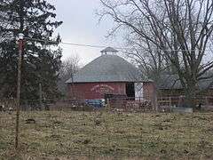
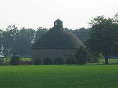
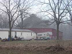
Illinois
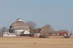
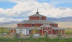
_01.JPG)


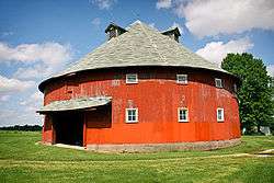
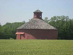
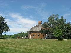
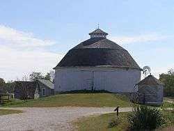
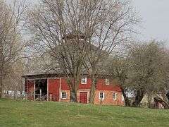
Indiana

Ohio
| Building | Image | Dates | Location | City, State | Description |
|---|---|---|---|---|---|
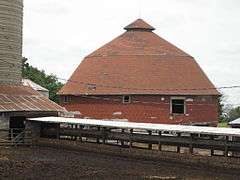
| Round Barn (Columbus Grove, Ohio) | Built 1910 NRHP 1980 |
Columbus Grove, Ohio | |||
| Round Barn (Lima, Ohio) | 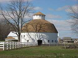 |
Built 1911 NRHP 1980 |
Lima, Ohio | ||
| Round Barn (New Hampshire, Ohio) | 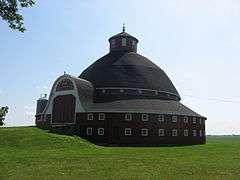 |
Built 1877 NRHP 1980 |
New Hampshire, Ohio | Also known as J.H. Manchester Round Barn | |
| Round Barn (Paulding, Ohio) | 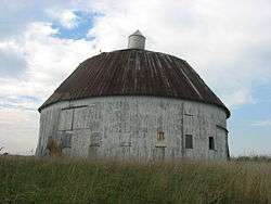 |
Built 1911 NRHP 1980 |
Paulding, Ohio | ||
| Round Barn (Van Wert, Ohio) |  |
Built 1910 NRHP 1980 |
Van Wert, Ohio | Also known as Clayton Hoover Round Barn | |
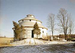
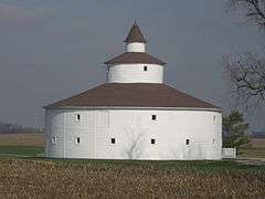
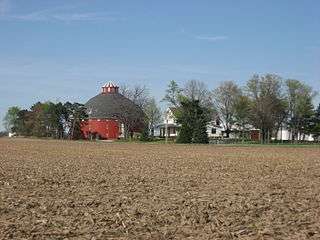
Iowa

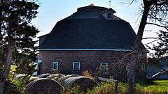


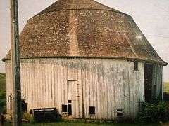

Also the Seymour Ross Round Barn was NRHP-listed, but was demolished.
Wisconsin
| Building | Image | Dates | Location | City, State | Description |
|---|---|---|---|---|---|
| Dougan Round Barn | 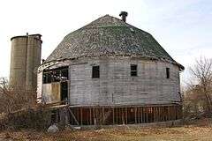 |
built 1911 NRHP 1979 |
42°30′29″N 88°59′20″W / 42.50806°N 88.98889°W | Beloit, Wisconsin | Served a dairy farm of 120 cows.[36] The barn was demolished in 2012.[37] |
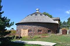
| George Apfel Round Barn | built 1914 NRHP 1979 |
43°39′15″N 90°41′24″W / 43.65417°N 90.69000°W | Clinton, Wisconsin | Octagonal in shape. | |
| Annala Round Barn | built 1921 NRHP 1979 |
46°25′5″N 90°9′41″W / 46.41806°N 90.16139°W | Hurley, Wisconsin | ||
| Central Wisconsin State Fair Round Barn |  |
built 1916[38] NRHP 1979 |
Jct. of Vine Ave. and E. 17th St. |
Marshfield, Wisconsin | The world's largest round barn! |
| Dean-Armstrong-Englund Octagonal Barn | built 1893 NRHP-delisted 1984 |
Near Milton, Wisconsin | It had a windmill.[36]:3 | ||
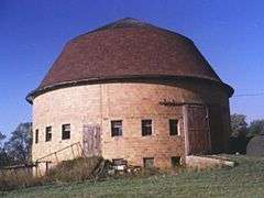
| Gempeler Round Barn | built 1912 NRHP 1979 |
42°39′50″N 89°19′50″W / 42.66389°N 89.33056°W | Near Orfordville, Wisconsin | 68 foot diameter barn, "significant for its ingenious construction, with its main story supported by an inverse pylon made up of an oak trunk upside down in the center of the basement"[36]:10 | |
| Risum Round Barn | built 1892 NRHP 1979 |
42°35′55″N 89°17′35″W / 42.59861°N 89.29306°W | Orfordville, Wisconsin | Built early, in 1890-92, for a Norwegian immigrant; a 60-foot diameter barn.[36]:6–7 | |
North Dakota

South Dakota
| Building | Image | Dates | Location | City, State | Description |
|---|---|---|---|---|---|
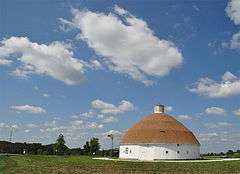
| Freier Round Barn | Draper, South Dakota | ||||
| Shafer Round Barn | 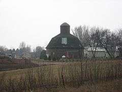 |
built 1920 NRHP 1995 |
43°32′31″N 96°38′58″W / 43.54194°N 96.64944°W | Sioux Falls, South Dakota | |
| Stark Round Barn | built 1921 NRHP 2001 |
43°48′14″N 97°27′4″W / 43.80389°N 97.45111°W | Near Unityville, South Dakota | ||
| Corson Emminger Round Barn | Watertown, South Dakota | ||||
| J. Whitney Goff Round Barn |  |
Winfred, South Dakota | |||
Kansas, Minnesota, Nebraska, Oklahoma


.jpg)
Mid-Atlantic
Delaware, Pennsylvania
| Building | Image | Dates | Location | City, State | Description |
|---|---|---|---|---|---|
| Cherbourg Round Barn | 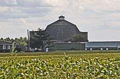 |
built 1918 NRHP 1978 |
39°9′4″N 75°27′27″W / 39.15111°N 75.45750°W |
Little Creek, Delaware | |
| Neff Round Barn |  |
built c.1910 NRHP 1979 |
Off of Pennsylvania Route 45, Potter Township 40°49′3″N 77°42′6″W / 40.81750°N 77.70167°W |
south of Centre Hall, Pennsylvania | |
| Noah Sheely Round Barn | built 1914 NHRP 1994 |
Gettysburg, Pennsylvania | Currently used as a fruit market by the Knouse Family (Knouse Fruitlands, Inc.). Visitors can tour the barn, view its structure and reserve the barn for weddings and special events. | ||
New York


NY notes
Gamel hexadecagon barn[45] 16-sided Gamel barn in North Collins, New York
Schultz 15-sided barn (1918-1929)[45] at Cohecton not listed due to DOE owner objection
"Nine octagonal barns, most built in the 1870s and 1880s, have been noted in New York, and undoubtedly many more have never been recorded. Extant examples in the nominated group include the Baker octagon barn near Richfield Springs (1882) , the Lunn-Musser octagon barn in New Lisbon (1885) , and the Lattin-Crandall octagon barn in Catharine (1893)."[45]
McArthur-Martin barn in Kortright (1883) 16-sided[45]
Parker 13-sided barn (1896) about 15 miles north of Kortright in Jefterson[45]
"Roof types among the nominated examples include conical (for example the Schultz 15-sided barn at Cochecton, New York (1918), gambrel. (the Young round barn at Greene-1914), and domical (Bates barn at Greene)."[45]
11 of 12 listed, p21[45]
New England
Massachusetts, New Hampshire
| Building | Image | Dates | Location | City, State | hidden----> |
|---|---|---|---|---|---|
| Round barn at Hancock Shaker Village |  |
Hancock, Massachusetts | |||
| Round barn on NH-10 | 430 NH-1044°00′36″N 72°04′10″W / 44.01000°N 72.06938°W | Piermont, New Hampshire | There is "Round Barn Shoppe" identified on Google maps. | ||
Vermont
| Building | Image | Dates | Location | City, State | Description |
|---|---|---|---|---|---|
| Ralph Joslin barn[54] | 1910 | E. Warren Rd44°10′05″N 72°48′41″W / 44.16805°N 72.81127°W | Waitsfield, Vermont | 12-sided barn built 1910, restored 1990, at Green Mountain Cultural Center[54] Farm had been in one family seven generations.[55] An "Inn at the Round Barn Farm" is there. | |
| Robinson Brothers barn | 1910,16(?) | Robinson Road43°50′13″N 72°26′02″W / 43.837057°N 72.434026°W | Strafford Township, Orange County, Vermont | 10-sided barn[56] | |
| Russell Moore barn | 1899 | U.S. 544°20′34″N 72°02′35″W / 44.342831°N 72.042986°W | St. Johnsbury, Vermont | Russell Moore barn,[57] moved 1985-86 partly by helicopter and serves as orientation center of the Shelburne Museum.[58] | |
| Butson barn | 1903 | Round Barn Road44°07′42″N 72°02′35″W / 44.12845°N 72.04301°W | Wells River, Vermont | [59] | |
| Field barn | 1912 | Satterly Rd44°11′32″N 73°14′31″W / 44.19216°N 73.24187°W | Ferrisburgh, Vermont | [60] | |
| Welch barn | 1916 | Elmore Rd.44°33′14″N 72°33′01″W / 44.553764°N 72.550159°W | Morristown, Vermont | 20-sided barn, 75'x40'[61] | |
| Southwick or Haberman barn | 1911 | Calais, Vermont | [62] | ||
| Round Barn Apartments | 1902 | Faywood Rd.44°44′36″N 73°16′39″W / 44.743458°N 73.277593°W | Grand Isle, Vermont | Round barn converted into apartments.[63] | |
| 12-sided barn | 2604 E. Hill Rd.43°18′47″N 72°42′02″W / 43.313042°N 72.700543°W | Andover, Vermont | 12-sided barn[64] | ||
South: MO, GA, VA, WV
| Building | Image | Dates | Location | City, State | Description | |
|---|---|---|---|---|---|---|
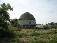
| Orrie J. Smith Round Barn | 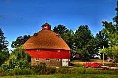 |
40°13′32″N 92°33′33″W / 40.22556°N 92.55917°W} |
Kirksville, Missouri | In Orie J. Smith Black and White Stock Farm Historic District, NRHP-listed | ||
| Rea Octagonal Barn | 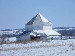 |
Rea, Missouri | ||||
| Dorough Round Barn and Farm | built 1917 NRHP Jan. 20, 1980 now in complete disrepair |
Hickory Level, Georgia | ||||
| Round barn in New Market | 13789 N. Valley Pike38°36′05″N 78°42′57″W / 38.60131°N 78.71582°W | New Market, Virginia | Identified as "The Round Barn" already in Google maps. | |||
| Washington's 16-Sided Barn | built 1793 | Mount Vernon, Virginia | ||||
| Hoffman Round Barn | Wolftown, Virginia | |||||
| Hamilton Round Barn | Mannington, West Virginia | |||||
Europe
| Building | Image | Dates | Location | City, State | Description |
|---|---|---|---|---|---|
| Bakendorf round barn |  |
Bakendorf, Mecklenburg-Western Pomerania, Germany | Now a converted barn | ||
| Fincken Round Barn |  |
53°21′20″N 12°26′33″E / 53.35556°N 12.44250°E | Fincken, district Müritz, Mecklenburg-Western Pomerania, Germany | Used as a fire station | |
| Bjärtrå Folk Museum Round Barn |  |
circa 1858 | 62°59′19″N 17°52′33″E / 62.98861°N 17.87583°E | Bjärtrå, near Kramfors, Sweden | |
| Round Barn in Viätt |  |
63°04′18″N 17°49′43″E / 63.07167°N 17.82861°E | Viätt, Kramfors, Sweden | Hexagonal, log barn or granary | |
| Nätra Folk Museum Round Barn | .JPG) |
63°12′06″N 18°31′10″E / 63.20167°N 18.51944°E | Örnsköldsvik, Sweden | Technically an octagonal, log granary | |
Notes
- ↑ This list confirms existence of 15 round or polygonal barns in Canada (8 of them in Quebec near the U.S. border) from Google and Bing satellite view, as of the satellite photos presented in Google and Bing in March 2016.
References
- ↑ Auer, Michael J. The Preservation of Historic Barns, Preservation Briefs, National Park Service, first published October 1989. Retrieved 7 February 2007.
- ↑ Round and Polygonal Barns of Indiana, (PDF), National Register of Historic Places Multiple Property Documentation Form, NRIS Database, National Register of Historic Places. Retrieved 8 February 2007.
- 1 2 "Round Barn Capital of the World?". Fulton County Historical Society.
- 1 2 3 4 5 6 7 8 9 10 11 12 Matthew Farfan. "Round Barns". TownshipsHeritage WebMagazine.
- ↑ National Park Service (2010-07-09). "National Register Information System". National Register of Historic Places. National Park Service.
- ↑ http://www.dalejtravis.com/
- ↑ Jerry McMahan (October 18, 1991). "National Register of Historic Places Multiple Property Documentation: Round and Polygonal Barns of Indiana" (PDF). National Park Service.
- 1 2 3 4 5 6 7 8 9 10 11 Dale J. Travis. "Quebec Round Barns List".>ref group=note>One barn in Quebec on Chemin Tetreault noted by Travis as possibly gone, is not now found on Google maps satellite view.
- ↑ at Dale Travis
- ↑ http://www.dalejtravis.com/barn/canada/htm/bc00001.htm
- ↑ Henderson Round Barn at Dale Travis
- 1 2 3 4 "Historic 12-Sided Barn". Municipality of Huron Shores.
- 1 2 Pat Kerr (June 3, 2012). "Get around, get around, I get around".
- ↑ "Sowerby Farmers Market".
- ↑ Interior pic of wedding
- ↑ 2015 Algoma Travel Guide, p. 60
- ↑ this barn, Dale J. Travis
- ↑ Per historic plaque,
- ↑ Matthew Farfan (May 10, 2010). "Missisquoi Museum and Walbridge Barn Set to Open". Townships Heritage.
- ↑ Matthew Farfan (March 9, 2011). "Walbridge Barn Now a Museum".
- ↑ location
- ↑
- ↑
- ↑ QC-11-05
- ↑ "Barn north of American Canyon". Dale J. Travis.
- 1 2 "Barn south of San Luis Obispo". Dale J. Travis. Retrieved 16 June 2016.
- ↑ "Knight Barn". Dale J. Travis.
- ↑ "Fountain Grove Round Barn". Dale J. Travis.
- ↑ "DeTurk Round Barn". Dale J. Travis.
- 1 2 "Beaver Creek Ranch Barn (new)". Dale J. Travis. Retrieved 16 June 2016.
- ↑ http://shastacountyhistory.com/reconstructing_the_round_barn
- ↑ "Beaver Creek Ranch Barn (old)". Dale J. Travis. Retrieved 16 June 2016.
- ↑ Ramona G. Hutchinson and Lewis A. Hutchinson (January 1988). "National Register of Historic Places Registration: DeLaney Barn / The Silo / The Milk Barn / Bresnahan Ranch" (PDF). National Park Service. Retrieved 2016-06-17. with seven photos from 1988
- 1 2 "Iowa Round Barn List". Dale Travis Barn List. Retrieved 2011-01-05.
- ↑ "IA00305". Dale Travis Barn List. Retrieved 2011-01-05.
- 1 2 3 4 Nancy Belle Douglas (November 10, 1978). "National Register of Historic Places Multiple Property Documentation: Centric Barns in Rock County TR" (PDF). National Park Service.
- ↑ "Historic Dougan Round Barn demolished". Beloit Daily News. 19 April 2012. Retrieved 13 July 2012.
- ↑ "Central Wisconsin State Fair". Central Wisconsin State Fair. 2012-04-02. Retrieved 2012-07-07.
- ↑ L. Martin Perry (July 29, 1986). "National Register of Historic Places Inventory/Nomination: Urbain Cote Round Barn" (PDF). National Park Service. (pages 27-28 in North Dakota Round Barns TR) and accompanying photo from 1986
- ↑ L. Martin Perry (July 29, 1986). "National Register of Historic Places Inventory/Nomination: Cecil Baker Round Barn" (PDF). National Park Service. (pages 25-26 in North Dakota Round Barns TR) and accompanying photo from 1985
- ↑ L. Martin Perry (July 29, 1986). "National Register of Historic Places Inventory/Nomination: Jens Myhre Round Barn" (PDF). National Park Service. (pages 40-41 in North Dakota Round Barns TR) and accompanying photos
- ↑ L. Martin Perry (July 29, 1986). "National Register of Historic Places Inventory/Nomination: Niels Nielsen Fourteen-Side Barn Farm" (PDF). National Park Service. (pages 45-46 in North Dakota Round Barns TR) and accompanying photo from 1986
- ↑ "Snowstorm damages historic round barn". Lincoln Journal-Star. 2012-02-05. Retrieved 2012-04-30.
- ↑ "Round barn unlikely to be rebuilt". Omaha World-Herald. 2012-02-07. Retrieved 2012-05-04.
- 1 2 3 4 5 6 7 8 9 10 11 12 13 dairy barns mps
- ↑ "Bates Round Barn". Dale Travis Round Barn List. Retrieved 2016-04-10.
- ↑ "Young Round Barn". Dale Travis Round Barn List. Retrieved 2016-04-10.
- ↑ "13-sided barn at Bronck Museum". Dale Travis Round Barn List. Retrieved 2016-04-10.
- ↑ "Musser barn". Dale Travis Round Barn List. Retrieved 2016-04-10.
- ↑ "Donald Martin Barn". Dale Travis Round Barn List. Retrieved 2016-04-10.
- ↑ "Unnamed barn on Daniels Road". Dale Travis Round Barn List. Retrieved 2016-04-10.
- ↑ "Unnamed barn". Dale Travis Round Barn List. Retrieved 2016-04-10.
- ↑ "Unnamed barn". Dale Travis Round Barn List. Retrieved 2016-04-10.
- 1 2 "Ralph Joslin barn". Dale Travis Barn List. Retrieved 2016-04-09.
- ↑ long source
- ↑ "Robinson Bros". Dale Travis Round Barn List. Retrieved 2016-04-09.
- ↑ "Russell Moore barn". Dale Travis Barn List. Retrieved 2016-04-09.
- ↑ "Calendar: Barn city". Boston Globe. October 14, 1999.
- ↑ "Butson". Dale Travis Barn List. Retrieved 2016-04-09.
- ↑ "Field barn". Dale Travis Barn List. Retrieved 2016-04-09.
- ↑ "Welch barn". Dale Travis Round Barns. Retrieved 2016-04-09.
- ↑ "Southwick or Haberman barn". Dale Travis Barn List. Retrieved 2016-04-09.
- ↑ "Round Barn Apartments". Dale Travis Round Barns List. Retrieved 2016-04-09.
- ↑ "12-sided barn". Dale Travis Barn List. Retrieved 2016-04-09.