Traer, Iowa
| Traer, Iowa | |
|---|---|
| City | |
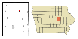 Location of Traer, Iowa | |
| Coordinates: 42°11′29″N 92°27′52″W / 42.19139°N 92.46444°WCoordinates: 42°11′29″N 92°27′52″W / 42.19139°N 92.46444°W | |
| Country |
|
| State |
|
| County | Tama |
| Government | |
| • Mayor | Pete Holden |
| Area[1] | |
| • Total | 1.18 sq mi (3.06 km2) |
| • Land | 1.18 sq mi (3.06 km2) |
| • Water | 0 sq mi (0 km2) |
| Elevation | 915 ft (279 m) |
| Population (2010)[2] | |
| • Total | 1,703 |
| • Estimate (2012[3]) | 1,679 |
| • Density | 1,443.2/sq mi (557.2/km2) |
| Time zone | Central (CST) (UTC-6) |
| • Summer (DST) | CDT (UTC-5) |
| ZIP code | 50675 |
| Area code(s) | 319 |
| FIPS code | 19-78735 |
| GNIS feature ID | 0462294 |
Traer is a city in Tama County, Iowa, United States. The population was 1,703 at the 2010 census.
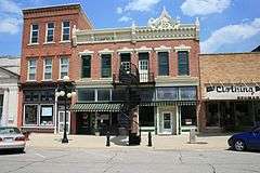
Traer is known for the iron winding staircase that originally led to the office of the local newspaper. The staircase is freestanding, reverse-spiral and connected to the building with a suspended walkway, a somewhat rare arrangement.
History
Traer had its start in the year 1873 by the building of Burlington, Cedar Rapids and Northern Railway through that territory.[4] The city was named for John W. Traer.[5]
Municipal services
Services provided by the city include a fire department, an ambulance service, a swimming pool, a public library, an airport, and two parks. The city is served by the North Tama School District.
Government
The city is governed by a mayor-council government, with a five-member council. It employs an attorney, a treasurer, a clerk and deputy clerk, and a gas and building inspector. The city runs multiple committees, on finance, streets, airport and garbage, recreation, public services, and protection. City boards include those responsible for the library, the airport, the parks, the memorial building, planning and zoning, the Wilson Nature Preserve, and historic preservation.
Geography
Traer is located at 42°11′29″N 92°27′52″W / 42.19139°N 92.46444°W (42.191495, -92.464374),[6] in Perry Township.
According to the United States Census Bureau, the city has a total area of 1.18 square miles (3.06 km2), all of it land.[1]
Important roads in Traer include U.S. Route 63 and Iowa Highway 8.
Demographics
| Historical populations | ||
|---|---|---|
| Year | Pop. | ±% |
| 1880 | 1,100 | — |
| 1890 | 1,014 | −7.8% |
| 1900 | 1,458 | +43.8% |
| 1910 | 1,283 | −12.0% |
| 1920 | 1,329 | +3.6% |
| 1930 | 1,417 | +6.6% |
| 1940 | 1,493 | +5.4% |
| 1950 | 1,627 | +9.0% |
| 1960 | 1,623 | −0.2% |
| 1970 | 1,682 | +3.6% |
| 1980 | 1,703 | +1.2% |
| 1990 | 1,552 | −8.9% |
| 2000 | 1,594 | +2.7% |
| 2010 | 1,703 | +6.8% |
| 2014 | 1,665 | −2.2% |
| 2015 | 1,655 | −0.6% |
| Source:"American FactFinder". United States Census Bureau. and Iowa Data Center Source: | ||
2010 census
As of the census[2] of 2010, there were 1,703 people, 693 households, and 458 families residing in the city. The population density was 1,443.2 inhabitants per square mile (557.2/km2). There were 778 housing units at an average density of 659.3 per square mile (254.6/km2). The racial makeup of the city was 98.0% White, 0.2% African American, 0.2% Native American, 0.4% Asian, 0.1% Pacific Islander, 0.1% from other races, and 1.1% from two or more races. Hispanic or Latino of any race were 0.8% of the population.
There were 693 households of which 30.2% had children under the age of 18 living with them, 52.8% were married couples living together, 9.7% had a female householder with no husband present, 3.6% had a male householder with no wife present, and 33.9% were non-families. 30.0% of all households were made up of individuals and 18.9% had someone living alone who was 65 years of age or older. The average household size was 2.35 and the average family size was 2.91.
The median age in the city was 43.5 years. 23.7% of residents were under the age of 18; 6.2% were between the ages of 18 and 24; 22.6% were from 25 to 44; 22.2% were from 45 to 64; and 25.1% were 65 years of age or older. The gender makeup of the city was 47.6% male and 52.4% female.
2000 census
As of the census[8] of 2000, there were 1,594 people, 686 households, and 443 families residing in the city. The population density was 1,446.4 people per square mile (559.5/km²). There were 728 housing units at an average density of 660.6 per square mile (255.5/km²). The racial makeup of the city was 99.31% White, 0.31% African American, 0.13% Asian, and 0.25% from two or more races. Hispanic or Latino of any race were 0.13% of the population.
There were 686 households out of which 25.2% had children under the age of 18 living with them, 55.5% were married couples living together, 6.0% had a female householder with no husband present, and 35.3% were non-families. 31.0% of all households were made up of individuals and 20.1% had someone living alone who was 65 years of age or older. The average household size was 2.21 and the average family size was 2.75.
20.9% were under the age of 18, 6.1% from 18 to 24, 23.1% from 25 to 44, 21.7% from 45 to 64, and 28.2% were 65 years of age or older. The median age was 45 years. For every 100 females there were 86.4 males. For every 100 females age 18 and over, there were 81.4 males.
The median income for a household in the city was $35,329, and the median income for a family was $43,375. Males had a median income of $30,882 versus $20,670 for females. The per capita income for the city was $17,811. About 4.9% of families and 7.0% of the population were below the poverty line, including 7.6% of those under age 18 and 8.0% of those age 65 or over.
Notable people
Noted people from Traer include James "Tama Jim" Wilson, who lived in Traer after serving as U.S. Secretary of Agriculture and was buried in a cemetery northwest of the town in 1920. As well, Margaret Wilson, who won the Pulitzer prize for fiction in 1924, was born in Traer.
References
- 1 2 "US Gazetteer files 2010". United States Census Bureau. Retrieved 2012-05-11.
- 1 2 "American FactFinder". United States Census Bureau. Retrieved 2012-05-11.
- ↑ "Population Estimates". United States Census Bureau. Retrieved 2013-05-23.
- ↑ Chapman, Samuel D. (1879). History of Tama County, Iowa: Its Cities, Towns and Villages. Toledo Times Office. p. 253.
- ↑ Chicago and North Western Railway Company (1908). A History of the Origin of the Place Names Connected with the Chicago & North Western and Chicago, St. Paul, Minneapolis & Omaha Railways. p. 131.
- ↑ "US Gazetteer files: 2010, 2000, and 1990". United States Census Bureau. 2011-02-12. Retrieved 2011-04-23.
- ↑ "Census of Population and Housing". Census.gov. Retrieved June 4, 2015.
- ↑ "American FactFinder". United States Census Bureau. Retrieved 2008-01-31.
External links
Municipalities and communities of Tama County, Iowa, United States | ||
|---|---|---|
| Cities | ||
| Townships | ||
| Unincorporated communities | ||
| Footnotes | ‡This populated place also has portions in an adjacent county or counties | |