List of counties in Rhode Island
| Counties of Rhode Island | |
|---|---|
 | |
| Location | State of Rhode Island and Providence Plantations |
| Number | 5 |
| Populations | 49,875 (Bristol) – 626,667 (Providence) |
| Areas | 24 square miles (62 km2) (Bristol) – 409 square miles (1,060 km2) (Providence) |
| Government | County government (defunct since 1846) |
| Subdivisions | cities, towns,villages, unincorporated communities, census designated place |
This is a list of the five counties in the U.S. state of Rhode Island. Rhode Island is tied with Hawaii for having the second-lowest number of counties of any U.S. state (only Delaware has fewer, with three counties).[1] Although Rhode Island is divided into counties, it does not have any local government at the county level.[2] Instead, local governance is provided by the eight cities and thirty-one towns.[3] Counties in Rhode Island have had no governmental functions since 1846 other than as court administrative and sheriff corrections boundaries which are part of state government.
Within Rhode Island, Washington County is colloquially referred to as South County.
The colony of Rhode Island was established in the 17th century, and was the first of the thirteen original American colonies to declare independence from British rule in 1776, signaling the start of the American Revolution. The counties were all established before the Declaration of Independence.[2]
The Federal Information Processing Standard (FIPS) code, which is used by the United States government to uniquely identify states and counties, is provided with each entry.[4] Rhode Island's code is 44, which when combined with any county code would be written as 44XXX. The FIPS code for each county links to census data for that county.
Alphabetical list
| County |
FIPS County Code [5] |
County Seat [6] |
Established [2] |
Origin [7] |
Etymology |
Population [8] |
Area [8] |
Map |
|---|---|---|---|---|---|---|---|---|
| Bristol County | 001 | Bristol | 1747 | Created from land gained from Bristol County, Massachusetts after resolution of a boundary dispute between the two colonies. | City of Bristol, England | 49,875 | 24 sq mi (62 km2) | 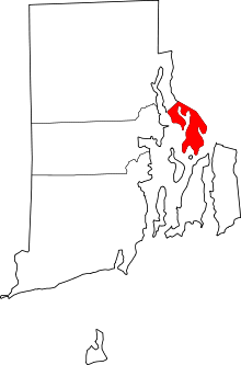
|
| Kent County | 003 | East Greenwich | 1750 | Created from part of Providence County. | County of Kent, England | 166,158 | 168 sq mi (435 km2) | 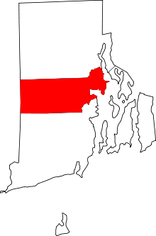
|
| Newport County | 005 | Newport | 1703 | Formed as Rhode Island County in 1703. Renamed Newport County in 1729 | Town of Newport, Essex | 82,888 | 102 sq mi (264 km2) | 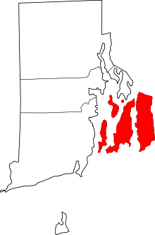
|
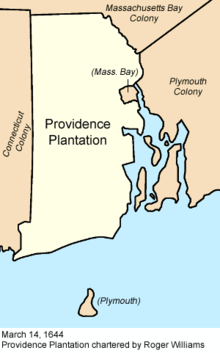
| Providence County | 007 | Providence | 1703 | Formed in 1703 as Providence Plantations County. Renamed Providence County in 1729 | Divine Providence, a concept reflecting the religious nature of colonial founder Roger Williams | 626,667 | 409 sq mi (1,059 km2) | 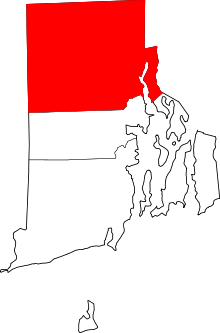
|
| Washington County | 009 | South Kingstown* | 1729 | Formed in 1729 as Kings County from part of Providence Plantations County. Renamed Washington County in 1781. | George Washington, American Revolutionary War general and first President of the USA | 126,979 | 329 sq mi (852 km2) | 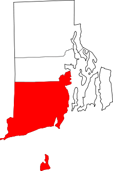 |
Note
- The county seat of Washington County (before county government was abolished) is often referred to as West Kingston. In reality, West Kingston, a village of South Kingstown, does not have its own local government, but because the courthouse was located in West Kingston's zip code, it has become known as the county seat.
References
- ↑ "How Many Counties are in Your State?". 2000. Retrieved 2009-08-26.
- 1 2 3 National Association of Counties. "NACo – Find a county". Archived from the original on 2007-09-30. Retrieved 2007-04-26.
- ↑ "Know Rhode Island". Rhode Island Office of the Secretary of State. Retrieved 2007-08-07.
- ↑ "FIPS Publish 6-4". National Institute of Standards and Technology. Retrieved 2007-04-11.
- ↑ "EPA County FIPS Code Listing". EPA. Retrieved 2007-04-09.
- ↑ "State of Rhode Island General Laws, Chap. 42-3".
- ↑ "Rhode Island Counties and Towns". 2002-12-19. Retrieved 2007-07-08.
- 1 2 "Rhode Island QuickFacts from the US Census Bureau". State & County QuickFacts. Retrieved 2011-10-27.
Providence (capital) | |
| Topics |
|
| Society |
|
| Regions | |
| Cities | |
| Towns |
|