Larne
| Larne | |
| Scots: Lairne[1][2] | |
| Irish: Latharna | |
 A birds-eye view looking south-east towards Larne Harbour, Islandmagee, and down the length of Larne Lough. Chaine Memorial Tower can be seen in the left of the picture, with Ballylumford power station behind the ferry. |
|
 Larne Coat of Arms |
|
 Larne |
|
| Population | 32,180 (2011 Census) |
|---|---|
| Irish grid reference | D4102 |
| – Belfast | 30 km (19 mi) |
| District | Mid and East Antrim |
| County | County Antrim |
| Country | Northern Ireland |
| Sovereign state | United Kingdom |
| Post town | LARNE |
| Postcode district | BT40 |
| Dialling code | 028 |
| Police | Northern Ireland |
| Fire | Northern Ireland |
| Ambulance | Northern Ireland |
| EU Parliament | Northern Ireland |
| UK Parliament | East Antrim |
| NI Assembly | East Antrim |
| Website | www.larne.gov.uk |
|
|
Coordinates: 54°51′04″N 5°48′40″W / 54.851°N 5.811°W
Larne (from Irish: Latharna, the name of a Gaelic terrority)[3][4][5] is a seaport and industrial market town, as well as a civil parish, on the east coast of County Antrim, Northern Ireland with a population of 18,323 people in the 2008 Estimate.[6] As of 2011, there are about 32,000[6] residents in the greater Larne area. It has been used as a seaport for over 1,000 years, and is today a major passenger and freight roll-on roll-off port.[7] Larne is twinned with Clover, South Carolina which has named one of its schools, Larne Elementary School,[8] after Larne. Larne is administered by Mid and East Antrim Borough Council. Together with the neighbouring district of Carrickfergus and part of Newtownabbey, it forms the East Antrim constituency for elections to the Westminster Parliament and Northern Ireland Assembly. The civil parish is situated in the historic barony of Glenarm Upper.[9]
History

The coastal area around Larne has been inhabited for millennia, and it thought to have been one of the earliest inhabited areas of Ireland, with these early human populations believed to have arrived from Scotland via the North Channel. The early coastal dwellers are thought to have had a sophisticated culture which involved trading between the shores of the North Channel and between other settlements on the coasts of Scotland. The coast of Scotland is in fact clearly visible from here. Archaeological digs in the area have found flintwork and other artefacts which have been assigned dates from 6000 BC onwards. The term Larnian has even been coined by archaeologists to describe such flintworks and similar artefacts of the Mesolithic era (and one time to describe Mesolithic culture in Ireland as a whole).[10][11][12] Larnian is also currently used to refer to people from Larne.
The river Inver runs through Larne and was the name of a small village (now area in Larne) to one side of the current Larne town. Its name is an Anglicised spelling of the Irish inbhear, meaning "river-mouth, estuary".
The oldest recorded name for Larne Lough is the Irish Loch Ollarbha (loch meaning "inlet") and Inbhear nOllarbha'. Larne Lough is thought to have bee mentioned by the Roman Emperor Serverus who described how, in 204AD, a Roman slave galley bound for Scotland was blown off course and took shelter in a place that they called Portus Saxa ("Port of the Standing stones").
The name spelt as Latharne was used at one point in reference to the Anglo-Norman cantred of Carrickfergus.[13] Latharna itself means "descendants of Lathar", with Lathar according to legend being a son of the pre-Christian king Úgaine Mór.[14] The area where the modern town sits was known in Irish as Inbhear an Latharna ("rivermouth of Latharna") and was later anglicised as Inver Larne or simply Inver. The territorial name Latharna was only applied exclusively to the location of the present town in recent centuries.
There was Viking activity in the area during the 10th and 11th centuries AD. Viking burial sites and artefacts have been found in the area and dated to that time.[15] Ulfreksfjord was an Old Norse name for Larne Lough. According to the Norse historian Snorri Sturluson, Connor, King of Ireland, defeated Orkney Vikings at Ulfreksfjord in 1018. This was later anglicised as Wulfrickford, Wulfrichford and Wulvricheford. Other Norse-derived names for Larne Lough and the surrounding area are found in various records. They include Woking's Fyrth, Wolderfirth, Wolverflete and Olderfleet. The only one that survives is Olderfleet. The ending -fleet comes from the Norse fljot, meaning "inlet".[16] Older- may come from the Norse oldu, meaning "wave".[16] However, P.W. Joyce in his Irish Names of Places suggests that it comes from Ollarbha, the Irish name for the river.[17]
.jpg)
In the 13th Century the Scots Bissett family built Olderfleet Castle at Curran Point. In 1315 Edward the Bruce of Scotland (brother of Robert the Bruce, King of Scotland) landed at Larne with his 6000 strong army en route to conquer Ireland, where Olderfleet Castle was of strategic importance. Edward saw Ireland as another front in the ongoing war against Norman England.
In 1569 Queen Elizabeth I, Queen of England and Ireland, appointed Sir Moyses Hill as the governor of Olderfleet Castle. It was seen as strategically important for any Tudor conquest of Ulster. Following the 17th century Union of the Crowns of Scotland, England and Ireland under James VI & I many more settlers would have arrived to Ulster via Larne during the Plantation of Ulster. The area around County Antrim itself, however, was not part of the official 17th century Plantation; instead many Scottish settlers arrived in the area through private settlement in the 17th century (as they had also been doing for centuries before).
During the 18th century many Scots-Irish emigrated to America from the port of Larne. A monument in the Curran Park commemorates the Friends Goodwill, the first emigrant ship to sail from Larne in May 1717, heading for Boston, New England in the modern United States. Boston's long standing Scots-Irish roots can be traced to Larne. The town is documented as being the first in county Antrim to be taken by United Irishmen during the ill-fated rebellion of 1798. The Protestant rebels from this area (almost entirely Presbyterian) filled Larne and engaged the government forces around 2am on the morning of the 7th of June. This surprise attack drove the garrison to flee the town, at which point the rebel force marched off to join up with McCracken and fight in the Battle of Antrim.[18]
In 1914, Loyalists opposed to the Home Rule Act 1914 prepared for armed resistance. In an episode known as the Larne Gun Running German, Austrian and Italian weapons with ammunition were transported into the ports of Larne and Bangor in the dead of night and distributed throughout Ulster.[19] This event marked a major step in cementing the right to Ulster Unionist self-determination, with the recognition of such a right ultimately leading to the creation of Northern Ireland.
The Troubles
Larne throughout the course of The Troubles had a significant paramilitary presence in the town, mostly through the presence of the Ulster Volunteer Force (UVF) and Ulster Defence Association (UDA). For further information see UDA South East Antrim Brigade.
The town suffered a number of IRA bomb attacks during The Troubles, notably including a large car bomb at the King's Arms hotel[20] in 1980 that caused damage to the main shopping areas, for which the PIRA claimed responsibility. This incident was raised in Parliament at the time.[21]
Incidents which involved fatalities
- 16 September 1972 Sinclair Johnston a UVF member, was shot by the Royal Ulster Constabulary during street disturbances in the town when the Royal Ulster Constabulary were protecting Catholics living in St Johns Place.[22]
- 20 November 1974:Kevin Regan died from his injuries received in a UVF attack five days before on Maguires bar on Lower Cross Street. The Larne UDA blamed the IRA for the attack.[23]
- 6 February 1975:Colette Brown, a Catholic, was found by the side of the Killyglen Road after being shot by Loyalists.[24] Larnians believe she was murdered by the IRA for having Loyalist sympathies.[25]
- 8 September 1975:Michael O'Toole a Catholic, died from his injuries sustained in a loyalist booby trap bomb attached to his car two days previously.[26]
- 24 August 1980: Rodney McCormick a Catholic and Irish Republican Socialist Party member, was shot dead by the Ulster Defence Association (UDA) in the Antiville area of the town. The Royal Ulster Constabulary convicted the gunmen involved.[27]
- 11 July 2000: Andrew Cairns a UVF member, was killed by members of the UDA[28] at an eleventh night bonfire celebration in a suspected loyalist feud at Boyne Square. He may also have been murdered due to his alleged involvement in an earlier assault.[29] The Royal Ulster Constabulary detective inspector George Montgomery, did not find any motive for the murder. David Ervine(PUP) stated that there was no Loyalist feud.[30]
Geography

In the foreground is Islandmagee in Northern Ireland, followed by Stena Line ferries entering and leaving Larne, and The Maidens lighthouses.
In the background are the Scottish Paps of Jura on the left and Mull of Kintyre on the right.
Larne sits on the western side of a narrow inlet that links Larne Lough to the sea. On the eastern side of the inlet is a peninsula called Islandmagee. To the west of Larne is the ancient volcanic formation of Antrim Plateau, with its glaciated valleys scenically sweeping down to the sea to the north of Larne in what are known as the Glens of Antrim. Larne is 25 miles from the Scottish mainland, with stunning views across the North Channel towards the Mull of Kintyre, Rhins of Galloway, Islay and Paps of Jura often visible from the Larne area – this proximity to Scotland has had a defining influence on Larne's history and culture.
The town is within the small parish of the same name. The following is a list of townlands within Larne's urban area, alongside their likely etymologies:[31]
- Antiville (probably from an Tigh Bhile meaning "the house of the old tree")
- Ballyboley (probably from Baile Buaile meaning "townland of the booley/dairy place")
- Ballycraigy (probably from Baile Creige meaning "townland of the rocky outcrop")
- Ballyloran (probably from Baile Loairn meaning "Loarn's townland")
- Blackcave North
- Blackcave South
- Curran and Drumalis (probably from Córran meaning "crescent" and Druim a' Lios meaning "ridge of the ringfort")
- Greenland ( probably from Green and Land )
- Inver (from Inbhear meaning "rivermouth")

For a list of words relating to Scots language origins, see the Scots derivations category of words in Wiktionary, the free dictionary.
Many streets in Larne end in Brae which comes from the Lowland Scots for Hillside. Here are just 2 of many:
- Whitla's brae
- Casements brae
Civil parish of Larne
The civil parish contains the following townlands:[9] Antiville, Ballyboley, Ballycraigy, Ballyloran, Blackcave North, Blackcave South, Curran and Drumaliss, Glebe, Greenland and Town Parks.

From left to right (panning from West to North): Craigy Hill, Agnew's Hill, Sallagh Braes, Knock Dhu, Scawt Hill, Drains Bay, Ballygally Head, North Channel
Places of interest


_-_geograph.org.uk_-_797992.jpg)
- The town has several parks:[32]
- The Town Park sits above the picturesque Promenade area, with walks from Waterloo Bay towards the Chaine Memorial Tower at Sandy Bay – a lighthouse and memorial to the founder of Larne Harbour sea route to Scotland. The Leisure Centre is nearby. The Promenade leads on to .
- The Chaine Park contains the burial site of James Chaine and offers picturesque views over the North Channel.
- The Curran park has a large children's play area, bowling facilities and camping. There are also tributes to emigrants to North America and Larne's connections with North America.
- The Dixon Park contains a 2 hectare open green space area with bandstand.
- Smiley park is a small park in the centre of the town also with tributes to emigrants to North America who left from the port of Larne.
- Playing fields and cricket grounds at Sandy Bay.
- Carnfunnock Country Park, 3.5 miles north of Larne is a large site with camping, caravanning, gardens, maze of Northern Ireland, sundials, children's play area, mini-golf, 9 hole pitch and putt golf course, clay pigeon shooting, orienteering course, and walks.
- Larne Leisure Centre offers a 25m indoor swimming pool, spa, sauna, weights, fitness, sports hall and theatre. It is situated at Sandy Bay near the picturesque Promenade area.[33]
- Larne Museum & Arts Centre, situated in the Carnegie Centre in the centre of the town.[34]
- Olderfleet Castle is the ruins of a 13th-century castle at Curran Point, near the Chaine Memorial Tower.
- Cairndhu Golf Course is an 18-hole course situated atop of Ballygally Head.[35] Larne Golf Course on sits atop of the Islandmagee peninsula[36]
- Nearby sandy beaches at:
- Sandy Bay (small beach)
- Drains Bay, just to the northern edge of the town.
- Ballygally, 5 miles north from centre of Larne. Ballygally Beach has recently won top awards for cleanliness[37] and is rated to have top water quality for bathing.
- Browns Bay at the tip of Islandmagee offers camping and caravanning.
- Glenarm, 10 miles north from centre of Larne.
- Carnlough, 12 miles north from centre of Larne.
- Waterfalls and forest walk are at nearby Glenoe, 5 miles inland.
- Magheramorne, 5 miles to the south along Larne Lough, has a marina; a Mountainbiking course and an all-Ireland diving centre are currently under construction at the old Magheramorne lime quarry and cement works.[38] The film studio at Magheramorne was used to film much of HBO TV Series Game of Thrones, where the quarry wall was used as a back-drop for much of the series, along with scenery at the Antrim Plateau near Cairncastle.
- Diving tours are also available off the coast. The lighthouse on The Maidens rocks hosts a colony of seals. Numerous coastal bird species and other wildlife such as otters, whales and dolphins are often visible along the Larne coastal area.
- Castle and estate of the Earl of Antrim in the nearby fishing village of Glenarm, 12 miles north, has walled gardens and often hosts Ulster Scots cultural events such as the Dalriada Festival and Highland Games.
- Larne Lough is a protected bird-watching area and designated Special Protection Area, Area of Special Scientific Interest and Ramsar wetland site to protect both birds and shellfish.
- There are numerous stables horse-riding facilities in the area and pony trekking tours are available.
Churches
There are a number of Christian churches in Larne, including the following in alphabetical order:
- All Saints' Church. This Church of Ireland parish church was constructed in 1962 in the then newly built Craigyhill estate[39] with a hall added in 1971. It was originally a "daughter church" of the parish of St Cedma's, before being united with St Patrick's, Cairncastle, to form a new parish grouping.
- Church of God Larne. An Evangelical Pentecostal Church Located in Princes Gardens
- First Larne Presbyterian Church. This Church describes itself "as one of the oldest Presbyterian congregations in Ireland "[40] on its website. It is the home of the Larne music festival.[41]
- Gardenmore Presbyterian Church. Gardenmore is one of three Presbyterian Churches in the town of Larne. Although Presbyterians have been in Larne since the early 1600s, nothing is known about the origins of the congregation, although the church is believed to have been in existence for some years prior to the building of a meeting-house in 1769.
- Larne Baptist Church
- Larne Congregational Church. This church was founded in 1879 by Rev James Orr, but nothing is recorded about other founding members and nothing is known about Rev Orr except that his time as minister lasted for six years until 1885 and that he had died before February 1910 when the new church was built at 38–40 Curran road. Before this there was an old tin/iron building on the Clonlee which was the original meeting place. It was known as the tin tabernacle. After it became unusable due to rust and decay, the church members met at 139 Main street in the town and some meetings were held in Rev Archibald Mackinlay's home at 20 Clonlee. Around this time (1900 approx) monthly meetings were being held in the Intermediate school at Barnhill. This school was actually the end house in the terrace beside the Orange hall and is now a house again.
- Larne Elim Pentecostal
- Larne Free Presbyterian Church
- Larne Methodist Church. This Church is one of three and is the main Methodist Church on the Larne Circuit. The other Churches on the circuit are Craigyhill and Carnlough Methodist Churches. The Methodist Church in Larne has maintained a presence in the town ever since visits from the founder of the Methodist Church Rev John Wesley. Methodism seeks to be "a friend to all and an enemy to none" and this is what the Larne circuit has tried to achieve through many years of ministry. The Methodist Church throughout the circuit is involved in many community and ecumenical organisations throughout the town. The previous Superintendent the Rev Andrew Kingston was always in awe of the great relationship this group built up between the churches in Larne.
- Larne Seventh-Day Adventist Church
- Old Presbyterian Church of Larne and Kilwaughter
- St. Anthony's Church
 St. MacNissi's Church, Larne
 - St. Cedma's Parish Church. The oldest church in Larne is the St. Cedma's Church, the local Anglican or Church of Ireland parish church. Records show a church in the area going back to the 12th century,[42] with the current building dating from around 1350.[43] The Church has a traditional lychgate, made of Burma teak, which leads into the graveyard, featuring headstones dating back as far as 1677.[44] The Most Reverend Alan Buchanan served in the parish before being elevated to the position of Archbishop of Dublin. The site is believed to have once contained a friary.[45]
- St. MacNissi's Church. This Catholic Church was built in 1857–59 and celebrated its 150th anniversary in 2009. It was built with basalt and sandstone dressings. It was designed by Robert Young of Belfast. There has been a church here since 1831, erected shortly after the Catholic Emancipation Act of 1829, but proved to be too small. Enlargements were made in 1905 and a thorough restoration was carried out in 1993.
Demography
Larne is classified as a Large Town by the Northern Ireland Statistics and Research Agency (NISRA)[46]
On Census Day 27 March 2011, in Larne Local Government District, considering the resident population:
- 0.60% were from an ethnic minority population and the remaining 99.40% were white (including Irish Traveller);
- 24.87% belong to or were brought up in the Catholic religion and
- 68.16% belong to or were brought up in a 'Protestant and Other Christian (including Christian related)' religion;
- 69.81% indicated that they had a British national identity,
- 10.10% had an Irish national identity and
- 31.35% had a Northern Irish national identity*.
Respondents could indicate more than one national identity On Census Day 27 March 2011, in Larne Local Government District, considering the population aged 3 years old and over:
- 19.20% had some knowledge of Ulster Scots;
- 4.39% had some knowledge of Irish;
- 0.79% did not have English as their first language.[47]
Industry and commerce

- Ballylumford power station – Northern Ireland's main power station, providing half of all Northern Ireland's electricity.
- Headquarters of Caterpillar (NI) Limited (part of the Caterpillar group) – a major employer in Northern Ireland and manufacturer of diesel and gas generators.[48]
- InspecVision Ltd. – Industrial Inspection Equipment.
- Terumobct – Japanese manufacturer of intravenous drip solutions and blood products.[49]
- LEDCOM (Larne Enterprise Development Company) and business park[50]
- B9 Energy – renewable energy development[51]
- Wind NI – Wind Power Development Solutions
A variety of shops can be found mainly along Larne Main Street, Dunluce Street, Laharna Retail Park, and large supermarkets off the Harbour Highway near the harbour. A variety market is also held every Wednesday at the Larne Market Yard.[52]
Transport
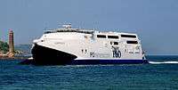
- Ferries sail from the harbour to Cairnryan in Scotland. Passenger services are operated by P&O Irish Sea which describes the crossings from Larne to Scotland as "the shortest, fastest crossings" due to the close proximity that Larne has to Scotland.
- Larne is connected to Belfast by the A8 road. The A2 road or 'Antrim coast road' which runs along the Antrim coast, and passes through the scenic Glens of Antrim, also serves the town. South of the town the A2 passes the side of Larne Lough, via Glynn, Magheramorne, and Ballycarry, to Whitehead and Carrickfergus. The A36 road runs from the town to Ballymena.
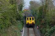
- The Belfast–Larne railway line connects to Belfast Great Victoria Street railway station and Belfast Central, via Whitehead, Carrickfergus and Jordanstown, also connects Larne to the Northern Ireland Railways network. Currently there is no freight transport by rail in Northern Ireland. Both Larne Town railway station and Larne Harbour railway station opened on 1 October 1862 and closed for goods traffic on 4 January 1965.[53]
- The Ballymena and Larne Railway was a narrow gauge railway. It opened in 1878, was closed to passengers in 1933 and finally completely closed in 1950. Another line ran from Larne to Ballyclare and some parts of it can still be made out where it ran along the Six Mile valley.
|


Education
There are a number of educational establishments in the area:
Primary Schools:
- Antiville Primary School
- Cairncastle Primary School
- Corran Integrated Primary School
- Glynn Primary School
- Linn Primary School
- Larne & Inver Primary School
- Moyle Primary School
- Olderfleet Primary School
- St. Anthony's Primary School
- St. Macnissi's Primary School
- St. Mary's Primary School
- Toreagh Primary School
Secondary Schools:
- Larne Grammar School
- Larne High School
- St Killian's College, Garron Tower (recent amalgamation of St. Comgall's College and St. MacNissi's College, Garron Tower)
Further education:
- Northern Regional College (formerly Larne Technical College)
Public Services

- Larne Fire Station
- Larne Library
- Larne Police Station
- Larne Ambulance Station
- Moyle Hospital (limited services after closure of accident & emergency)
- RNLI Larne Lifeboat Station
Larne Harbour Police
Larne Harbour Police is a small specialised police force, with approximately seven officers,[54] responsible for policing Larne Harbour 24 hours per day.[55] The officers of the force are sworn in as special constables under the Harbours, Docks, and Piers Clauses Act 1847, and are responsible to Larne Harbour Ltd. Jurisdiction of the constables extends to one mile beyond the Harbour Complex.[56] The force are subject to the oversight of the Police Ombudsman for Northern Ireland.[57]
Notable people
- Smiley Baronets, series of baronets important in History of Larne
- Dianne Barr, Paralympic Swimmer
- Aaron Black, Footballer
- Billy Brown, Musician
- James Chaine Member of parliment and Lairne's Tower, Chaine Memorial Tower.
- Dave Clements, Footballer and football manager.
- Fyfe Ewing, Musician, Drummer, formerly with rock band Therapy?
- Robert Ferguson, Disc jockey
- Keith Gillespie, Sheffield United and Northern Ireland midfielder.
- Mark Haggan, Businessman & Charity activist
- Richard Hayward, actor, singer and author
- Valerie Hobson, actress
- Jeff Hughes, Footballer
- Michael Hughes, Wimbledon and Coventry City footballer
- Whitford Kane, actor of stage and screen
- Valerie Lilley, actor from TV programme Shameless
- Phillip Magee, The X Factor (UK series 2) finalist.
- Sir Ivan Magill, innovating anaesthetist, went to Larne Grammar school
- Dave McAuley, former IBF Flyweight world champion boxer.
- Gareth McAuley, current West Bromwich Albion defender.
- Adam McGurk, Professional Footballer
- Bobby McKee, Democratic Unionist Party councillor and former Mayor of Larne[58]
- Jack McKee, Alderman and Veteran Loyalist politician and brother of Bobby.
- Michael McKeegan, Musician, with rock band Therapy?
- Amanda McKittrick Ros, author and poet taught at Millbrook National School in the 1880s.
- Eddie McMorran, Footballer
- Eddie Mooney, Musician, with The Dakotas and The Fortunes.
- Hugh Nelson, Lieutenant Governor of British Columbia (1830–1893).
- Robert Nelson, electronic music producer making up half of Agnelli & Nelson.
- Jonathan Rea, world superbike rider
- Keith Semple of One True Voice from the ITV series Popstars The Rivals.
- Harry Towb, Actor
Notable facts
- Larnite - this mineral is named after larne [59]
Freedom of the borough
In memory of a battle in the town of Musa Qala in Afghanistan in 2006, involving the Royal Irish Regiment, a new regimental march, composed by Chris Attrill and commissioned by Larne Borough Council, was gifted to the regiment on Saturday 1 November 2008 in Larne, during an event in which the regiment was also presented with the 'Freedom of the Borough'.
This gave the regiment the right to march through the towns of the borough with 'flags flying, bands playing and bayonets fixed'. The march was named Musa Qala.[60]
Sport
- Larne F.C.
- Larne Technical Old Boys F.C.
- Wellington Recreation F.C.
- Larne R.F.C.
- Larne Hockey Club[dead link]
- Larne Cricket Club
- Larne Golf Club
- Cairndhu Golf Club
- Cairndhu Rowing Club
- East Antrim Boat Club
- Larne Boat Club[dead link]
- Larne Bowling & Lawn Tennis Club
- Larne Athletics Club
- Larne Swimming Club
- Larne & District Game Angling Association
See also
| Wikimedia Commons has media related to Larne. |
References
- ↑ Dunluce Castle (Ulster-Scots translation) DOE. Retrieved 28 September 2011.
- ↑ [Leaf through the Online Scots Dictionary http://www.scots-online.org/dictionary/read.asp?letter=L&CurPage=4]
- ↑ Larne/Latharna. Placenames Database of Ireland.
- ↑ Postal Towns/Bailte Poist. Northern Ireland Place-Name Project. Queen's University Belfast.
- ↑ Room, Adrian. Placenames of the World. McFarland, 2006. p.213
- 1 2 Local Government District information for Larne
- ↑ Port of Larne:History
- ↑ Elementary School Homepage
- 1 2 "Larne". IreAtlas Townlands Database. Retrieved 20 April 2015.
- ↑ Larne Borough council – Local History and Heritage
- ↑ Larnian – Oxford Dictionary of Archaeology
- ↑ Larnian industry – Encyclopædia Britannica
- ↑ MacCotter, Paul. Medieval Ireland. Territorial, Political and Economic Divisions. The Heritage Council. ISBN 9781846825576.
- ↑ Place Names Northern Ireland. "Larne, County Antrim". Retrieved 29 August 2016.
- ↑ Danish Viking Ship Museum – Larne Viking Grave
- 1 2 Geoffrey Malcolm Gathorne-Hardy. The Norse Discoverers of America. Clarendon Press, 1921.
- ↑ Irish Times – Where's That?/Olderfleet 1365
- ↑ Hope, J., & Newsinger, J. (2001). United Irishman : the autobiography of James Hope: The autobiography of James Hope. p33-34 London: Merlin.
- ↑ A. T. Q. Stewart: "The Ulster Crisis", London, Faber and Faber Ltd., 1967 SBN 571 08066 9
- ↑ Report on King's Arms Hotel bombing
- ↑ Hansard commentary on King's Arms Hotel bombing being raised in Westminster
- ↑ David McKittrick et al Lost Lives page 264-265
- ↑ David McKittrick et al Lost Lives page 495-496
- ↑ David McKittrick et al Lost Lives page 514-515
- ↑ David McKittrick et al Lost Lives page 366
- ↑ David McKittrick et al Lost Lives page 575-576
- ↑ David McKittrick et al Lost Lives page 836
- ↑ UVF man shot as loyalists fall out | UK news | The Guardian http://www.theguardian.com/uk/2000/jul/13/northernireland.jamiewilson
- ↑ David McKittrick et al Lost Lives page 1478-1479
- ↑ BBC News | NORTHERN IRELAND | Fresh appeal after bonfire murder
- ↑ "Northern Ireland Placenames Project". Retrieved 2010-06-12.
- ↑ Larne Borough Council overview
- ↑ Leisure Centre
- ↑ Larne Museum & Arts Centre
- ↑ Cairndhu Golf Club
- ↑ Larne Golf Club
- ↑ Ballygally and Carnlough beaches win UK awards
- ↑ Magheramorne reinvented by Lafarge
- ↑ Diocese of Connor website including All Saints' Church
- ↑ First Larne Presbyterian Church Website
- ↑ "Larne Music Festival hits the right note". Larne Times.
- ↑ St. Cedma's Parish church website
- ↑ The Diocese of Connor page on St. Cedma's Church, Larne
- ↑ Pictures of St. Cedma's Parish Church
- ↑ Larne Council website featuring Saint Cedma's Parish Church
- ↑ NI Statistics and Research Agency website.
- ↑ NI Neighbourhood Information Service
- ↑ FG Wilson (Engineering) Ltd.
- ↑ TerumoBCT home page
- ↑ LEDCOM
- ↑ B9 Energy
- ↑ Larne Borough Council – Larne Market
- ↑ "Larne stations" (PDF). Railscot – Irish Railways. Retrieved 2007-08-28.
- ↑ Police Service of Northern Ireland, retrieved 2008-06-28
- ↑ "Passenger > Services". Website of Larne Harbour. Larne Harbour Limited. Retrieved 18 May 2011.
- ↑ Hansard Report 5 June, 2006
- ↑ "Code of Ethics" (PDF). Police Ombudsman for Northern Ireland. Retrieved 18 May 2011.
- ↑ "Bobby McKee elected new Mayor of Larne". Larne Times. Johnston Publishing. 12 June 2008. Retrieved 11 August 2014.
- ↑ http://webmineral.com/data/Larnite.shtml Larnite Monerl Data and Location found
- ↑ Freedom of the Borough
Further reading
- Cowsill, Miles (1998). Stranraer–Larne: The Car Ferry Era. Narberth, Pembrokeshire: Ferry Publications. ISBN 1871947405.
External links
| Large |  | |
|---|---|---|
| Medium | ||
| Small | ||
Italics denote settlements that are classed as towns but also have city status | ||