Dundonald
| Dundonald | |
| Scots: Dundonal or Dundoanal[1][2] | |
| Irish: Dún Dónaill | |
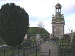
 Dundonald Moat and St Elizabeth's Church |
|
 Dundonald |
|
| Population | 16,098 (2011 Census) |
|---|---|
| District | Lisburn and Castlereagh |
| County | County Down |
| Country | Northern Ireland |
| Sovereign state | United Kingdom |
| Post town | BELFAST |
| Postcode district | BT16 |
| Dialling code | 028 |
| EU Parliament | Northern Ireland |
| UK Parliament | Belfast East |
| NI Assembly | Belfast East |
|
|
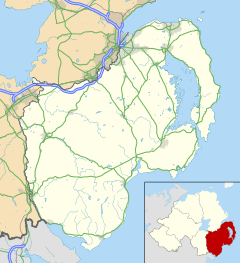
Coordinates: 54°35′38″N 5°48′47″W / 54.594°N 5.813°W
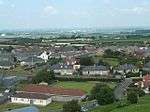
Dundonald (from Irish: Dún Dónaill, meaning "Dónall's stronghold")[3] is a large settlement and civil parish in County Down. It lies east of Belfast and is often deemed to be a suburb of the city. It includes the large housing estate of Ballybeen, and many new housing developments have emerged in the past ten years.
History
Dundonald refers to a 12th-century Norman fort, or Dún, Dún Dónaill, that stood in the town. One of the largest in Ireland, the man-made hill that the fort stood on is still in existence.
Although the mound is commonly referred to as 'the moat' this is, in fact, a corruption of the word 'motte' and refers to the fact that this defensive structure was built in the style of a motte and bailey. St. Elizabeth's Church is located beside the moat, with the Cleland Mausoleum in the adjacent graveyard.[4]
Dundonald acquired rail links to Belfast and Newtownards in 1850, Downpatrick in 1859 and Newcastle in 1869. The town was located on the once extensive Belfast and County Down Railway mainline. The rail link with Belfast encouraged Dundonald to expand as a commuter town, but in 1950 the railway line running through Dundonald was closed. Dundonald railway station was opened on 6 May 1850, but finally closed on 24 April 1950.[5] In the 1960s, Dundonald was deemed a small village.[6] A number of property developments, most notably the housing estate Ballybeen, were then built and Dundonald's population rapidly grew.[7]
Demography
For census purposes, Dundonald is not treated as a separate entity by the NI Statistics and Research Agency (NISRA).[8] Instead, it is combined with a large part of east and southeast Belfast to form the "Castlereagh Urban Area". A fairly accurate population count can be found by combining the data of the electoral wards that make up Dundonald. These wards are Ballyhanwood 1, Carrowreagh, Dundonald, Enler, and Grahams Bridge. However, the wards also include part of the countryside surrounding Dundonald.
On the day of the last census (27 March 2011), the combined population of these wards was 16,098 . This is within the bounds of the medium-sized town (a population between 10,000 and 18,000).
Of this population:
- 71.3% were Protestant or from a Protestant background
- 3.6 were Catholic or from a Catholic background
- 25.1% were of other religious backgrounds or no religious background.[9]
Governance
Dundonald is represented in council governance by the Castlereagh East DEA. The members elected in 2014 were:
| Name | Party | |
|---|---|---|
| Tommy Jeffers | DUP | |
| Tim Morrow | Alliance | |
| David Drysdale | DUP | |
| Andrew Girvin | TUV | |
| Sharon Skillen | DUP | |
| Hazel Legge | UUP | |
Townlands
Dundonald sprang up within the small parish of the same name. Like the rest of Ireland, this parish has long been divided into townlands, whose names mostly come from the Irish language. Over time, more rural townlands have been built upon and they have given their names to many roads and housing estates. The following is a list of townlands within Dundonald's urban area, alongside their likely etymologies:[10]
- Ballybeen (likely from Baile Binne meaning "townland of the peak" or Baile Bín meaning "Bín's townland")
- Ballymiscaw (likely from Baile Lios na Scáth meaning "townland of the fort of shadows")
- Ballyoran (likely from Baile Fhuaráin meaning "townland of the spring")
- Ballyregan (likely from Baile Uí Riagáin meaning "Ó Riagáin's townland")
- Carrowreagh (likely from an Cheathrú Riabhach meaning "the speckled quarterland")
- Dunlady (likely from Dún Léide meaning "Léide's stronghold")
Places of interest
The Comber Greenway is a direct traffic free link into Belfast and it passes through Dundonald. It is enjoyed by thousands of cyclists and walkers on a daily basis.
In 1986, The Dundonald International Ice Bowl was opened in the town. This originally comprised an Olympic sized ice rink and a 20 lane AMF ten pin bowling alley. In later years, "Indianaland", a children's Aztec themed indoor adventure playground was added along with Laser Quest, a simulated combat arena using laser tag equipment. The bowling alley was upgraded to 30 lanes in the 1990s and an extensive miniature golf course has recently been built. The site also contains a David Lloyd fitness centre. In 2006, the area was designated as the Dundonald Leisure Park, as part of the Draft Belfast Metropolitan Area Plan 2015. In 2008, an Omniplex cinema was built on the opposite side of the Old Dundonald Road, together with several leisure and restaurant units.[11]
The Ulster Hospital is located in Dundonald, known colloquially as "The Ulster".
Sport
Donard Hospital F.C. and Dundonald F.C. play association football in the Northern Amateur Football League.
A number of local football teams play out of Dundonald, Dundonald FC playing in 1A and 3C of the National Amateur League and "Moat Park Rangers" and "43RD Old Boys" playing in the Down Area Winter Football League are the three clubs that are well known in the town. Dundonald FC is one of the oldest running amateur league clubs in Northern Ireland, established in 1953.
From 1928 to 1936, the RAC Tourist Trophy (TT) motorcar races took place on a (closed) road circuit encompassing Newtownards, Comber and Dundonald in County Down, run in a clockwise direction.[12] The pits were still visible up until the 1960s. A popular viewing point was the hairpin bend at the Central Bar in Dundonald. Industrialist and pioneer of the modern agricultural tractor, Harry Ferguson, was instrumental in setting up the race, which was known as the Ards TT.
At the time, it was Northern Ireland's premier sporting event, regularly attracting crowds in excess of a quarter of a million people. Although it was a speed event, the entries were handicapped to allow cars of very different sizes and capabilities to race against each other on supposedly even terms over 30 laps (35 laps from 1933) of the 13.7-mile circuit. On 5 September 1936, in wet conditions, local driver Jack Chambers lost control of his Riley and crashed into the crowd, killing eight spectators. This tragedy brought an end to nine years of racing over the Ards road circuit.[12][13]
The town's ice rink, the Dundonald Ice Bowl is home to the Irish Ice Hockey League's Junior Belfast Giants.
People
- Noel Brotherston, former footballer
- Vivian Campbell, guitarist Def Leppard
- Davy Larmour, Crusaders footballer
- Colin Murray, BBC Radio 1 DJ
- Peter and Iris Robinson, politicians
- Chris Walker, Glentoran footballer
- Gemma Garrett Model, Current Miss Great Britain and Miss Belfast
- Anne Gregg, BBC presenter and travel writer
- Paddy Wallace, Rugby union footballer
- Micky Modelle, DJ
- Michael Moore, UK politician – Born in town.
- Glenn Ferguson Linfield footballer
- Agnes Romilly White, writer
Civil parish of Dundonald
The civil parish contains the settlement of Dundonald.[14]
Townlands
The civil parish contains the following townlands:[14]
- Ballybeen
- Ballylisbredan
- Ballymiscaw
- Ballyoran
- Ballyrainey
- Ballyregan
- Carrowreagh
- Castlebeg
- Church Quarter
- Dunlady
- Killeen
- Unicarval
Gallery
|


See also
| Wikimedia Commons has media related to Dundonald. |
References
- ↑ 2002 annual report in Ulster-Scots NSMC.
- ↑ Hannlin Rede 2012-2013. DARD. Retrieved 21 August 2012.
- ↑ Placenames Database of Ireland
- ↑ Marshall, J.J. 'The Romance of Dundonald, a fortress seized by King John,' Baird (Belfast, 1929).
- ↑ "Dundonald station" (PDF). Railscot – Irish Railways. Retrieved 5 September 2007.
- ↑ Carr, Peter,'The Most Unpretending of Places, a History of Dundonald, County Down'white Row Press, (Dundonald, 1987), p.181,211
- ↑ Carr, Peter,'The Most Unpretending of Places, a History of Dundonald, County Down'white Row Press, (Dundonald, 1987), p.214
- ↑ NI Statistics and Research Agency (NISRA) Official web site
- ↑ Northern Ireland Census 2011 – Religion or Religion Brought Up In: KS212NI (administrative geographies). Northern Ireland Statistics and Research Agency (NISRA).
- ↑ "Northern Ireland Placenames Project". Retrieved 12 June 2010.
- ↑ Castlereagh Borough Council
- 1 2 "The Tourist Trophy Races". Culture Northern Ireland. Retrieved 9 October 2009.
- ↑ "Memorial revives Ards TT memories". BBC. 18 August 2008. Retrieved 5 January 2009.
- 1 2 "Dundonald". IreAtlas Townlands Database. Retrieved 16 May 2015.
External links
| Large |  | |
|---|---|---|
| Medium | ||
| Small | ||
Italics denote settlements that are classed as towns but also have city status | ||