Kilconway
| Kilconway Coill Chonmhaí[1] (Irish) | |
|---|---|
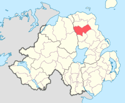 Location of Kilconway, County Antrim, Northern Ireland. | |
| Sovereign state | United Kingdom |
| Country | Northern Ireland |
| County | Antrim |
Kilconway (from Irish: Coill Uí Chonmhaí[2]) is a barony in County Antrim, Northern Ireland.[3] It is bordered by six other baronies: Dunluce Upper to the north; Glenarm Lower to the east; Antrim Lower to the south-east; Toome Lower to the south; Loughinsholin to the south-west; and Coleraine to the north-east.[3] Kilconway also formed part of the medieval territory known as the Route. Springmount Bog is located within the barony.[1]
History
Main article: The Route
List of settlements
Below is a list of settlements in Kilconway:[1]
Villages
Population centres
- Clogh
- Finvoy
- Glarryford
- Glenravel
- Killagan
- Loughguile (part in barony of Dunluce Upper)
- Newtown Crommelin
List of civil parishes
Below is a list of civil parishes in Kilconway:[4][5]
- Ballymoney (also partly in barony of Dunluce Upper, County Antrim and North East Liberties of Coleraine, County Londonderry)
- Craigs (split with barony of Toome Lower)
- Dunaghy
- Finvoy
- Grange of Dundermot
- Killagan (split with barony of Dunluce Upper)
- Loughguille (split with barony of Dunluce Upper)
- Rasharkin
- Newtown Crommelin
References
- 1 2 3 "Kilconway". Placenames Database of Ireland. Department of Community, Rural and Gaeltacht Affairs. Retrieved 5 June 2011.
- ↑ "Kilconway, County Antrim". Place Names Northern Ireland. Retrieved 6 February 2014.
- 1 2 PRONI Baronies of Northern Ireland
- ↑ PRONI Civil Parishes of County Antrim
- ↑ Baronies and parishes of County Antrim
This article is issued from Wikipedia - version of the 4/20/2015. The text is available under the Creative Commons Attribution/Share Alike but additional terms may apply for the media files.