Toome Upper
| Toome Upper Tuaim Uachtarach[1] (Irish) | |
|---|---|
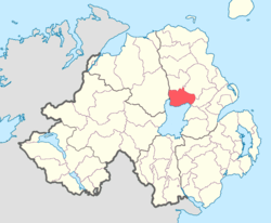 Location of Toome Upper, County Antrim, Northern Ireland. | |
| Sovereign state | United Kingdom |
| Country | Northern Ireland |
| County | Antrim |
Toome Upper is a barony in County Antrim, Northern Ireland.[2] To its south lies Lough Neagh, and it is bordered by five other baronies: Toome Lower to the north; Antrim Lower to the north-east; Antrim Upper to the east; Massereene Lower to the south-east; and Loughinsholin to the south-east.[2] Toome Upper also formed part of the medieval territories known as the Route and Clandeboye.
History
Main articles: The Route and Clandeboye
List of settlements
Below is a list of settlements in Toome Upper:[1]
Towns
- Ahoghill (also part of baronies of Toome Lower and Antrim Lower)
- Antrim (also part of barony of Toome Lower)
- Milltown
- Randalstown
Population centres
- Crosskeys
- Toome
- Newferry
- Whiteside's Corner
List of civil parishes
Below is a list of civil parishes in Toome Upper:[3][4]
- Antrim (split with barony of Antrim Upper)
- Ballyscullion (split with barony of Loughinsholin)
- Cranfield
- Drummaul
- Duneane
- Grange of Ballyscullion
- Grange of Shilvodan
References
- 1 2 "Toome Upper". Placenames Database of Ireland. Department of Community, Rural and Gaeltacht Affairs. Retrieved 5 June 2011.
- 1 2 PRONI Baronies of Northern Ireland
- ↑ PRONI Civil Parishes of County Antrim
- ↑ Baronies and parishes of County Antrim
This article is issued from Wikipedia - version of the 5/3/2015. The text is available under the Creative Commons Attribution/Share Alike but additional terms may apply for the media files.