Lar National Park
Lar National Park (Persian پارک ملی لار park-e melli-e lar) is a protected area in Mazandaran Province and Tehran Province, in northern Iran.
Geography
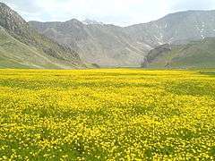

The 30,000-hectare (74,000-acre) park is in the Central Alborz mountain range, at the foot of Mount Damavand.[1]
It has been a national park since 1976 and a protected area since 1982 by the Iran Department of Environment. Since 1991 hunting has been prohibited.[2][3]
The Lar Dam and reservoir is located within the park. It is a major tourist attraction, being only 70 kilometres (43 mi) northeast of Tehran.
The park is accessible by car via Haraz road (Road 77).
Flora and fauna
One of the rare species of the Salmonidae family of fish is native to this area. Other notable flora and fauna of the park are:
- Plants: liquorice, Cichorium, Thymus vulgaris, Heracleum persicum, St John's wort, borage, shallot, galbanum and multiple species of fungus
- Birds: grey partridge, cormorant, heron and eagle
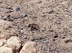
- Mammals: goat, leopard, gray wolf, bear, wild boar, jackal and fox
- Herpetofauna: monitor lizard, lizard and frog
Central Alborz mountain range map
| Map of central Alborz | Peaks: | 1 `Alam Kūh |
|---|---|---|
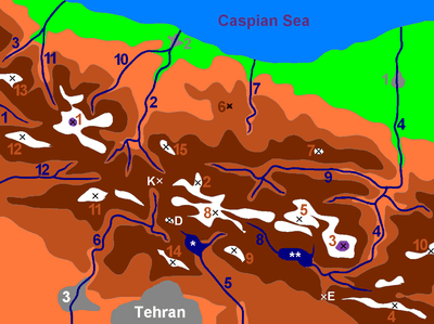 -25 to 500 m 500 to 1500 m 1500 to 2500 m 2500 to 3500 m 3500 to 4500 m 4500 to 5671 m |
2 Āzād Kūh | 3 Damāvand |
| 4 Do Berar | 5 Do Khaharan | |
| 6 Ghal`eh Gardan | 7 Gorg | |
| 8 Kholeno | 9 Mehr Chal | |
| 10 Mīšīneh Marg | 11 Naz | |
| 12 Shah Alborz | 13 Sīālān | |
| 14 Tochal | 15 Varavašt | |
| Rivers: | 0 | |
| 1 Alamūt | 2 Chālūs | |
| 3 Do Hezār | 4 Harāz | |
| 5 Jājrūd | 6 Karaj | |
| 7 Kojūr | 8 Lār | |
| 9 Nūr | 10 Sardāb | |
| 11 Seh Hazār | 12 Shāh Rūd | |
| Cities: | 1 Āmol | |
| 2 Chālūs | 3 Karaj | |
| Other: | D Dīzīn | |
| E Emāmzādeh Hāšem | K Kandovān Tunnel | |
| * Latīān Dam | ** Lār Dam |
References
- ↑ "Lar National Park". ProtectedPlanet. Retrieved 2012-05-20.
- ↑ "پارک ملی لار - Irandeserts database". Irandeserts.com. Retrieved 2012-05-20.
- ↑ "آشنایی با پارک ملی لار - Hamshahri newspaper". Hamshahrionline.ir. Retrieved 2012-05-20.
External links
| Wikimedia Commons has media related to Lar National Park. |
Coordinates: 35°59′06″N 51°58′45″E / 35.9851°N 51.9791°E