Latyan Dam
| latyan Dam | |
|---|---|
.jpg) | |
 Location of latyan Dam in Iran | |
| Official name | سد لتیان |
| Location | Lavasan, Tehran Province, Iran |
| Coordinates | 35°47′24.25″N 51°40′42.63″E / 35.7900694°N 51.6785083°ECoordinates: 35°47′24.25″N 51°40′42.63″E / 35.7900694°N 51.6785083°E |
| Purpose | Water supply, power |
| Construction began | 1963 |
| Opening date | 1967 |
| Dam and spillways | |
| Impounds | Jajrood River |
| Height | 107 m (351 ft) |
| Length | 450 m (1,480 ft) |
| Width (base) | 99 m (325 ft) |
| Reservoir | |
| Total capacity | 95,000,000 m3 (77,000 acre·ft) |
| Power station | |
| Commission date | 1969/1987 |
| Type | Conventional |
| Turbines | 2 x 22.5 MW |
| Installed capacity | 45 MW |
Latyan Dam (Persian: سد لتيان, also Romanized as Sadd-e Latyān) is a buttress dam on the Jajrood River, located less than 25 km from Tehran in the south of city of Lavasan. It is one of the main sources of water for Tehran metropolitan region. It was constructed between 1963 and 1967. The first generator in the dam's 45 MW hydroelectric power station was commissioned on 17 March 1969, the second on 13 April 1987.[1]
Geology
Jajrood River basin is located in the southern part of central Alborz mountain range, the rocks of which date from the Palaeozoic era up to the Quaternary period, as below:
- Palaeozoic era: The dolomitic rocks, sandstone and limestone. Belong to Devonian, Carboniferous and Permian periods.
- Mesozoic era: The sandstone formation and limestones of Teriace and Shemshak (Lower Jurassic) coal formation with sandstone and fossiliferous limestones belong to this era.
- Paleogene period: starts with lower and middle Eocene limestone layers with nummulite fossil and continues with the Alborz green layers. (Green tuffs) which is an indication of submarine volcanic, eruptions and were belongs to upper Eocene.
- Quaternary period: The basaltic masses in the alluvial deposits which cover a big area in the region belong to this era.
Location within Alborz Range
| Map of central Alborz | Peaks: | 1 `Alam Kūh |
|---|---|---|
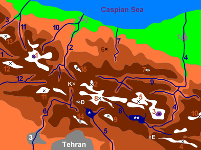 -25 to 500 m 500 to 1500 m 1500 to 2500 m 2500 to 3500 m 3500 to 4500 m 4500 to 5671 m |
2 Āzād Kūh | 3 Damāvand |
| 4 Do Berar | 5 Do Khaharan | |
| 6 Ghal`eh Gardan | 7 Gorg | |
| 8 Kholeno | 9 Mehr Chal | |
| 10 Mīšīneh Marg | 11 Naz | |
| 12 Shah Alborz | 13 Sīālān | |
| 14 Tochal | 15 Varavašt | |
| Rivers: | 0 | |
| 1 Alamūt | 2 Chālūs | |
| 3 Do Hezār | 4 Harāz | |
| 5 Jājrūd | 6 Karaj | |
| 7 Kojūr | 8 Lār | |
| 9 Nūr | 10 Sardāb | |
| 11 Seh Hazār | 12 Shāh Rūd | |
| Cities: | 1 Āmol | |
| 2 Chālūs | 3 Karaj | |
| Other: | D Dīzīn | |
| E Emāmzādeh Hāšem | K Kandovān Tunnel | |
| * Latīān Dam | ** Lār Dam |
References
- ↑ "Installed Capacity ,Plants Site,Fuel Type,Date of Commissioning of Power Plants". Tavinar. Retrieved 19 January 2015.
External links
This article is issued from Wikipedia - version of the 8/23/2016. The text is available under the Creative Commons Attribution/Share Alike but additional terms may apply for the media files.