Mount Damavand
| دماوند Damāvand | |
|---|---|
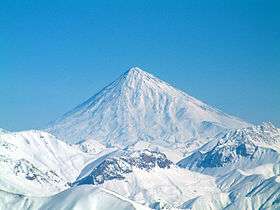 Damāvand during winter | |
| Highest point | |
| Elevation | 5,610 m (18,410 ft) [1][2][3] |
| Prominence |
4,667 m (15,312 ft) [2][4] Ranked 12th |
| Isolation | 1,165 kilometres (724 mi) |
| Parent peak | Mount Elbrus [5] |
| Listing |
Volcanic Seven Summits Country high point Ultra |
| Coordinates | 35°57′20″N 52°06′36″E / 35.95556°N 52.11000°ECoordinates: 35°57′20″N 52°06′36″E / 35.95556°N 52.11000°E [4] |
| Geography | |
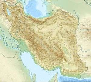 دماوند Damāvand Location in Iran | |
| Location | Amol, Māzandarān, Iran |
| Parent range | Alborz |
| Geology | |
| Mountain type | Stratovolcano |
| Last eruption | 5350 BCE ± 200 years |
| Climbing | |
| First ascent | 905 by Abu Dolaf Kazraji[6] |
| Easiest route | Hike |
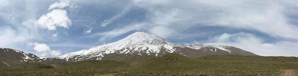
Mount Damāvand (Persian: دماوند [dæmɒːvænd]), a potentially active volcano, is a stratovolcano which is the highest peak in Iran and the Middle East as well as the highest volcano in Asia (the Kunlun Volcanic Group in Tibet has a higher elevation than Damāvand, but are not considered to be volcanic mountains).[7][8] It has a special place in Persian mythology and folklore. This peak is located in the middle of the Alborz range, adjacent to Varārū, Sesang, Gol-e Zard and Mīānrūd. The mountain is located near the southern coast of the Caspian Sea, in Amol County, Mazandaran Province, 66 kilometres (41 miles) northeast of the city of Tehran.[9]
Mount Damāvand is the 12th most prominent peak in the world, and the second most prominent in Asia after Mount Everest. It is the highest volcanic mountain in Asia, and part of the Volcanic Seven Summits mountaineering challenge.
Symbolism and mythology
Damavand is a significant mountain in Persian mythology. It is the symbol of Iranian resistance against despotism and foreign rule in Persian poetry and literature. In Zoroastrian texts and mythology, the three-headed dragon Aži Dahāka was chained within Mount Damāvand, there to remain until the end of the world. In a later version of the same legend, the tyrant Zahhāk was also chained in a cave somewhere in Mount Damāvand after being defeated by Kāveh and Fereydūn. Persian poet Ferdowsi depicts this event in his masterpiece, the Shahnameh:
بیاورد ضحاک را چون نوند
به کوه دماوند کردش ببند
He brings Zahhak, himself a mountain
to the peak of Damavand and binds his neck.
The mountain is said to hold magical powers in the Shahnameh. Damāvand has also been named in the Iranian legend of Arash (as recounted by Bal'ami) as the location from which the hero shot his magical arrow to mark the border of Iran, during the border dispute between Iran and Turan. The famous poem Damāvand by Mohammad Taqī Bahār is also one fine example of the mountain's significance in Persian literature. The first verse of this poem reads:
ای دیو سپید پای در بند
Ay dīve sepīde pāī dar band,
Oh white giant with feet in chains
ای گنبد گیتی، ای دماوند
Ay gonbade gītī, ay Damāvand
Oh dome of the world, Oh Mount Damāvand
Mount Damavand is depicted on the reverse of the Iranian 10,000 rials banknote.[10]
Geology
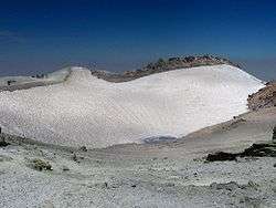
Mount Damavand first erupted in the Pleistocene almost 1.78 million years ago. After several known eruptions around 600,000 and 280,000 years ago, it finally erupted about 7300 years ago in the Holocene. Its steep cone is formed of ash and lava flows that are mainly made of trachyte, andesite and basalt. The Quaternary lavas are directly located on the Jurassic sediments.[11] The volcano is crowned by a small crater with sulfuric deposits. There are also fumaroles, hot springs, and mineral deposits of travertine. Mount Damavand could be considered as a potentially active volcano,[12] because there are fumaroles near the summit crater emitting sulfur, which were known to be active on July 6, 2007.[13]
Thermal springs
Mineral hot springs are mainly located on the volcano's flanks and at the base, giving evidence of volcanic heat comparatively near the surface of the earth. While no historic eruptions have been recorded, hot springs at the base and on the flanks, and fumaroles and solfatara near the summit, indicate a hot or cooling magma body still present beneath the volcano.
The most important of these hot springs are located in Abe Garm Larijan in a village by the name Larijan in the district of Larijan in Lar Valley. The water from this spring is useful in the treatment of chronic wounds and skin diseases. Near these springs there are public baths with small pools for public use.
Routes to the summit
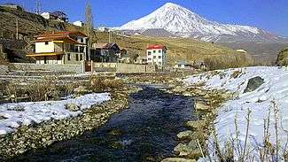
The best major settlement for mountain climbers is the new Iranian Mountain Federation Camp in the village of Polour, located on the south of the mountain.
There are at least 16 known routes[14] to the summit, with varying levels of difficulty. Some of them are very dangerous and require rock climbing. The most popular route is the Southern Route which has step stamps and a camp midway called Bargah Sevom Camp/Shelter[15] at 4220 m (about 13,845 ft). The longest route is the Northeastern and it takes two whole days to reach the summit starting from downhill village of Nāndal and a night stay at Takht-e Fereydoun (elevation 4300 m - about 13,000 ft), a two-story shelter. The western route is famous for its sunset view. Sīmorgh shelter in this route at 4100 m (about 13,500 ft) is a newly constructed shelter with two stories. There is a frozen waterfall/Icefall[16] (Persian name Ābshār Yakhī) about 12 m tall and the elevation of 5100 m is the highest fall in Iran and Middle East.
Geographical location
| Map of central Alborz | Peaks: | 1 `Alam Kūh |
|---|---|---|
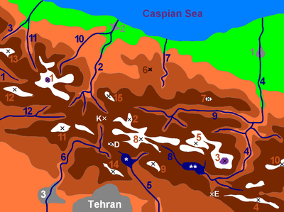 -25 to 500 m 500 to 1500 m 1500 to 2500 m 2500 to 3500 m 3500 to 4500 m 4500 to 5671 m |
2 Āzād Kūh | 3 Damāvand |
| 4 Do Berar | 5 Do Khaharan | |
| 6 Ghal`eh Gardan | 7 Gorg | |
| 8 Kholeno | 9 Mehr Chal | |
| 10 Mīšīneh Marg | 11 Naz | |
| 12 Shah Alborz | 13 Sīālān | |
| 14 Tochal | 15 Varavašt | |
| Rivers: | 0 | |
| 1 Alamūt | 2 Chālūs | |
| 3 Do Hezār | 4 Harāz | |
| 5 Jājrūd | 6 Karaj | |
| 7 Kojūr | 8 Lār | |
| 9 Nūr | 10 Sardāb | |
| 11 Seh Hazār | 12 Shāh Rūd | |
| Cities: | 1 Āmol | |
| 2 Chālūs | 3 Karaj | |
| Other: | D Dīzīn | |
| E Emāmzādeh Hāšem | K Kandovān Tunnel | |
| * Latīān Dam | ** Lār Dam |
Wildlife
Fish
Damavand rivers and slopes are famous for the beautiful Brown Trout (Salmo trutta),[17][18]
Mammals
Red Sheep (Ovis orientalis) and Wild Goats (Capra aegagrus) live in the region of Damavand Mts. Persian leopard (Panthera pardus saxicolor) and Syrian brown bear (Ursus arctos syriacus) live in this region. Some smaller mammals are the snow vole (Chionomys nivalis), mouse-like hamster (Calomyscus bailwardi) and Afghan pika (Ochoton rufescens).[19][20][21]
Birds
The very attractive and unreachable Caspian snowcock (Tetragallus caspius) lives at high altitudes. Golden eagle (Aquila chrysaetos) breeds in this area. Griffon vultures (Gyps fulvus) are common. Chukar partridge (Alectoris chukar) has a high population and nests between stone and shrubs. Red-fronted serin (Serinus pusillus), linnet (Carduelis cannabina), snow finch (Montifringilla nivalis), rock sparrow (Petronia petronia), rock bunting (Emberiza cia) and horned lark (Eremophila alpestris) are native; in winter they come to the lower hill sides. In each spring wheatear (Oenanthe oenanthe), rock thrush (Monticola saxatilis), and nightingale (Luscinia megarhynchos) come from Africa for breeding. Grey-necked bunting (Emberiza buchanani), black-headed bunting (Emberiza melanocephala) and common rosefinch (Carpodacus erythrinus) come from India.[22]
Reptiles and amphibians
Lots of marsh frogs (Rana ridibunda) live in Lar riversides. Meadow viper (Vipera ursinii), blunt-nosed viper (Macrovipera lebetina), Iranian valley viper (Vipera latifii) and Caucasian agama (Laudakia caucasia) are among the reptiles of this mountainous region.[23][24]
Flora
On the southern slope of Damavand, there are remnants of Wild Pistachia Trees (Pistacia atlantica) ; In its riversides different kinds of Salix trees like Willow (Salix acomphylla) and Oleaster (Elaeagnus angustifolia) are found. Greek Juniper (Juniperus excelsa) is common all over the higher altitudes. On Northern slopes, because of higher humidity, there are wild oak, beech and hazel trees like: Persian Oak (Quercus macranthera), Eastern Hornbean (Carpinus orientalis), and Oriental beech (Fagus orientalis).[25] There are also many beautiful wild flowers like: Mountain Tulip (Tulipa montana) and Stone cress (Aethionema grandiflorum). At higher altitudes, shrubs tend to be sphere and cushion like, examples are : Astragalus species (like Astragalus microcephalus), Mountain Sainfoin (Onobrychis cornuta) and Prickly (Acantholimon erinaceum) ; Different kinds of grasses between them complete this alpine scene .[26] Iris barnumiae subsp. demawendica (formerly Iris demawendica), is found and named after the mountain.[27][28]
Nomination as National Heritage Site
An anthropologist of Mazandaran Cultural Heritage and Tourism Department, Touba Osanlou, has said that a proposal has been made by a group of Iranian mountaineers to register the highest peak in the Middle East, Mount Damavand as a national heritage site. Mazandaran Cultural Heritage and Tourism Department has accepted the proposal, the Persian daily Jam-e Jam reported. Osanlou noted that the Iranian Cultural Heritage and Tourism Organization is presently in the process of renaming an upcoming ancient festivity after Mount Damavand. "We have proposed Tirgan Festivity, Tabari Nowruz, to be named as Damavand National Day," he added. Tirgan Festivity is held in Amol County's Rineh region in Mazandaran province.[29]
See also
- List of mountains in Iran
- List of volcanoes in Iran
- Lists of volcanoes
- Volcanic Seven Summits
- List of Ultras of West Asia
- List of peaks by prominence
References
- ↑ Geography of Iran
- 1 2 "Kuh-e Damavand" - Iran Ultra Prominence peaklist.org. Retrieved 16 October 2011
- ↑ U.S. military topographic mapping gives 18,365 feet (5,598 meters). A summitpost map based on local 1:50,000 mapping gives 5,628 metres. This is supported by GPS evidence and SRTM data.
- 1 2 "Damavand, Iran". Peakbagger.com.
- ↑ Pona, Georgia - Key col for Damavand peakbagger.com. Retrieved 29 January 2016
- ↑ "SummitPost: Damavand". Retrieved 2010-04-28.
- ↑ "Mountain Damavand". PersiaPort. Retrieved 19 June 2015.
- ↑ "Damavand Volcano". volcanodiscovery.com. Retrieved 19 June 2015.
- ↑ Microsoft Encarta World Atlas, 2001, Microsoft Corporation
- ↑ Central Bank of Iran. Banknotes & Coins: 10000 Rials. – Retrieved on 24 March 2009.
- ↑ Geological Map of Iran, National Geoscience Database of Iran, www.ngdir.ir
- ↑ "Damavand". Global Volcanism Program. Smithsonian Institution.
- ↑ "Volcanic Hole on Damavand". Retrieved 2007-08-23.
- ↑
- ↑
- ↑
- ↑ Mohammadian, H. Freshwater Fishes of Iran. Sepehr Publishing Center. Iran. 2000.
- ↑ Yazdani, A. Lar the Paradise I Knew. Payam Resan Publishing Institute. 2010.
- ↑ Lay, D.M. A Study of the Mammals of Iran ( Resulting From the Street Expedition ). Field Museum of Natural History. Chicago .1967.
- ↑ Mohammadian, H. The Life of Alborz Red Sheep. Shabpareh Publishing Institute. 2008. ISBN 978-600-5038-00-2.
- ↑ Mohammadian, H. Mammals of Iran. Shabpareh Publishing Institute. 2005. ISBN 964-94487-9-9.
- ↑ Mohammadian, H. Mountain birds of Tehran. Shabpareh Publishing Institute. 2008. ISBN 964-96358-9-0.
- ↑ Shahbazi, Y. Lar National Park Management Program. Natural Environment Department Library. 2004.
- ↑ Mohammadian, H. Reptiles and Amphibians of Iran. Shabpareh Publishing Institute. 2004. ISBN 964-94487-2-1.
- ↑ Mozaffarian, V. Trees and Shrubs of Iran. Farhang Moaser Publishers. 2005. ISBN 964-8637-03-2.
- ↑ Mozaffarian, V. Lar National Park Management Program. Natural Environment Department Library. 2004.
- ↑ Richard Lynch The Book of the Iris (1904), p. 115, at Google Books
- ↑ Wallis, Dr; Wallis, Mrs. "Newsletter October 2009, Iran Caspian to Kopet Dag" (PDF). agscentralsussex.plus.com (The Alpine Garden Society). Retrieved 7 June 2016.
- ↑
External links
| Wikimedia Commons has media related to: |
- U.S. Geological Survey
- CIA: The World Factbook
- "Damavand". Global Volcanism Program. Smithsonian Institution.