Shasta Lake
| Shasta Lake | |
|---|---|
 | |
| Location |
Shasta-Trinity National Forest Shasta County, California |
| Coordinates | 40°45′37″N 122°22′19″W / 40.7602°N 122.37190°WCoordinates: 40°45′37″N 122°22′19″W / 40.7602°N 122.37190°W |
| Type | Reservoir |
| Primary inflows | Sacramento River, Pit River, McCloud River |
| Primary outflows | Sacramento River |
| Basin countries | United States |
| Max. length | 35 mi (56 km) |
| Surface area | 30,000 acres (12,000 ha) |
| Max. depth | 517 ft (158 m) |
| Water volume | 4,552,000 acre·ft (5.615 km3) |
| Shore length1 | 365 mi (587 km) |
| Surface elevation | 1,067 ft (325 m) |
| Settlements | Lakehead |
| References | U.S. Geological Survey Geographic Names Information System: Lake Shasta |
| 1 Shore length is not a well-defined measure. | |
Shasta Lake is a reservoir in Shasta County, California, United States. It is within the Whiskeytown–Shasta–Trinity National Recreation Area, operated by the Shasta-Trinity National Forest. It is also popularly known as "Lake Shasta".[1]
It is impounded by Shasta Dam, the ninth tallest dam in the United States.[2] Known as the keystone of the Central Valley Project, the outflow of Shasta Dam provides electricity and irrigation water. It also provides Sacramento River flood control below the dam for the Sacramento Valley.
Geography
With a capacity of 4,552,000 acre·ft (5,615,000 dam3) at full pool, the lake has an elevation of 1,067 ft (325 m), and a surface area of 30,000 acres (12,000 ha), making it the state's largest reservoir, and its third-largest body of water after Lake Tahoe and the Salton Sea.
Ten miles (16 km) north of the city of Redding, with the town of Lakehead on its northern shore, Shasta Lake is popular for boating, water skiing, camping, house boating and fishing. Formed by the damming of the Sacramento River, the lake has 365 mi (587 km) of mostly steep mountainous shoreline covered with tall evergreen trees and manzanita. The maximum depth is 517 feet (158 m).
The lake has four major arms, each created by an approaching river: The Sacramento River, the McCloud River, Squaw Creek, and the Pit River. The Sacramento River's source is the Klamath Mountains. The McCloud River's source is Mt. Shasta. The Pit River flows from Alturas.
History
Shasta Dam was constructed between 1935 and 1945 across the Sacramento River, and Shasta Lake was formed in 1948. The Pit River, McCloud River, and several smaller tributaries had their lower courses and confluences with the Sacramento River submerged by the reservoir. Also beneath the lake is the submerged town of Kennett and many village sites of the Wintun people together with their traditional fishing, hunting, and gathering locations. Parts of the defunct tunnels and right of way of the Southern Pacific Transportation Company can be seen when the water level is low.
Shasta Lake hosted the first "Boardstock" event in 1996, which continued there annually through 1999, after which the annual event moved to Clear Lake, California, 170 miles southwest of Shasta Lake. Boardstock drew many pro wakeboard riders from around the world, with an average attendance of 15,000 people. The event lasted for 3 days each year with several wakeboard contests being performed.
Marinas
Bridge Bay at Shasta Lake: The largest marina (over 700 slips) on Shasta Lake. This property boasts the CookHouse restaurant, the BarRoom, a 40-room Lodge, retail and other facilities. Visitors to Bridge Bay may rent one of 100 Houseboats, as well as ski boats, fishing boats, patio boats, and all types of personal water craft such as StandUp Paddle Boards, Waverunners, and the occasional water thrill such as the Jetovator. Bridge Bay boasts a busy public dock during the summer season, with a gas dock, food, ice and retail amenities.
Digger Bay Marina: Digger Bay has over 150 boat slips in the marina, as well as a retail store and small boat rental. Digger Bay is located almost 10 miles from Highway 5, and is a secluded marina retreat on Shasta lake.
Shasta Marina Resort: Houseboat Rentals / Located at the center of the Sacramento Arm of Lake in the O'Brien Inlet/ Interstate 5 O'Brien Exit #695 Lakehead, CA
Packer's Bay Marina: Located at the center of the lake, just north of Bridge Bay Marina.
Antler's Marina: Shasta's north most marina.
Silverthorn Marina: Located on the East part of the lake, Silverthorn offers large houseboats for rent.
Jones Valley Resort: As the east most marina on the lake, Jones Valley is tucked far into a cove, and features six different model rental houseboats, including the largest on the lake, the Titan.
Holiday Harbor: Located up the McCloud River Arm, east of I-5.
Sugarloaf Marina: Located up the Sacramento River Arm. Marina store, overnight slips, and fuel offered.
Climate
Shasta Lake has a Temperate climate
| Climate data for Shasta Lake | |||||||||||||
|---|---|---|---|---|---|---|---|---|---|---|---|---|---|
| Month | Jan | Feb | Mar | Apr | May | Jun | Jul | Aug | Sep | Oct | Nov | Dec | Year |
| Record high °F | 65 | 71 | 76 | 82 | 87 | 92 | 104 | 108 | 101 | 95 | 83 | 72 | 108 |
| Record low °F | 36 | 41 | 47 | 53 | 57 | 62 | 65 | 68 | 65 | 63 | 54 | 47 | 36 |
| Record high °C | 18 | 22 | 24 | 28 | 31 | 33 | 40 | 42 | 38 | 35 | 28 | 22 | 42 |
| Record low °C | 2 | 5 | 8 | 12 | 14 | 17 | 18 | 20 | 18 | 17 | 12 | 8 | 2 |
Gallery
 Lake Shasta from I-5
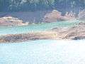
 Low waters on Lake Shasta
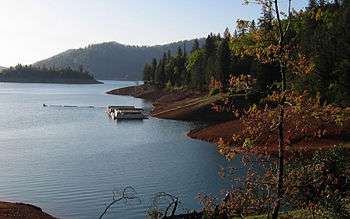 Lake from the shoreline
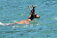 Deer swimming in Lake Shasta
 Shasta Lake and Shasta Dam
See also
- Shasta Unit — of the Whiskeytown–Shasta–Trinity National Recreation Area.
- List of dams and reservoirs in California
- List of largest reservoirs of California
- List of lakes in California
References
- ↑ "Lake Shasta"; "Lake Shasta"; "Lake Shasta"; "Lake Shasta";
- ↑ "USSD Dam, Hydropower and Reservoir Statistics". United States Society on Dams. Retrieved 2014-11-29.
- Department of Water Resources (2009). "Station Meta Data: Shasta Dam (SHA)". California Data Exchange Center. State of California. Retrieved 2009-04-01.
- "Shasta Lake Facts, Statistics and Data". ShastaLake.com. 22 September 2009. Retrieved 2009-09-17.
External links
External links
| Wikimedia Commons has media related to Shasta Lake. |