King Historic District
|
King Historic District | |
|
King Drug Company, King Historic District, September 2013 | |
  | |
| Location | Dalton Rd., Main St., School St. and Railroad Right of Way, King, North Carolina |
|---|---|
| Coordinates | 36°24′30″N 80°12′24″W / 36.40833°N 80.20667°WCoordinates: 36°24′30″N 80°12′24″W / 36.40833°N 80.20667°W |
| Area | 25 acres (10 ha) |
| Built | 1939 |
| Architectural style | Colonial Revival, Bungalow/craftsman |
| NRHP Reference # | 02000941[1] |
| Added to NRHP | September 6, 2002 |
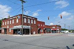
King Historic District is a national historic district located at King, Stokes County, North Carolina. The district encompasses 72 contributing buildings and 1 contributing structure in the central business district and surrounding residential sections of King. They were built between about 1914 to the 1950s and include notable examples of Colonial Revival and Bungalow / American Craftsman architecture. Notable buildings include the Bank of King, King Drug Company, Simeon Wesley Pulliam House (c. 1907), James Robert Hutchins House (c. 1905), King Milling Company (c. 1920), and King Moravian Church (c. 1925).[2]
It was added to the National Register of Historic Places in 2002.[1]
References
- 1 2 National Park Service (2010-07-09). "National Register Information System". National Register of Historic Places. National Park Service.
- ↑ Sherry Joines Wyatt and Sarah A. Woodard (November 2001). "King Historic District" (pdf). National Register of Historic Places - Nomination and Inventory. North Carolina State Historic Preservation Office. Retrieved 2015-05-01.


This article is issued from Wikipedia - version of the 12/1/2016. The text is available under the Creative Commons Attribution/Share Alike but additional terms may apply for the media files.