Khunti district
| Khunti district खूंटी जिला | |
|---|---|
| District of Jharkhand | |
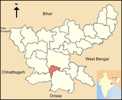 Location of Khunti district in Jharkhand | |
| Country | India |
| State | Jharkhand |
| Administrative division | South Chotanagpur division |
| Headquarters | Khunti |
| Government | |
| • Lok Sabha constituencies | Khunti (shared with Simdega, Ranchi and Seraikela Kharsawan districts) |
| • Assembly seats | 3 |
| Area | |
| • Total | 2,611 km2 (1,008 sq mi) |
| Population (2011) | |
| • Total | 530,299 |
| • Density | 200/km2 (530/sq mi) |
| Demographics | |
| • Literacy | 64.51 per cent |
| • Sex ratio | 994 |
| Website | Official website |
Khunti district (Hindi: खूंटी जिला) is one of the twenty-four districts in South Chotanagpur division of the Indian state of Jharkhand. The district of Khunti was carved out of Ranchi district on 12 September 2007. As of 2011, it is the second least populous district of Jharkhand (out of 24), after Lohardaga.[1] Khunti town is the headquarters of the district.
It is historically known as the birthplace of Birsa Munda, and being the centre of activity of the Birsa movement.[2][3]
The district is currently a part of the Red Corridor.[4]
Popular Places
- Panchgagh Fall ( Water fall )
One of the most unusual waterfalls of Khunti, Panchghagh has 5 streams to it. The Banai River branches itself out in five different streams, generating ubiquitous singing rivulets through the cluster of rocks.Natural beauty around the waterfall makes it more beautiful and peaceful.
- Anganbari –Shiv Temple
It is famous religious center of the district known for its Shiv Temple. Every year during Sawan season local festival is celebrate for one month long. On Maha-shivratri Day, temple is visited by many disciples from different regions of Jharkhand. It is located on Khunti-Torpa road 9 km from the district headquarters.
- Dombari Buru
It is picturesque hills of Dombari Buru, which had turned red with blood when BirsaMunda led his legendary ulgulan(rebellion) against the British more than a century ago, will now get a sterling facelift, courtesy. Archaeological Survey of India (ASI). It is located 50 km from the state capital, Dombari Buru rises determinedly above Sail Rakab village close to Ulihatu — the birthplace of the tribal icon
Administration
Blocks/Mandals
Khunti district has six community development blocks. The following are the list of the Blocks in Khunti district:
Karra block is situated nearly 30 km from Dhurwa and 18 km from Khunti. Sai Baba mandir is at Sai Gram. Karra is known for its ancient linkage with Uttar Pradesh when merchants came from Gazipur to settle. Neighborhoods (tola) include Nawkel, Dakghar, Baraiktoli, Station, Mahto toli, Masmano and Karra Chawk. Aamreshwar Dham, also known as Angrabari, hosts many temples, mostly for Lord Shiva. Aamreshwar Dham gathers devotees in Savan month of Hindu calendar, as the sacred month of Lord Shiva. Other temples include Durga Ghar and Devi guri in Mahato toli; Dakghar Shiva temple, Nawkel Devi guri temple (made by Sri Janki Sahu). Karra has two Churches and two Mosques. Work has shifted from agriculture to export of local goods such Mahua, Tamarind, Madua(ragi) and Dhan(paddy). to wholesale markets in Ranchi and Lakhanow. Majority of people are Munda, Oraon and Christians converted Mundas. Other people are Baraik, Rajput (Ganjhu), Bania, Halwai, Brahmins, Dhobi, Chamar, Nai, Muslims, etc. Karra is known for sweet potatoes.
Demographics
According to the 2011 census Khunti district has a population of 530,299,[1] roughly equal to the nation of Cape Verde.[5] This gives it a ranking of 541st in India (out of a total of 640).[1] The district has a population density of 215 inhabitants per square kilometre (560/sq mi) .[1] Its population growth rate over the decade 2001-2011 was 21.96%.[1] Khunti has a sex ratio of 994 females for every 1000 males,[1] and a literacy rate of 64.51%.[1]
References
- 1 2 3 4 5 6 7 "District Census 2011". Census2011.co.in. 2011. Retrieved 2011-09-30.
- ↑ Birsa Mumda commemorative postage stamp and biography India Post, 15 November 1988.
- ↑ "Jharkhand Police". Retrieved 2009-03-10.
- ↑ "83 districts under the Security Related Expenditure Scheme". IntelliBriefs. 2009-12-11. Retrieved 2011-09-17.
- ↑ US Directorate of Intelligence. "Country Comparison:Population". Retrieved 2011-10-01.
Cape Verde 516,100 July 2011 est.
External links
Coordinates: 23°04′12″N 85°16′48″E / 23.07000°N 85.28000°E