Gumla
| Gumla गुमला | |
|---|---|
| city | |
 Gumla  Gumla Location in Jharkhand, India | |
| Coordinates: 23°00′N 84°30′E / 23°N 84.50°ECoordinates: 23°00′N 84°30′E / 23°N 84.50°E | |
| Country |
|
| State | Jharkhand |
| District | Gumla |
| Population (2001) | |
| • Total | 104,600 |
| • Density | 197/km2 (510/sq mi) |
| Languages | |
| • Official | Hindi, English |
| • Other important | urdu |
| Time zone | IST (UTC+5:30) |
| PIN | 835207 |
| Telephone code | 06524 |
| Vehicle registration | JH 07 |
| Website |
www |
Gumla (Hindi: गुमला) is a city which is the headquarters of Gumla district in the state of Jharkhand, India.
History
Gumla began as a hamlet. A week-long "Cow Fair" (Gau-Mela) took place every year, where items in daily use (utensils, ornaments, grain and sometimes cattle) were sold or bartered. Since these items were only available at the fair, people would keep lists during the year of what they needed. The hamlet's population grew, and it became a village named "Gumla" (a derivative of Gau–Mela).
During British rule in India Gumla was in Lohardaga district, and in 1800 there was a revolt against the Raj. In 1807 the Oraons of Barway (west of Gumla) murdered their landlord from Srinagar, and the uprising spread throughout Gumla. In 1843, Gumla became part of Bishunpur province. The province, which was abolished in 1899, was later named Ranchi; in 1902, Gumla became a subdivision of Ranchi district.
During the medieval era, the Chhotanagpur region was ruled by the kings of the Naga dynasty and Baraik Devenandan Singh ruled the Gumla region. During the Kolh Reble in 1931–32, Vaktar Say reportedly played a prominent role. Ganga Maharaj, who built the Kali Temple at Sri Ramnagar, was active in the Quit India Movement in 1942; for his contribution to Indian independence, he received a pension from the government.
On May 18, 1984, Gumla District was established by Bihar Chief Minister Jagannath Mishra. Dwarika Nath Sinha was appointed the first deputy commissioner of the new district.
Geography
Gumla is in the southern part of the Chota Nagpur Plateau, which forms the eastern edge of the Deccan Plateau. Three rivers flow through the area: the South Koyel, the North Koyel and the Shankh.
Climate
Gumla has a temperate, sub-tropical climate, with an average high of 40 °C (104 °F) in summer and an average low of 3 °C (37 °F) in winter. Average annual rainfall is about 1,450 millimetres (57 inches).
Demographics
As of 2001[1] Gumla had a population of 104,600, with males constituting 52 percent and females 48 percent. Gumla had an average literacy rate of 75 percent, higher than the national average of 59.5 percent: male literacy was 80 percent, and female literacy 70 percent. Fifteen percent of the population was under six years of age. Major languages spoken in the region are Nagpuri (or Sadri), Hindi, Oriya, Bihari and Kurukh.
Connectivity
a) Roadways
Gumla is connected to Ranchi and Simdega via NH – 23. It is connected via State Highways to Lohardaga, Latehar, Daltonganj and other major towns of the State.
It is connected to the State of Chhattisgarh via NH - 78.
Union Minister of Road Transport, Highways and Shipping, Nitin Gadkari will soon lay the foundation of the much awaited Gumla bypass project. A total 12.6 km long road shall connect Silam village on NH-78 under Raidih block to Dhodhra village in Gumla block on NH - 23.
b) Railways
Pokla is the only Indian Railways station in the District of Jharkhand, the other stations in proximity being Bano, Govindpur Road, Tori, Latehar, Orga and Mccluskieganj.
Education
In 1986 Rakesh Popli and his wife, Rama (an expert in childhood education), founded the first Ekal Vidyalaya (one-teacher) schools to bring education to the tribes of the region.[2] Students go to Ranchi for higher education. Ranchi University has three colleges:
- Kartik Oraon College
- Women’s College
- Karunavati Devi Memorial College
Schools in Gumla include:
- Saraswati Shishu-Vidya Mandir
- Adarsh Vidya Mandir School, Pugu
- Don Bosco School, Bhamni
- St. Ignatius School
- Oxford Public School
- Natro Dame School
- D.A.V. Public School
- St. Stephen’s School
- Ursuline Convent School
- S.S. High School
- St. Patrick School
- Wescott Public School
St. Ignatius School, founded in 1935 and administered by the Jesuits, has produced international-level hockey players.
Tourist attractions
- Anjan – A small village about 18 kilometres (11 mi) from Gumla. Its name derives from the goddess Anjani, mother of Hanuman (who was born here. Objects of archaeological importance obtained from the village have been placed in the Patna Museum.
- Baghmunda – Known for its religious stone idols
- Nagar - In Sisai block, it has a fort belonging to the Nagbansi kings.
- Rajendra – Known for its hilly, scenic beauty
- Dewaki – Known for a Shiv-Parvati temple. During the month of Sawan, devotees visit to offer water to the Shiva Linga
- Basudeokona – Known for its religious stone idols, it is 3 kilometres (1.9 mi) east of Raidih block.
- Taraloya has a waterfall locally known as "Perwahatt", and is 30 kilometres (19 mi) south of Raidih block.
- Hapamuni – Known for an ancient Mahamaya temple.
- Palkot[3]
- Nagfeni – Famous for its Jagannath temple and a large stone in the shape of the snake Nag.
- Tanginath[4]
- Birsa Munda Agro Park
- Raidih – Raidih block, one of the district's eleven administrative blocks, is known for its scenic beauty.
Festivals and dances
The Karma festival rotates from village to village. It is divided into three parts: Raj karma, Budhui karma and Padda karma. Raj karma is celebrated by the entire community; Budhi karma is celebrated by old women in June to summon the rain god. Padda karma is celebrated by the entire village.
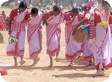
Sarhul, an Oraon festival, is known for its dance. Dancers form a circle, with musicians playing traditional instruments inside it. Men wear a white dhoti with a red border and women wear a white sari with a red border. In the bheja dance, dozens of young boys and girls form a chain by clasping hands. The dance has a variety of postures, with melodious traditional music and rhythmic songs.
Clubs
- Rotary Club of Gumla
- Sarna Club
- Nav Yuvak Sangh
- Inner Wheel Club
- Novel Club[5]
See also
References
- ↑ "Census of India 2001: Data from the 2001 Census, including cities, villages and towns (Provisional)". Census Commission of India. Archived from the original on 2004-06-16. Retrieved 2008-11-01.
- ↑ "Dr. Rakesh Popli, Nuclear Scientist & one of Ekal's Visionaries, passed away on September 15, 2007". Newsletter October 2007. Ekal Vidyalaya Foundation. Retrieved 22 March 2012.
- ↑ "Palokot". The Official Website of Gumla. Archived from the original on 16 April 2009. Retrieved September 15, 2015.
- ↑ "Tanginath". The Official Website of Gumla. Archived from the original on 16 April 2009. Retrieved September 15, 2015.
- ↑ https://www.facebook.com/novelclubgumla/