Keta
| Keta | |
|---|---|
| Town & Municipality Capital | |
|
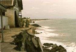
Fort Prinsensten on the beach of Keta in 1985 | |
 Keta Location of Keta in Volta | |
| Coordinates: 5°55′N 0°59′E / 5.917°N 0.983°E | |
| Country |
|
| Region |
|
| District | Keta Municipal District |
| Population (2013) | |
| • Total | 23,207[1] |
| • Density | 1,829/sq mi (706/km2) |
| Ranked 61st in Ghana | |
| Time zone | GMT |
| • Summer (DST) | GMT (UTC) |
| Area code(s) | +233 (3626) |
Keta is a town in the Volta Region of Ghana. It is the capital of the Keta Municipal District.[2]
Keta is the sixty-first most populous settlement in Ghana in terms of population, with a population of 23,207.[1] Parts of the town were devastated by sea erosion between the 1960s and 1980s. Keta is mentioned in Maya Angelou's All God's Children Need Traveling Shoes.
History
Keta was settled by the Anlo Ewe, a sub-group of the Ewe people who, in the 17th century, migrated to the area from Ketu, in Benin.[3]
Keta was an important trading post between the 14th and the late 20th centuries. The town attracted the interest of the Danish, because they felt they could establish a base here without interference from rival European nations. Their first initiative was to place a factor at Keta to sell alcohol.[4]
In 1792, a war between Anloga and Keta broke out.
Faced with the threat of war between Peki and an alliance of the Ashanti and the Akwamu, the North German Missionary Society (also known as the Bremen Missionaries) moved the focus of their activities from Peki to Keta. Their missionaries, Dauble and Plessing, landed at nearby Dzelukofe on September 2, 1853.[5]
Historically Keta was also known as Quittah and was assigned B27 as a postal mark.[6]
From 1874 Hausa Constabulary were based at Keta, and soon there grew to be a community of Hausa traders in the town.[4]
Ecology
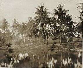
In 1784, Fort Prinzenstein, like most slave trade forts, was built by the sea's edge. However the sea had retreated by about 600 ft by 1907. Since then Keta has been subject to sustained erosion. The Bremen Factory and Coconut plantation, which were close to the high water mark in 1907, had been swept away by the sea by 1924. The erosion has now advanced as far as Queen Street and started to wear away the Fort.[4]
Close to Keta is the famous town of Woe, known for the notable lighthouse called Cape St. Paul Lighthouse[7] on the beach that is believed to guide ships away from a mythical massive underwater mountain. This lighthouse is also thought to be the oldest in Ghana.[8]
Keta Lagoon
Keta Lagoon is the largest lagoon in Ghana with a water area of 300 km2. This is located in a larger wetlands protected area of 1200 km2. It is a stopping point for a large number of migratory birds and provides a breeding ground for sea turtles.[9]
See also
References
- 1 2 "World Gazetteer online". World-gazetteer.com.
- ↑ Touring Ghana - Volta Region. touringghana.com.
- 1 2 3 Akyeampong, Emmanuel Kwaku (2001). Between the Sea and the Lagoon. Oxford: James Currey. p. 46. ISBN 0-85255-776-0.
- ↑ Agbeti, J Kofi (1986). West African Church History: Christian Missions and Church Foundations 1482-1919. Leiden: Brill Archive.
- ↑ "British Commonwealth Postmarks". Philatelic Bibliopole. Retrieved 2 April 2014.
- ↑ "about this municipality". ghanadistricts.gov.gh. Retrieved 19 January 2014.
- ↑ Briggs, Philip (2010). Ghana. Bradt Travel Guides. p. 234.
- ↑ "Keta Lagoon Complex Ramsar Site". Retrieved 5 April 2014.
District capitals in Ghana | |
|---|---|
| Ashanti Region | |
| Brong-Ahafo Region | |
| Central Region | |
| Eastern Region | |
| Greater Accra Region | |
| Northern Region | |
| Upper East Region | |
| Upper West Region | |
| Volta Region | |
| Western Region | |
Regional capitals in bold
| |