Island Lake, Algoma District
For the settlement of the same name in Sudbury District, see Island Lake, Sudbury District.
| Island Lake | |
| Settlement | |
 | |
| Country | Canada |
|---|---|
| Province | Ontario |
| Region | Northeastern Ontario |
| District | Algoma |
| Municipality | Algoma, Unorganized, North Part |
| Elevation | 334 m (1,096 ft) |
| Coordinates | 46°40′41″N 84°15′51″W / 46.67806°N 84.26417°WCoordinates: 46°40′41″N 84°15′51″W / 46.67806°N 84.26417°W |
| Timezone | Eastern Time Zone (UTC-5) |
| - summer (DST) | Eastern Time Zone (UTC-4) |
| FSA | P0S |
| Area code | 705 |
 Location of Island Lake in Ontario | |
Island Lake is a settlement in the Unorganized North Part of Algoma District in northeastern Ontario, Canada. It is part of the Aweres local services board and is about 5 kilometres (3 mi) northeast of the community of Heyden on Ontario Highway 17. The settlement is at the junction of Ontario Highway 552 and Ontario Highway 556, and the Algoma Central Railway passes through the community.
Island Lake lies on the shores of Upper Island Lake and Lower Island Lake; the Upper Island Lake Dam controls the flow from the former to the latter, and the waters flow via the Root River to the St. Marys River.
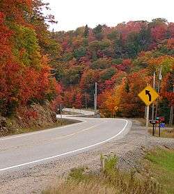
Highway 556 at Island Lake
References
- "Island Lake". Geographical Names Data Base. Natural Resources Canada. Retrieved 2010-07-24.
- "Topographic Map sheet 41K9". Atlas of Canada. Natural Resources Canada. 2010-02-04. Retrieved 2010-07-24.
| Cities | 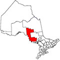 | |
|---|---|---|
| Towns | ||
| Townships | ||
| Villages | ||
| First Nations | ||
| Indian reserves | ||
| Local services boards | ||
| Unorganized areas | ||
| ||
This article is issued from Wikipedia - version of the 10/14/2013. The text is available under the Creative Commons Attribution/Share Alike but additional terms may apply for the media files.