Jocelyn, Ontario
| Jocelyn | |
|---|---|
| Township (single-tier) | |
| Township of Jocelyn | |
|
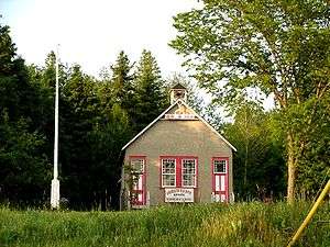
Municipal building | |
 Jocelyn | |
| Coordinates: 46°11′N 83°58′W / 46.183°N 83.967°WCoordinates: 46°11′N 83°58′W / 46.183°N 83.967°W | |
| Country |
|
| Province |
|
| District | Algoma |
| Government | |
| • Type | Township |
| • Reeve | Mark Henderson |
| • Governing Body | Jocelyn Township Council |
| • MP | Bryan Hayes (CPC) |
| • MPP | Michael Mantha (NDP) |
| Area[1] | |
| • Total | 131.37 km2 (50.72 sq mi) |
| Population (2011)[1] | |
| • Total | 237 |
| • Density | 1.8/km2 (5/sq mi) |
| Time zone | EST (UTC-5) |
| • Summer (DST) | EDT (UTC-4) |
| Postal code | P0R 1G0 |
| Area code(s) | 705 |
| Website | jocelyntownship.com |

Jocelyn is a township in the Canadian province of Ontario, located on St. Joseph Island in the Algoma District. The current reeve of the township is Mark Henderson. Jocelyn is home to Fort St. Joseph National Historic Site.
The primary community in the township is Kentvale, which is located around Kentvale Merchants Limited, the largest general store on St. Joseph Island. Kentvale Merchants Limited is actually located in the Township of St. Joseph and previously operated under the name Kentvale General Merchants. It was opened in 1888 by Emily M. Kent and Frederick B. Kent. A community outdoor hockey rink on the property provided recreation for this farming community for many years. It was operated by the Kent family and volunteers from the community.
The original operation consisted of a grist and saw mill operated by Frederick and a store that Emily ran. At the time of this writing in 2005, the fourth generation of the original owners are operating the store. Today the store sells groceries, hardware, dry goods, building supplies, lawn and garden equipment, gasoline, fishing gear, feed for livestock and much more.
Demographics
The township had a population of 237 in the Canada 2011 Census, down from 277 in the 2006 census.
| Canada census – Jocelyn, Ontario community profile | |||
|---|---|---|---|
| 2011 | 2006 | 2001 | |
| Population: | 237 (-14.4% from 2006) | 277 (-7.0% from 2001) | 298 (1.4% from 1996) |
| Land area: | 131.37 km2 (50.72 sq mi) | 131.37 km2 (50.72 sq mi) | 132.53 km2 (51.17 sq mi) |
| Population density: | 1.8/km2 (4.7/sq mi) | 2.1/km2 (5.4/sq mi) | 2.2/km2 (5.7/sq mi) |
| Median age: | 54.9 (M: 56.2, F: 54.4) | 49.7 (M: 51.5, F: 48.5) | |
| Total private dwellings: | 309 | 346 | 373 |
| Median household income: | $44,081 | $48,782 | |
| References: 2011[2] 2006[3] 2001[4] | |||
See also
References
- 1 2 "Jocelyn census profile". 2011 Census of Population. Statistics Canada. Retrieved 2012-02-17.
- ↑ "2011 Community Profiles". Canada 2011 Census. Statistics Canada. July 5, 2013. Retrieved 2012-02-17.
- ↑ "2006 Community Profiles". Canada 2006 Census. Statistics Canada. March 30, 2011. Retrieved 2012-02-17.
- ↑ "2001 Community Profiles". Canada 2001 Census. Statistics Canada. February 17, 2012. Retrieved 2012-02-17.
External links
| Wikimedia Commons has media related to Jocelyn, Ontario. |
 |
St. Joseph Township | | ||
| |
|
Hilton | ||
| ||||
| | ||||
| Potagannissing Bay |
Potagannissing Bay |
| Cities | 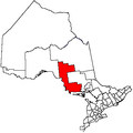 | |
|---|---|---|
| Towns | ||
| Townships | ||
| Villages | ||
| First Nations | ||
| Indian reserves | ||
| Local services boards | ||
| Unorganized areas | ||
| ||