New Jersey Route 495
| ||||
|---|---|---|---|---|
| Lincoln Tunnel Approach | ||||
 | ||||
| Route information | ||||
| Maintained by NJTA, NJDOT, PANYNJ | ||||
| Length: | 3.45 mi[1] (5.55 km) | |||
| Existed: | 1959 (1937 as Route 3) – present | |||
| Major junctions | ||||
| West end: |
| |||
|
| ||||
| East end: |
| |||
| Location | ||||
| Counties: | Hudson | |||
| Highway system | ||||
| ||||

Route 495 is a 3.45-mile (5.55 km) freeway in Hudson County, New Jersey in the United States that connects the New Jersey Turnpike (Interstate 95) at exits 16E and 17 in Secaucus to New York State Route 495 inside the Lincoln Tunnel in Weehawken, providing access to midtown Manhattan. The road is owned and operated by the New Jersey Turnpike Authority between the New Jersey Turnpike and Route 3, the New Jersey Department of Transportation between Route 3 and Park Avenue near the Union City/Weehawken border, and by the Port Authority of New York and New Jersey east of Park Avenue, including the helix used to descend the New Jersey Palisades to reach the entrance of the Lincoln Tunnel. Route 495 is mostly a six-lane freeway with a reversible bus lane used during the morning rush hour. The bus lane, which runs the entire length of the freeway, continues into the Lincoln Tunnel's center tube.
The first portion of the present-day Route 495, at the entrance to the Lincoln Tunnel, was constructed in 1937 when the Lincoln Tunnel opened. In 1939, it was extended west to Route 3 and it became an eastern extension of that route. In 1952, the portion of the route west of Route 3 was opened when the New Jersey Turnpike was completed. In 1959, the road was incorporated into the Interstate Highway System and was designated as part of Interstate 495. Since the Mid-Manhattan Expressway that would have connected the route to New York's Interstate 495 (Long Island Expressway) was canceled, Interstate 495 officially became New Jersey Route 495 in 1979, and the signs were changed in 1989.
Route description

Route 495 officially begins at the Exit 16E off-ramp of the northbound lanes of the New Jersey Turnpike near the boundary of Secaucus and North Bergen. The main roadway heads east through North Bergen as a freeway with three lanes in the eastbound and westbound directions, maintained by the New Jersey Turnpike Authority.[1][2] The route has an interchange with Route 3, with access to eastbound Route 3 and U.S. Route 1/9 for traffic in the eastbound direction and to westbound Route 3 in the westbound direction. Past this interchange, Route 495 becomes a six-lane freeway maintained by the New Jersey Department of Transportation that intersects U.S. Route 1/9 at a partial interchange, with a westbound exit and eastbound entrance. Past U.S. Route 1/9, the freeway has an interchange with County Route 501 (John F. Kennedy Boulevard), which uses 30th Street and 31st Street as collector/distributor roads.[1] East of this junction, Route 495 enters Union City and heads through developed residential areas, passing under numerous streets.[1][2] There is an eastbound exit and westbound entrance for Park Avenue, which provides access to Weehawken and Hoboken, where Route 495 becomes maintained by the Port Authority of New York and New Jersey. It enters Weehawken and comes to a westbound exit and eastbound entrance for Park Avenue.[1]

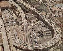
At this point, the roadway loops around itself at a section in the roadway locally known as The Helix, descending the New Jersey Palisades to reach the entrance to the Lincoln Tunnel under the Hudson River. The route has a westbound exit for County Route 677 (John F. Kennedy/Hudson Boulevard East) and another exit for Boulevard East with a westbound exit and eastbound entrance. After interchanging with Boulevard East, the road features an eastbound toll plaza and enters the Lincoln Tunnel. At the New York state line, which is located at the midpoint of the Hudson River, the road continues as New York State Route 495, which is separate from Interstate 495 (New York), and heads into midtown Manhattan in New York City.[1][2]
Since 1970, the left lane of the three westbound lanes is converted during the morning rush hour to a reversible bus lane, known as the "XBL", or Exclusive Bus Lane. The Port Authority of New York and New Jersey is responsible for daily operation of the XBL, including its opening and closing, removal of disabled vehicles, and response to emergencies.[3] It is used by buses headed east from the New Jersey Turnpike and Route 3, mainly to the Port Authority Bus Terminal just past the Lincoln Tunnel in Manhattan, serving over 1,800 buses and 65,000 bus commuters on regular weekday mornings, (6-10 a.m.).[4] This bus lane is the busiest in the United States.[5] Route 495 is a busy route that carries approximately 74,571 vehicles at its western terminus and approximately 119,432 vehicles by the time it reaches the Lincoln Tunnel.[1]
Each of the travel lanes in the Lincoln Tunnel's center tube is reversible. In general, both of the lanes, including one "XBL" (Exclusive Bus Lane), serve Manhattan-bound traffic during the weekday morning rush hour, both of the lanes serve New Jersey-bound traffic during the weekday evening rush hour, and one lane is provided in each direction during other time periods. New Jersey-bound traffic normally uses both lanes of the north tube and Manhattan-bound traffic normally uses both lanes of the south tube.
History
| |
|---|---|
| Location: | Secaucus–Weehawken |
| Length: | 3.45 mi[1] (5.55 km) |
| Existed: | 1959–1986 |
The road was built as an approach to the Lincoln Tunnel, with the first section opening December 22, 1937, when the first (now the center) tube of the tunnel was completed. This section ran only from the tunnel portal south through the toll booths to a plaza with Park Avenue and Hudson County Boulevard East. Marginal Street, providing access from Hudson County Boulevard East west over Park Avenue to 32nd Street and the Bergen Turnpike, was also opened at that time.[6] In 1939, the Port Authority opened the rest of the approach, up the helix and west to Route 3, and it was designated as an eastern extension of Route 3.[7] The final section of today's Route 495 opened on January 15, 1952, with the completion of the New Jersey Turnpike. The turnpike interchange (exit 16) only served Route 3 traffic to and from the south; exit 17 served Route 3 traffic to and from the north.[8][9]
With the creation of the Interstate Highway System in 1956, the approach to the Lincoln Tunnel was planned to become an Interstate Highway along with present-day Route 3, which itself was not included in the Interstate Highway System because New Jersey thought it would be too expensive to bring it up to Interstate Highway standards.[10][11] However, the Lincoln Tunnel approach was included in the Interstate Highway System and in 1959, it was renumbered from Route 3 to Interstate 495 despite the fact it does not meet Interstate Highway standards.[12][13] Shortly after the road became Interstate 495, the western portion of the road was brought up to Interstate Highway standards with the improvements of the interchanges with the New Jersey Turnpike and Route 3.[14] Interstate 495 was intended to connect with New York's Interstate 495 by way of the Mid-Manhattan Expressway; however, this proposed controlled-access highway through Manhattan was canceled in 1971 due to strong opposition to the road running through the heart of Midtown Manhattan.[15] Due to the fact that New Jersey's Interstate 495 would not be connected to New York's, NJDOT started referring to the route as New Jersey Route 495 in 1979.[12] The American Association of State Highway and Transportation Officials (AASHTO) approved the decommissioning of I-495 between I-95 and Pleasant Avenue/Park Avenue in Union City in 1980.[16] In 1986, AASHTO approved the decommissioning of the rest of the I-495 designation in New Jersey.[17]
Starting with the viaduct, which passes over the Conrail rail lines just west of Route 1 and 9, the roadway going east is listed as being eligible for state registry in the New Jersey Register of Historic Places for its engineering, architecture and history. The designations for eligibility were given in segments between 1991 and 2003 and include the Lincoln Tunnel Approach and Helix, as well as the tunnels, toll booths, and ventilation towers.[18]
The Helix has traditionally been known for offering a panoramic view of the New York skyline. While local zoning laws prohibit the construction of high-rise buildings that would obstruct sight-lines from higher points in town,[19][20][21] as of June 2013 construction of a new residential building partially blocked the view from the lower portion of the roadway.[22] As of 2015, the Helix is considered by the PANYNJ to have a working life-span of ten years. Alternatives to its replacement include tunnels under the Palisades directly to the Lincoln Tunnel portals.[23][24]
Exit list
The entire route is in Hudson County. All exits are unnumbered.
| Location | mi[1] | km | Destinations | Notes | ||
|---|---|---|---|---|---|---|
| Secaucus | 0.00 | 0.00 | Exit 16E on I-95 / Turnpike | |||
| North Bergen | 0.19 | 0.31 | Westbound exit and eastbound entrance; exit 17 on I-95 / Turnpike | |||
| 0.78 | 1.26 | Eastbound exit and westbound entrance | ||||
| 0.78 | 1.26 | Westbound exit and eastbound entrance, access to Meadowlands Sports Complex | ||||
| 0.90 | 1.45 | Westbound exit and eastbound entrance | ||||
| Union City | 1.23 | 1.98 | Kennedy Boulevard (CR 501) | Traffic circle above Route 495 and below JFK Boulevard | ||
| Weehawken | 1.81 | 2.91 | Park Avenue – Union City, Weehawken, Hoboken | Eastbound exit last before toll; westbound entrance | ||
| 2.23 | 3.59 | Boulevard East – Weehawken | Westbound exit only | |||
| 2.50 | 4.02 | Weehawken, Hoboken | Westbound exit to Willow Avenue and eastbound entrance from Boulevard East | |||
| 2.65 | 4.26 | Lincoln Tunnel (eastbound tolls range from $10.50-12.50 with EZ-Pass, $15 cash for cars[25]) under Hudson River | ||||
| 3.45 | 5.55 | Lincoln Tunnel east (NY 495) to Lincoln Tunnel Expressway / Dyer Avenue – Manhattan, New York City | Continuation into New York at the river's center | |||
1.000 mi = 1.609 km; 1.000 km = 0.621 mi
| ||||||
See also
- List of bridges, tunnels, and cuts in Hudson County, New Jersey
- Interstate 495 (New York)
 U.S. Roads portal
 New Jersey portal
References
- 1 2 3 4 5 6 7 8 9 New Jersey Department of Transportation. "Route 495 straight line diagram" (PDF). Retrieved February 11, 2009.
- 1 2 3 Google (February 11, 2009). "overview of New Jersey Route 495" (Map). Google Maps. Google. Retrieved February 11, 2009.
- ↑ "The Lincoln Tunnel Exclusive Bus Lane". Lincoln Tunnel. Port Authority of New York and New Jersey. December 28, 2012. Retrieved May 14, 2013.
- ↑ "Lincoln Tunnel HOT Lane Feasibility Study" (PDF). Port Authority of New York and New Jersey. 2009. p. 2. Retrieved April 4, 2012.
- ↑ "Lincoln Tunnel Exclusive Bus Lane Enhancement Study" (PDF). Port Authority of New York and New Jersey. Archived from the original (PDF) on June 27, 2008. Retrieved February 13, 2009.
- ↑ "Governors to Open New Tunnel Today". The New York Times. December 21, 1937.
- ↑ "Approach to Open for Lincoln Tube". The New York Times. June 30, 1939.
- ↑ Seigel, Kalman (January 16, 1952). "Jersey Pike Opens Final 9-Mile Link". The New York Times.
- ↑ Schwab Jr., Armand (January 20, 1952). "City Linked to Super-Highway". The New York Times.
- ↑ General Location of National System of Proposed Interstate Highways in Newark and New York, New York Metropolitan Area (Map). Bureau of Public Roads. 1955. Retrieved December 22, 2009.
- ↑ FAI 105 Interstate Highway Corridor: Recommendation Report. New Jersey State Highway Department. 1957.
- 1 2 "Route 495 Straight Line Diagram" (PDF). Internet Archives WayBack Machine. New Jersey Department of Transportation. 2006. Archived from the original (PDF) on March 21, 2006. Retrieved April 16, 2012.
- ↑ Wright, George Cable (September 19, 1958). "New Roads with New Numbers Will Parallel Old U.S. Routes". The New York Times.
- ↑ Regional Highways: Status Report. Tri-State Transportation Commission. 1962.
- ↑ Clines, Francis X. (March 25, 1971). "Lower Manhattan Road Killed Under State Plan". The New York Times.
- ↑ Special Committee on U.S. Route Numbering (June 22, 1980). "Route Numbering Committee Agenda Showing Action Taken by the Executive Committee" (PDF) (Report). Boothbay Harbor, ME: American Association of State Highway and Transportation Officials. p. 517. Retrieved October 16, 2014 – via Wikimedia Commons.
- ↑ Special Committee on U.S. Route Numbering (June 9, 1986). "Route Numbering Committee Agenda" (PDF) (Report). State College, PA: American Association of State Highway and Transportation Officials. p. 561. Retrieved October 16, 2014 – via Wikimedia Commons.
- ↑ "New Jersey Register of Historic Places in Hudson County". Trenton, New Jersey: New Jersey Register of Historic Places. 2010. pp. 12 and 15. Archived from the original on October 7, 2010. Retrieved February 8, 2010.
- ↑ "WEEHAWKEN JOURNAL; Group Fights to Keep 'Magical' Skyline View". The New York Times. December 30, 1990.
- ↑ McFadden, Robert D. (March 20, 1999). "Weehawken's Panoramic Skyline View Wins Protection". The New York Times.
- ↑ Strunsky, Steve (August 13, 2000). "THE CITIES; The Blurred View From Weehawken". The New York Times.
- ↑ Frassinelli, Mike (June 24, 2013). "Construction alters view of Manhattan skyline for 'helix' commuters". The Star-Ledger. Retrieved July 14, 2013.
- ↑ "Tunnels through the Palisades could replace Lincoln Tunnel helix". NJ.com. Retrieved 27 September 2015.
- ↑ "LINCOLN TUNNEL HELIX REPLACEMENT PROGRAM PHASE II PLANNING" (PDF). PANYNJ. September 24, 2015. Retrieved 27 September 2015.
- ↑ "Tolls". Port Authority of New York and New Jersey. December 1, 2013. Retrieved October 5, 2014.
External links
| Wikimedia Commons has media related to New Jersey Route 495. |
- Kurumi – I-495 New York
- nycroads.com – NJ 495 Freeway
- Photos of NJ 495
- NJ 495 (Greater New York Roads)
| ||