Interstate 470 (Missouri)
| ||||
|---|---|---|---|---|
|
A red line indicating the path of I-470 through the Kansas City Metropolitan Area | ||||
| Route information | ||||
| Maintained by MoDOT | ||||
| Length: | 17.081 mi[1] (27.489 km) | |||
| Existed: | 1970[2] – present | |||
| History: | Completed by 1983[3] | |||
| Major junctions | ||||
| West end: |
| |||
| ||||
| North end: |
| |||
| Location | ||||
| Counties: | Jackson | |||
| Highway system | ||||
| ||||
.svg.png)
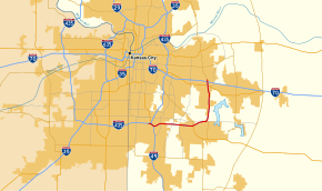
Interstate 470 (I-470) is a 16.72-mile (26.91 km) loop of the Interstate Highway System that serves to link southeast Kansas City to Independence via Lee's Summit in Jackson County, Missouri. The western terminus of the freeway is at the Grandview Triangle interchange with I-49, I-435, U.S. Route 50 (US 50), and US 71 while the northern terminus is an cloverleaf interchange with I-70. The freeway travels west to east through southern Kansas City, curving towards the north at the Lee's Summit Municipal Airport and becoming concurrent with Missouri Route 291 (Route 291) as the highway travels north towards Independence.
An intermediate interchange with US 50 provides access to southern Jackson County, and to Raytown to the north via Route 350, a former alignment of US 50 before the construction of I-470. Plans for a southern freeway were first published in 1955, and the first portions of I-470 were completed in 1970. By 1983 the entire freeway was open to traffic. Since construction two new interchanges have been constructed, along with the expansion of the US 50 cloverleaf. In 2010, part of the freeway was closed by the Grandview Triangle due to a landslide underneath the freeway. Between about 38,000 and 75,000 vehicles use the freeway on an average day.
Route description

I-470 begins in southern Kansas City at the Grandview Triangle interchange with I-49, I-435, US 50, and US 71. The freeway, concurrent with US 50, travels east through grasslands before meeting the westernmost interchange, a diamond interchange with Blue Ridge Boulevard. A rail line belonging to Kansas City Southern Railway passes under the freeway west of the interchange.[4] The concurrent highways continue east through lightly populated Jackson County past a light residential zone, towards an interchange with Raytown Road. Raytown Road provides access to Longview Lake to the south of I-470. Crossing into urbanized Lee's Summit, the Kansas City Metropolitan Junior College is accessible from the View High Drive interchange. The city line between Kansas City and Lee's Summit is near View High Drive. Exit 7 consists of a cloverleaf interchange with the southern end of Route 350 and US 50, as well as Northwest Blue Parkway and Northwest Pryor Road. Two rail lines surround the cloverleaf interchange, both operated by the Union Pacific Railroad, however only the eastern line is operational.[4] US 50 leaves the freeway and travels southeast as I-470 curves to the north near the Lee's Summit Municipal Airport.[5]
A partial interchange with Northeast Colburn Road is quickly followed by a partial interchange with Route 291, which becomes concurrent with I-470 as it heads north towards Independence. Just north of the airport is an interchange with Strother Road, followed by an interchange with Woods Chapel Road. Lakewood Lakes, a pair of connected lakes, passes to the west of the freeway as it travels north. Lakewood Lakes was home to the Lollapalooza music festival in 1996.[6] An interchange with Northeast Bowlin Road serves as an access road to Blue Springs Lake to the east of the freeway. US 40, which parallels I-70 through most of Missouri is the penultimate exit, serving the southern portions of Independence and Blue Springs. US 40 is named after Corporal Michael E. Webster, a Missouri State Highway Patrol officer who was killed in the line of duty by a drunk driver.[7] The northern terminus of I-470 is at a cloverleaf interchange with I-70 southwest of the Independence Center mall. The roadway continues north after the interchange with I-70 as Route 291 towards its ultimate end point at an interchange with I-435.[5]
Every three years, the Missouri Department of Transportation (MoDOT) conducts a series of surveys on its highways in the state to measure traffic volume. This is expressed in terms of annual average daily traffic (AADT), which is a measure of traffic volume for any average day of the year. In 2009, MoDOT calculated that as few as 38,152 vehicles traveled along the highway at the northern terminus just north of the interchange with I-70, and as many as 75,647 vehicles used the highway just east of the Grandview Triangle.[8] As part of the Interstate Highway System,[9] the entire route is listed on the National Highway System, a system of roads that are important to the nation's economy, defense, and mobility.[10]
History
Plans for a freeway linking southeast Kansas City to Independence were first published in 1955 in a document titled General Location of National System of Interstate Highways Including All Additional Routes at Urban Areas.[11] The first portions of the highway that were signed I-470 were established in 1970, between I-70 and US 40 in Independence. The north-south portion of the highway, then designated US 71 Bypass had been in existence since 1970 and was renumbered to Route 291 between 1970 and 1971.[2][12] Between 1979 and 1980, the portion of the freeway between the Grandview Triangle and the Exit 7 cloverleaf had been completed. US 50's alignment was changed to follow I-470 west to the Grandview Triangle, and the old routing of US 50 was renumbered Route 350.[13] The section of freeway between US 50 and Route 291 was opened to traffic in 1983, completing the route. Between 1980 and 1983, the portion of the route that is concurrent with Route 291 was upgraded to freeway standards and included in the I-470 loop.[3]
Since construction of the highway, three interchanges have been added or expanded. The first addition was an interchange with View High Drive, which was constructed in early 1993 costing about $2 million to complete.[14] The second was an addition to the existing cloverleaf at US 50 in Lee's Summit, adding access roads to Pryor Road and Northwest Blue Parkway. Construction on that interchange began in July 2007,[15] and was completed by September 2008.[16] The third interchange, with Strother Road was first planned to be constructed in 2008. The road served to provide access to the industrial park west of the freeway, and to spur new development on land pending sale by The Church of Jesus Christ of Latter-day Saints to the east of the freeway.[17] The interchange was opened to traffic in August 2010 at a final construction cost of around $18 million.[18]
In July 2010, MoDOT closed the westbound lanes of I-470 near the Grandview Triangle due to large cracks that formed in the roadway.[19] A buildup of ground water underneath the westbound lanes caused a 42-foot-high (13 m) retaining wall to fall or fail. A landslide occurred on July 17 which created a 35-by-200-foot (11 m × 61 m) hole in the roadway. The eastbound lanes were not affected and were not closed. The affected area was replaced by a 225-foot-long (69 m) bridge extension that opened in the following month.[20][21]
Exit list
The entire route is in Jackson County.
| Location | mi[1] | km | Exit[1] | Destinations | Notes | |
|---|---|---|---|---|---|---|
| Kansas City | 0.000– 0.596 | 0.000– 0.959 | — 1B | I-435 exit 71A; Western terminus at the Grandview Triangle; western end of US 50 overlap. | ||
| 0.615– 1.000 | 0.990– 1.609 | 1A | I-49 exit 183; southern end of the Grandview Triangle. | |||
| 2.083 | 3.352 | 2 | Blue Ridge Boulevard | |||
| 4.076 | 6.560 | 4 | Raytown Road | |||
| Lee's Summit | 5.354 | 8.616 | 5 | View High Drive | Western ramps are partially located in Kansas City | |
| 6.637– 8.148 | 10.681– 13.113 | 7C | Pryor Road, Blue Parkway | |||
| 7.599– 7.645 | 12.229– 12.303 | 7A‑B | Eastern end of US 50 overlap; signed as exits 7A (south) and 7B (north) | |||
| 9.286 | 14.944 | 9 | Douglas Street – Lee's Summit Municipal Airport | |||
| 10.067 | 16.201 | 10A | Colbern Road | Westbound exit and northbound entrance only. Southbound becomes Westbound; Eastbound becomes Northbound. | ||
| 10.318– 10.418 | 16.605– 16.766 | 10B | Southern end of Route 291 overlap, northbound entrance and westbound exit only | |||
| 11.636 | 18.726 | 11 | Strother Road | |||
| 12.644 | 20.349 | 12 | Woods Chapel Road | |||
| 14.158 | 22.785 | 14 | Lakewood Boulevard, Bowlin Road | |||
| Independence | 16.187– 16.198 | 26.050– 26.068 | 16A | |||
| 16.493– 17.081 | 26.543– 27.489 | 16B‑C | I-70 exits 15A-B; northern terminus & signed as exits 16B (east) & 16C (west). | |||
| 17.081 | 27.489 | — | Continuation past I-70; northern end of Route 291 overlap | |||
1.000 mi = 1.609 km; 1.000 km = 0.621 mi
| ||||||
See also
 U.S. Roads portal
 Missouri portal
References
- 1 2 3 Missouri Department of Transportation (March 13, 2014). Flex Map Viewer (Map). Missouri Department of Transportation. Retrieved March 13, 2014.
- 1 2 Missouri Official Highway Map (PDF) (Map). Missouri State Highway Commission. 1970. Kansas City inset. Retrieved February 19, 2011.
- 1 2 Missouri Official Highway Map (PDF) (Map). Missouri Highway and Transportation Commission. 1983. Kansas City inset. Retrieved February 19, 2011.
- 1 2 Missouri Rail Freight Carriers (PDF) (Map). Missouri Department of Transportation. June 2009. Kansas City inset.
- 1 2 Google (February 19, 2011). "Interstate 470" (Map). Google Maps. Google. Retrieved February 19, 2011.
- ↑ Beauchamp, Lane (June 27, 1996). "Lollapa-lake-a! Lollapalooza Fest Busts out of Traditional Venues for Concert at Longview Lake". The Kansas City Star. The McClatchy Company. p. F1.
- ↑ Barr, Paula (October 4, 1995). "Highway Renamed for Trooper: Michael E. Webster Was Struck and Killed by a Drunken Driver". The Kansas City Star. The McClatchy Company. p. C3.
- ↑ District 4 Traffic Volume and Commercial Vehicle Count Map (PDF) (Map). Missouri Department of Transportation. 2009. Retrieved February 19, 2011.
- ↑ Slater, Rodney E. (Spring 1996). "The National Highway System: A Commitment to America's Future". Public Roads. 59 (4). ISSN 0033-3735. Retrieved January 24, 2011.
- ↑ National Highway System: Kansas City MO-KS (PDF) (Map). Federal Highway Administration. November 2003. Retrieved February 19, 2011.
- ↑ General Location of National System of Interstate Highways Including All Additional Routes at Urban Areas (Map). U.S. Bureau of Public Roads. September 1955. Kansas City, Missouri inset.
- ↑ Missouri Highway Map (PDF) (Map). Missouri Official Highway Commission. 1971. Kansas City inset. Retrieved February 19, 2011.
- ↑ Missouri Highway Map (PDF) (Map). Missouri Highway and Transportation Commission. 1980. Kansas City inset. Retrieved February 19, 2011.
- ↑ "Road Work Expected to Open up Traffic to Western Lee's Summit". The Kansas City Star. The McClatchy Company. March 4, 1993.
- ↑ Pulley, Russ (July 14, 2007). "Work is to Start This Month on an Interchange Pryor, I-470". The Kansas City Star. The McClatchy Company. p. LS1.
- ↑ Hoffmann, Kevin (September 20, 2008). "Navigation: Road Work is Frustrating, but Signals Progress". The Kansas City Star. The McClatchy Company. p. LS2.
- ↑ Coleman-Topi, Debbie (July 5, 2008). "Strother Road Project Will Give Access to I-470". The Examiner. Independence, Mo. Archived from the original on February 20, 2011. Retrieved February 19, 2011.
- ↑ "Ceremony to Open New Interchange at I-470 and Strother Road in Lee's Summit". The Kansas City Star. The McClatchy Company. August 19, 2010.
- ↑ "Part of Key Interchange in KC is Closed". St. Louis Post-Dispatch. Lee Enterprises. Associated Press. July 19, 2010. pp. A12.
- ↑ Parsons, Jim (August 2, 2010). "MoDOT Moves To Replace Failed Kansas City Highway Ramp". Engineering News-Record. 265 (4). p. 14.
- ↑ Cooper, Brad (August 27, 2010). "Three Trails Crossing Ramp, Closed After a Section Collapsed, is to Reopen Today". The Kansas City Star. The McClatchy Company. p. A4.
External links
 Media related to Interstate 470 (Missouri) at Wikimedia Commons
- Interstate 470 in Missouri on Interstate-Guide.com
- Interstate 470 in Missouri on Missouri Highways Route Log
1Former | ||