Harrisonville, Missouri
| Harrisonville, Missouri | |
|---|---|
| City | |
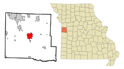 Location in the state of Missouri | |
| Coordinates: 38°39′13″N 94°20′49″W / 38.65361°N 94.34694°WCoordinates: 38°39′13″N 94°20′49″W / 38.65361°N 94.34694°W | |
| Country | United States |
| State | Missouri |
| County | Cass |
| Incorporated | 1851[1] |
| Government | |
| • Mayor | Brian Hasek |
| Area[2] | |
| • Total | 10.01 sq mi (25.93 km2) |
| • Land | 9.88 sq mi (25.59 km2) |
| • Water | 0.13 sq mi (0.34 km2) |
| Elevation | 951 ft (290 m) |
| Population (2010)[3] | |
| • Total | 10,019 |
| • Estimate (2012[4]) | 10,008 |
| • Density | 1,014.1/sq mi (391.5/km2) |
| Time zone | CST (UTC-6) |
| • Summer (DST) | CDT (UTC-5) |
| ZIP code | 64701 |
| Area code(s) | 816 |
| FIPS code | 29-30610[5] |
| GNIS feature ID | 0719166[6] |
| Website |
ci |
Harrisonville is a city in Cass County, Missouri, United States. The population was 10,019 at the 2010 census. It is the county seat of Cass County.[7]
History
Harrisonville was founded in 1837 upon land donated to Cass County by Congress for county purposes, and was named for Congressman Albert G. Harrison, who was instrumental in obtaining the land grant.[8] The area suffered greatly during the American Civil War, though Harrisonville was one of the few places exempted in Union General Thomas Ewing's notorious General Order No. 11 (1863), which ordered the depopulation of three entire Missouri counties and part of a fourth.[9]
In 1972, Harrisonville was the site of escalating tensions between a handful of would-be hippies—mostly Vietnam veterans—and town elders, which culminated in a brief rampage by 25-year-old Charlie "Ootney" Simpson. In the town square, in plain view of onlookers, he killed two police officers and a bystander before shooting himself. The victims were officers Donald Marler and Francis Wirt and local businessman Orville Allen. His motivation turned out to be personal, not political; he had saved money to buy a farm, but the seller had recently backed out of the deal, and Simpson had used the money to bail his friends out of jail.[10]
The Robert A. Brown House, Harrisonville Courthouse Square Historic District, and St. Peter's Episcopal Church are listed on the National Register of Historic Places.[11]
Geography
Harrisonville is located at 38°39′13″N 94°20′49″W / 38.65361°N 94.34694°W (38.653592, -94.346915).[12] According to the United States Census Bureau, the city has a total area of 10.01 square miles (25.93 km2), of which, 9.88 square miles (25.59 km2) is land and 0.13 square miles (0.34 km2) is water.[2]
Demographics
| Historical population | |||
|---|---|---|---|
| Census | Pop. | %± | |
| 1860 | 675 | — | |
| 1870 | 1,032 | 52.9% | |
| 1880 | 1,113 | 7.8% | |
| 1890 | 1,645 | 47.8% | |
| 1900 | 1,844 | 12.1% | |
| 1910 | 1,947 | 5.6% | |
| 1920 | 2,073 | 6.5% | |
| 1930 | 2,306 | 11.2% | |
| 1940 | 2,322 | 0.7% | |
| 1950 | 2,530 | 9.0% | |
| 1960 | 3,510 | 38.7% | |
| 1970 | 5,052 | 43.9% | |
| 1980 | 6,372 | 26.1% | |
| 1990 | 7,683 | 20.6% | |
| 2000 | 8,946 | 16.4% | |
| 2010 | 10,019 | 12.0% | |
| Est. 2015 | 9,986 | [13] | −0.3% |
2010 census
As of the census[3] of 2010, there were 10,019 people, 3,854 households, and 2,516 families residing in the city. The population density was 1,014.1 inhabitants per square mile (391.5/km2). There were 4,144 housing units at an average density of 419.4 per square mile (161.9/km2). The racial makeup of the city was 95.0% White, 1.1% African American, 0.7% Native American, 0.6% Asian, 0.8% from other races, and 1.7% from two or more races. Hispanic or Latino of any race were 2.6% of the population.
There were 3,854 households of which 36.6% had children under the age of 18 living with them, 44.7% were married couples living together, 15.3% had a female householder with no husband present, 5.3% had a male householder with no wife present, and 34.7% were non-families. 29.6% of all households were made up of individuals and 13.9% had someone living alone who was 65 years of age or older. The average household size was 2.49 and the average family size was 3.07.
The median age in the city was 35.5 years. 27.1% of residents were under the age of 18; 8.4% were between the ages of 18 and 24; 26.6% were from 25 to 44; 22.4% were from 45 to 64; and 15.5% were 65 years of age or older. The gender makeup of the city was 47.2% male and 52.8% female.
2000 census
As of the census[5] of 2000, there were 8,946 people, 3,457 households, and 2,302 families residing in the city. The population density was 1,035.2 people per square mile (399.8/km²). There were 3,646 housing units at an average density of 421.9/sq mi (162.9/km²). The racial makeup of the city was 96.15% White, 0.97% African American, 0.66% Native American, 0.47% Asian, 0.01% Pacific Islander, 0.39% from other races, and 1.34% from two or more races. Hispanic or Latino of any race were 1.41% of the population.
There were 3,457 households out of which 35.5% had children under the age of 18 living with them, 50.6% were married couples living together, 12.4% had a female householder with no husband present, and 33.4% were non-families. 28.9% of all households were made up of individuals and 14.0% had someone living alone who was 65 years of age or older. The average household size was 2.48 and the average family size was 3.05.
In the city the population was spread out with 27.6% under the age of 18, 8.1% from 18 to 24, 29.4% from 25 to 44, 19.6% from 45 to 64, and 15.3% who were 65 years of age or older. The median age was 35 years. For every 100 females there were 87.4 males. For every 100 females age 18 and over, there were 82.8 males.
The median household income was $39,498, and the median family income was $47,761. Males had a median income of $31,931 versus $22,416 for females. The per capita income for the city was $17,280. About 4.7% of families and 6.5% of the population were below the poverty line, including 8.4% of those under age 18 and 5.1% of those age 65 or over.
Media
Parts of the 1983 nuclear apocalyptic film The Day After are set in Harrisonville.
Notable people
- Robert Cook Bell, United States federal judge.
- Delmer Brown, Japanologist.
- Vicky Hartzler, U.S. Representative for Missouri's 4th congressional district since 2011.
- Chris Koster, 41st Attorney General of Missouri
- Edward Capehart O'Kelley, The man who killed Robert Ford, who killed Jesse James.
- Angelica Bridges, actress, model and singer.
References
- ↑ http://ci.harrisonville.mo.us/index.aspx?NID=18
- 1 2 "US Gazetteer files 2010". United States Census Bureau. Retrieved 2012-07-08.
- 1 2 "American FactFinder". United States Census Bureau. Retrieved 2012-07-08.
- ↑ "Population Estimates". United States Census Bureau. Retrieved 2013-05-30.
- 1 2 "American FactFinder". United States Census Bureau. Retrieved 2008-01-31.
- ↑ "US Board on Geographic Names". United States Geological Survey. 2007-10-25. Retrieved 2008-01-31.
- ↑ "Find a County". National Association of Counties. Retrieved 2011-06-07.
- ↑ Eaton, David Wolfe (1916). How Missouri Counties, Towns and Streams Were Named. The State Historical Society of Missouri. p. 272.
- ↑ http://www.harrisonvillechamber.com/livinghistory2.html
- ↑ Eszterhas, Joe, Charlie Simpson's Apocalypse. Random House, 1974.
- ↑ National Park Service (2010-07-09). "National Register Information System". National Register of Historic Places. National Park Service.
- ↑ "US Gazetteer files: 2010, 2000, and 1990". United States Census Bureau. 2011-02-12. Retrieved 2011-04-23.
- ↑ "Annual Estimates of the Resident Population for Incorporated Places: April 1, 2010 to July 1, 2015". Retrieved July 2, 2016.
- ↑ "Census of Population and Housing". Census.gov. Retrieved June 4, 2015.
External links
- City of Harrisonville
- Historic maps of Harrisonville in the Sanborn Maps of Missouri Collection at the University of Missouri
Municipalities and communities of Cass County, Missouri, United States | ||
|---|---|---|
| Cities | 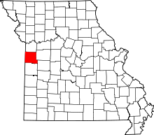 | |
| Villages | ||
| Townships | ||
| Unincorporated communities | ||
| Ghost towns | ||
| Footnotes | ‡This populated place also has portions in an adjacent county or counties | |
Kansas City metropolitan area's cities and counties | ||
|---|---|---|
| Central city |  | |
| Largest cities (over 100,000 in 2000) | ||
| Medium-sized cities (10,000 to 100,000 in 2000) | ||
| Smaller Cities (between 5,000 and 9,900 in 2010) | ||
| Counties | ||