Sedalia, Missouri
| Sedalia, Missouri | |
|---|---|
| City | |
 Location of Sedalia, Missouri | |
| Coordinates: 38°42′11″N 93°13′52″W / 38.70306°N 93.23111°WCoordinates: 38°42′11″N 93°13′52″W / 38.70306°N 93.23111°W | |
| Country | United States |
| State | Missouri |
| County | Pettis |
| Government | |
| • Mayor | Steven Galligher |
| Area[1] | |
| • Total | 13.32 sq mi (34.50 km2) |
| • Land | 13.29 sq mi (34.42 km2) |
| • Water | 0.03 sq mi (0.08 km2) |
| Elevation | 909 ft (277 m) |
| Population (2010)[2] | |
| • Total | 21,387 |
| • Estimate (2012[3]) | 21,476 |
| • Density | 1,609.3/sq mi (621.4/km2) |
| Time zone | Central (CST) (UTC-6) |
| • Summer (DST) | CDT (UTC-5) |
| ZIP codes | 65301-65302 |
| Area code(s) | 660 |
| FIPS code | 29-66440[4] |
| GNIS feature ID | 0729812[5] |
| Website | www.cityofsedalia.com |
Sedalia, Missouri is a city located about 30 miles (48 km) south of the Missouri River in Pettis County. As of the 2010 census, the city had a total population of 21,387.[6] As the county seat of Pettis County,[7] it is the principal city of the Sedalia Micropolitan Statistical Area, which consists of Pettis County. Sedalia is also the location of the Missouri State Fair and the Scott Joplin Ragtime Festival. U.S. Routes 50 and 65 intersect in the city.
History

Indigenous peoples lived along the Missouri River and its tributaries for thousands of years before European contact. Historians believe the entire area around Sedalia was long occupied by the Osage (among historical American Indian tribes). When the land was first settled by European Americans, bands of Shawnee, who had migrated from east of the Mississippi River, lived in the vicinity of Sedalia.[8]
The area that became the European-American city of Sedalia was founded by General George Rappeen Smith (1804–1879), who also founded nearby Smithton, Missouri. He filed plans for the official record on November 30, 1857, and gave the area the name Sedville.[9] The original plat included the land from today's Missouri Pacific Railroad south to Third Street. In addition, the version filed jointly by General Smith and David W. Bouldin on October 16, 1860, displayed the city extending from Clay Street to the north and to Smith Street (today's Third Street) in the south, and from Missouri Street in the west to Washington Street in the east. Smith and Bouldin anticipated that the city would grow to the north; however, it grew in a southern direction.[10]
During the American Civil War, the U.S. Army had an installation in the area, adding to its boomtown atmosphere of accelerated development as merchants and traders attracted to the military business came to the area. In the post-Civil War period, two railroads were constructed connecting it to other locations and Sedalia grew at a rapid pace, with a rough energy of its travelers and cowboys. From 1866–1874, it was a railhead terminus for cattle drives, and stockyards occupied a large area. At the same time, the town established schools (racially segregated for white and black children), churches, and other civic amenities.[11]
In the late 19th century, Sedalia was well-known as a center of vice, especially prostitution, which accompanied its large floating class of railroad workers and commercial travelers. In 1877 the St. Louis Post-Dispatch called Sedalia the "Sodom and Gomorrah of the nineteenth century." Middle-class businessmen made money off illegal prostitution as building owners and lessees; others did business with people in the industry, who banked, used lawyers, etc., in town. Reluctant to raise taxes, residents allowed money to run the city. Services were provided from the fines charged to prostitutes.
In the 1870s brothels were distributed throughout the city, but in the 1890s, they became more concentrated above businesses on West Main Street, as the middle class tried to isolate less desirable elements in town.[12] These establishments also employed musicians, particularly piano players, contributing to a thriving musical culture. It fostered the development of many artists, including the renowned ragtime composer Scott Joplin.
While the city attracted many commercial travelers and railroad workers, its population of married couples and families also grew. By 1900 its population of more than 15,000 made it the fifth-largest city in the state. The entrepreneurial middle class created more formal separations between its residential areas and those of working class whites and African Americans.[11]
During World War II, the military built Sedalia Glider Base in Johnson County to the west. After the war, this facility was transferred to the Strategic Air Command. It was converted to a bomber base, the Whiteman Air Force Base, named after a man from Sedalia who had been killed in the 1941 Japanese attack at Pearl Harbor. After a massive construction program, the base became the center of 150 ICBM silos and administrative offices. These were decommissioned in the 1990s.
Name
Until the city was incorporated in 1860 as Sedalia, it had existed only "on paper" from November 30, 1857 to October 16, 1860. According to local lore, the town council changed the name from Sedville to Sedalia in part because "towns that end in -ville don't amount to anything." (Lawrence Ditton Sr.). Here is another account:
In 1856 General Smith bought the land upon which Sedalia now stands, and founded the city. He named it after his daughter Sarah, familiarly known as "Sed". Smith remarked that he had previously named a flatboat for her elder sister Martha. He first chose the name Sedville but changed it to Sedalia,[13] following the suggestion of a friend, Josiah Dent, of St. Louis. Dent suggested the change for the sake of euphony.[14]
Railhead
Following a victory for those proposing the "ridge route" for the railway over those advocating the "river route", the railway reached Sedalia in January 1861.[15] Sedalia's early prosperity was directly related to the railroad industry. Many jobs were associated with men maintaining tracks and operating large and varied machine shops run by both the Missouri Pacific and the Missouri-Kansas-Texas Railroad lines. The Missouri-Kansas & Texas Railroad was widely known as the "KATY," from its "K-T" stock exchange code.
Sedalia was an important railhead for the massive Texas cattle drive of 1866. It maintained stockyards to receive cattle from drives and shipping through much of the 19th century.
.JPG)
Chicago slaughterhouses were willing to pay almost any price [for beef]—longhorns were worth three to four dollars each on the Llano Estacado while in Chicago a steer was worth ten times that amount. It cost about a dollar per head to drive a herd northward to a railroad, and thus with these simple economics, the long drive and the cattle bonanza got its start.
During the spring and summer of 1866, some 260,000 head followed the trail to Sedalia, Missouri, the terminus of the Missouri Pacific Railroad." (McComb, 1989, p.84).
For nearly a century, Sedalia's economy was tied to the railroads. By the end of the 19th century, the MK&T had numerous buildings and a wide variety of workers in the city: the MK&T shops, stockyards, roundhouse, and the hospital for employees working in the Sedalia Division were among the Katy’s properties in Sedalia.
After the KATY reduced its operations in the 20th century, its railroad right-of-way through much of Missouri was converted to a 225-mile paved trail. The KATY Trail is used by bikers, walkers and horseback riders. This has been the largest new trail developed in the nation among the late 20th-century federal and state "Rails to Trails" projects.
Civil War
Sedalia was made a military post early in the war and remained such until its close in 1865. For this reason it was an active theater of operations for military supplies and an objective point for capture by "the boys in gray." Confederate raids into Pettis County, and the offensive and defensive activities of Union troops against them, kept the inhabitants of Sedalia in [a] high state of excitement. The progress of the city was retarded [during that time]. Sentiment in the county was about evenly divided.[16]
During the Civil War, despite the presence of the Union soldiers guarding the railroad, Sedalia was almost taken by the Confederate forces of Major General Sterling Price. Some 1,500 of General Joseph O. Shelby's Iron Brigade cavalry associated with Price's Missouri Expedition surrounded Sedalia, overpowered the Union militia under command of Colonel John D. Crawford and Lieutenant Colonel John [?D.] Parker, and began to loot and sack the town on October 15, 1864.[17] Once Confederate General M. Jeff Thompson arrived in Sedalia, he ordered his men to stop the destruction and moved them on, leaving Sedalia in Union hands.[18]
While the Civil War delayed development of the town in some respects, Sedalia was the terminus of the railroad for three years. Once the war was over, many of the thousands of Union soldiers who had been stationed more or less permanently at Sedalia and recognized its potential, made the choice to migrate there from their former homes in other areas. The population grew rapidly.[19]
The Salvation Army
The Salvation Army opened its doors in Sedalia, Missouri in 1886 with none other present that William Booth himself, having traveled all the way from London to attend the event. When Captain George Parks was asked by The Sedalia Democrat why William Booth had purposed to locate "his salvation army" in Sedalia, Parks responded, "Because Sedalia is a desperately wicked city and if souls can be won to Christ in Sedalia, they can be won to Christ anywhere." Parks was later beaten so severely in downtown Sedalia that he traveled home to Chicago where he died nearly a year later from his wounds, making him the first martyr for The Salvation Army in the United States.[20]
20th century – present
The expansion of the railroad and cattle drives in the late 19th century brought many male laborers to the rough town on the frontier. It sparked the related rise of a notorious "red light district," with numerous prostitutes who did business with the men in saloons and brothels, which also featured musical entertainments.
As more families settled in the area, they made the culture more stable, creating institutions such as schools and churches. In the late 20th century, structural changes in the railroads meant the loss of many industrial jobs, but the city has held on to a population close to its 1960 peak while developing new bases for the economy. The city is informally known as the "Trailer Capital of the Midwest," due to the high number of trailer manufacturers and dealers in the area.
Residents have emphasized the colorful history of the town for heritage tourism, and identified many significant historic structures for state and national recognition. Good quality retail and craft items are sold in the historic districts and buildings of the city.
Registered Historic Places
The following Sedalia locations have been listed on the National Register of Historic Places:[21]
- Building at 217 West Main Street, former brothel
- C.C. Hubbard High School
- Harris House
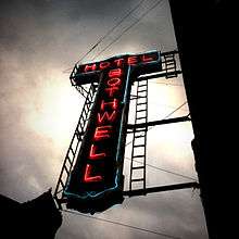
- Hotel Bothwell
- McVey School
- Missouri, Kansas and Texas Railroad Depot
- Missouri/Sedalia Trust Company
- Missouri State Fairgrounds Historic District
- Sedalia Commercial Historic District
- Sedalia Public Library
- William H. Gentry House
Geography
Sedalia is located at 38°42'11" North, 93°13'52" West (38.702918, -93.231147).[22] According to the United States Census Bureau, the city has a total area of 13.32 square miles (34.50 km2), of which 13.29 square miles (34.42 km2) is land and 0.03 square miles (0.08 km2) is water.[1]
Climate
Sedalia has a typical temperate climate. As with most continental climates, the micropolitan area has four seasons. Springs in Sedalia are noted for their rainy days and variable temperatures. Thunderstorms are common and tornadoes occur during this time of year. Summers are usually hot and humid, with droughts occurring during several summers. Autumns are usually cool and rainy, although several days of warm weather are not uncommon. Winters are generally cold, with snow accumulating several days of the winter season. Although not as common, ice storms occur as well.
Demographics
| Historical population | |||
|---|---|---|---|
| Census | Pop. | %± | |
| 1870 | 4,560 | — | |
| 1880 | 9,561 | 109.7% | |
| 1890 | 14,068 | 47.1% | |
| 1900 | 15,231 | 8.3% | |
| 1910 | 17,822 | 17.0% | |
| 1920 | 21,144 | 18.6% | |
| 1930 | 20,806 | −1.6% | |
| 1940 | 20,428 | −1.8% | |
| 1950 | 20,354 | −0.4% | |
| 1960 | 23,874 | 17.3% | |
| 1970 | 22,847 | −4.3% | |
| 1980 | 20,927 | −8.4% | |
| 1990 | 19,800 | −5.4% | |
| 2000 | 20,339 | 2.7% | |
| 2010 | 21,387 | 5.2% | |
| Est. 2015 | 21,516 | [23] | 0.6% |
| U.S. Decennial Census[24] | |||

Sedalia had a population of around 300 people in 1860, and what was described as a "bona fide population" of around 1,000 in 1865.[25][26] Sedalia has recently become home to many immigrants from Russia or former Soviet bloc nations, who may account for up to 15% of the population.[27]
2010 census
As of the census[2] of 2010, there were 21,387 people, 8,850 households, and 5,226 families residing in the city. The population density was 1,609.3 inhabitants per square mile (621.4/km2). There were 9,979 housing units at an average density of 750.9 per square mile (289.9/km2). The racial makeup of the city was 85.3% White, 5.2% African American, 0.5% Native American, 0.7% Asian, 0.1% Pacific Islander, 5.2% from other races, and 3.0% from two or more races. Hispanic or Latino of any race were 9.0% of the population.
There were 8,850 households of which 31.8% had children under the age of 18 living with them, 39.3% were married couples living together, 14.4% had a female householder with no husband present, 5.3% had a male householder with no wife present, and 40.9% were non-families. 34.1% of all households were made up of individuals and 13.6% had someone living alone who was 65 years of age or older. The average household size was 2.36 and the average family size was 3.00.
The median age in the city was 34.6 years. 24.8% of residents were under the age of 18; 11% were between the ages of 18 and 24; 26% were from 25 to 44; 23.2% were from 45 to 64; and 15.1% were 65 years of age or older. The gender makeup of the city was 48.0% male and 52.0% female.
2000 census
As of the census[4] of 2000, there are 20,339 people in the city, organized into 8,628 households and 5,228 families. The population density is 1,700.8 people per square mile (656.6/km²). There are 9,419 housing units at an average density of 787.6 per square mile (304.1/km²). The racial makeup of the city is 88.62% White, 4.95% African American, 0.40% Asian, 0.39% Native American, 0.02% Pacific Islander, 3.75% from other races, and 1.86% from two or more races. 5.55% of the population are Hispanic or Latino of any race.
There are 8,628 households out of which 28.8% have children under the age of 18 living with them, 44.0% are married couples living together, 12.6% have a female householder with no husband present, and 39.4% are non-families. 33.1% of all households are made up of individuals and 14.7% have someone living alone who is 65 years of age or older. The average household size is 2.32 and the average family size is 2.94.
In the city the population is spread out with 24.7% under the age of 18, 10.8% from 18 to 24, 27.7% from 25 to 44, 19.4% from 45 to 64, and 17.4% who are 65 years of age or older. The median age is 36 years. For every 100 females there are 90.0 males. For every 100 females age 18 and over, there are 86.3 males.
The median income for a household in the city is $28,641, and the median income for a family is $34,938. Males have a median income of $28,208 versus $19,520 for females. The per capita income for the city is $15,931. 15.3% of the population and 12.5% of families are below the poverty line. Out of the total population, 20.8% of those under the age of 18 and 10.5% of those 65 and older are living below the poverty line.
Culture
Carnegie Library
The Sedalia Public Library was the first Carnegie Grant awarded in Missouri. The Board of Trustees received word of the $50,000 grant in the fall of 1899. After securing the property on which to build, and having gained voter approval of a tax to support the library, the Board laid the cornerstone in 1900. The building was completed in July 1901.[28] Dedicated in 1901, the library is listed on the National Register of Historic Places.
Museums
Sedalia is home to the Daum Museum of Contemporary Art, named after its primary benefactor, Sedalia radiologist and art collector Harold Daum. The museum, located on the State Fair Community College campus, is home to the works of many famous artists including Dale Chihuly (1941–), Sam Francis (1923–1994), Helen Frankenthaler (1928–), Sol LeWitt (1928–2007), Robert Motherwell (1915–1991), Julian Schnabel (1951–), and Andy Warhol (1928–1987).
The 16,000-square-foot (1,500 m2) museum, designed by St. Louis-based Gunn & Smith Architects, features three stories of gallery space—including a 3,400-square-foot (320 m2) main gallery with a translucent clerestory, a cantilevered stairway, a two-story atrium, and an open-air sculpture court. It features both permanent displays as well as temporary displays from world-renowned artists.[29]

Sedalia is also home to The Pettis County Museum and Historical Society, located at 228 Dundee Ave. The building was once a Jewish Synagogue and features many Historical artifacts from all periods of Pettis County history. It is currently open on Friday and Saturday from 1:00pm to 4:00pm, and by appointment at other times.
State Fair
Since 1901, the Missouri State Fair has been held in Sedalia every August, with the exception of 1943 and 1944 because of World War II. Many singers and actors make the annual trip to the fair. Ronald Reagan, George W. Bush and other presidents have given speeches on the fairgrounds, though not during the State Fair.
In 1974, the Missouri State Fairgrounds was the site of the Ozark Music Festival, one of the largest but least remembered major music festivals of the 1970s. While the plan was for the pop/rock/bluegrass festival's selling about 50,000 tickets, an influx of about 184,000 fans and many rock bands strained the capacity of the fairgrounds and the city. Some estimates put the crowd count at 350,000. It counts as one of the largest music events (Rock Festivals) in history. The festival, hosted by Wolfman Jack, took out a full-page ad in Rolling Stone magazine and attracted people from outside the region.
Film
In the American television movie The Day After (1983), aired by ABC, Sedalia is destroyed when the Soviet Union attacks the Minuteman II Missile silos around the area. At the time of the movie's release, 150 of the missiles were located in the Sedalia area in underground silos. They had been sited there since activation in early 1964 of the first Minuteman missiles under the control of the 351st Missile Wing located at Whiteman Air Force Base. The release of the movie led to a significant (if belated) increase in local community concern about the missiles. Concern remained high until all the missiles were dismantled between 1992 and 1997 as a result of the Strategic Arms Reduction Treaty between the United States and Russia.

Sedalia was featured in two widely seen 1977 films: Heroes, starring Henry Winkler and Harrison Ford; and the made-for-TV movie Scott Joplin, starring Billy Dee Williams.[30]
Sedalia was mentioned briefly in the motion picture MASH. Parts of the 1941 film Bad Men of Missouri are set in Sedalia. The city was mentioned in Old Yeller.
Television
The classic, long running Western series Rawhide, which ran on CBS from 1959 to 1966, featured Sedalia as a destination for cattle drives. It starred Eric Fleming as the trail boss, Gil Favor, and the emerging Clint Eastwood as the "ramrod" (i.e., second in charge), Rowdy Yates.

Music
Sedalia is well known as the adopted home of ragtime music's most well known musician and stylist Scott Joplin.
In 1935, in the midst of the depression which affected Sedalia severely, Abe Rosenthal along with some other music-loving residents formed the Sedalia Symphony Society and established a Symphony orchestra, which, as the second oldest in Missouri, celebrated its 75th season in 2009–2010.
Sedalia has been the host to several rock and roll events, such as the Ozark Music Festival in 1974, and the Delicious Rox Festival in 2006.
Little Sister of Liberty
In 1950, to celebrate its fortieth anniversary—which had the theme of "Strengthen the Arm of Liberty"[31]—the Boy Scouts of America donated two hundred 8 ft 6in (260 cm) copper replicas of the Statue of Liberty, which were known collectively as the "Little Sisters of Liberty", to various communities in 39 states. The project was the brainchild of the Scout Commissioner of the (then) Kansas City Area Council, Kansas City businessman J.P. Whitaker.
One of the 200 replicas was donated to Sedalia; and it was installed at the County Courthouse.[32][33]
Boy Scouts of America
According to The History of the Boy Scouts of America (William D. Murray, 1937), the first Boy Scout Troop in Missouri (and one of the first in the nation) was formed in Sedalia in 1909, a year before the national organization was officially chartered on February 8, 1910.
Media
Newspapers
A number of newspapers have been published in Sedalia, in alphabetical order:
- The Daily Democrat (1871–1873)
- The Independent Press (1871–1873)
- The Pacific Enterprise (1863–1864)
- The Sedalia Advertiser (1864–1865)
- The Sedalia Bazoo (1881–1895)
- The Sedalia Capital
- The Sedalia Daily Democrat (1874–1925)
- The Sedalia Democrat (1949–)
- The Sedalia News-Journal (2003–)
- The Sedalia Times
Radio stations
- KSDL 92.3FM (Sedalia)
- KSIS 1050 AM (Sedalia)
- KXKX 105.7 FM (Sedalia)
- KDRO 1490 AM (Sedalia)
- KPOW 97.7 FM (Sedalia)
Television stations
- KMOS-TV (Channel 6)
- K11OJ-TV (Channel 11)
Education
Scott Joplin's alma mater, George R. Smith College, a historically black college (HBCU), operated from 1894 until it burned down on April 26, 1925.[34]
George R. Smith College, erected to provide educational training for Negro students was located a short distance southwest of Crown Hill Cemetery. It was a brick structure trimmed with stone. The building contained three stories with 60 rooms, and a general assembly room with a seating capacity of 300 people. The cost of the building was $50,000. In January 1896 there were 125 students enrolled. This building was destroyed by fire in 1925. The date of the erection was not obtainable. The land was donated by Mesdames Smith and Cotton, daughters of George R. Smith, founder of Sedalia. The college was named in honor of George R. Smith. During the years of the existence of the college over 2,000 students received degrees.(Scotton, 1974, p.164)
The land for the college had been donated by the Smith sisters Sarah and Martha Elizabeth. They also donated land for Dunbar Park. Sarah Smith-Cotton's family home was torn down and the land was then used for the building of Smith-Cotton High School.[35]
The Sedalia Business College and Institute of Penmanship was founded in 1881. It was the predecessor of Robbins' Business College, founded by Clark W. Robbins (1858–1918) in 1883. This evolved into Central Business College.[36]
State Fair Community College is a public two-year institution offering post-secondary college level courses.
Secondary schools
Smith-Cotton High School, Sacred Heart High School, and St. Paul's Lutheran are also located in Sedalia.
Transportation
Air
Train
Notable people
People born in, living in, or otherwise associated with Sedalia are known as Sedalians.
See also
References
- 1 2 "US Gazetteer files 2010". United States Census Bureau. Retrieved 2012-07-08.
- 1 2 "American FactFinder". United States Census Bureau. Retrieved 2012-07-08.
- ↑ "Population Estimates". United States Census Bureau. Retrieved 2013-05-30.
- 1 2 "American FactFinder". United States Census Bureau. Retrieved 2008-01-31.
- ↑ "US Board on Geographic Names". United States Geological Survey. 2007-10-25. Retrieved 2008-01-31.
- ↑ 2010 United States Census
- ↑ "Find a County". National Association of Counties. Retrieved 2011-06-07.
- ↑ Ihrig, et al., 1960, p.5.
- ↑ Ihrig, et al., 1960, p.8.
- ↑ Ihrig, et al., 1960, pp.2, 8.
- 1 2 Whites, LeeAnn; Neth, Mary; Kremer, Gary R. (June 14, 2004). Ladies of the Evening: Prostitution and Class in a 19th Century Railroad Town. Women in Missouri History: In Search of Power and Influence. Columbia, Missouri: University of Missouri. p. 152. ISBN 0-8262-1526-2.
- ↑ Whites (2004), "Ladies of the Evening," pp. 155-157
- ↑ Also christening the city "The Queen of the Prairies" (Ihrig, et al., 1960, p.9).
- ↑ "GEORGE R. SMITH", Rootsweb, accessed 10 February 2008. Website states content was “excerpted” from Conard, H.L. (ed), Encyclopedia of the History of Missouri (in Six Volumes), The Southern History Company, (New York), 1901; the volume and page numbers were not cited.
- ↑ Ihrig, et al., 1960, p.7.
- ↑ Ihrig, et al., 1960, p.10.
- ↑ "From Sedalia: It's Late Defence and Capture" (Missouri Democrat, October ?, 1864), History Sites
- ↑ Mueller, (2007), pp.85–86
- ↑ Ihrig, et al., 1960, p.13.
- ↑ The Salvation Army Historical Society, Chicago, Illinois.
- ↑ "Registered Historic Places in Pettis County, MO", Wikipedia
- ↑ "US Gazetteer files: 2010, 2000, and 1990". United States Census Bureau. 2011-02-12. Retrieved 2011-04-23.
- ↑ "Annual Estimates of the Resident Population for Incorporated Places: April 1, 2010 to July 1, 2015". Retrieved July 2, 2016.
- ↑ Ihrig et al., (1960 p. 123) also noted "There is considerable disagreement about the 1950 census, as critics contend that many people were missed. The "Survey on [sic] Buying Power" [viz., the Sales and Marketing Management magazine's annual Survey of Buying Power] indicates an estimated population of 26,300 on January 1, 1958. The 1960 census had not been taken when this [centenary] history was written, but the 1960 population of Sedalia was estimated to be between 28,000 and 30,000."
- ↑ Ihrig et al. (1960 p. 12)
- ↑ The significance of the description of "bona fide population" is that "from 1861 to 1864 Missouri was under martial law and Sedalia, as a military post, was governed by the post commander. There was no mayor, council or executive or legislative body except the military power" (Ihrig et al., 1960 p.12).
- ↑ http://russianamericanbusiness.org/web_CURRENT/articles/82/1/The-Most-Russian-City-in-the-U.S.
- ↑ Sedalia Public Library - Sedalia, MO [lib-web-cats]
- ↑ Kinzer, S., " IN THE MIDDLE; What's This? An Art Boom In the Heartland", New York Times, (24 April 2002), pp.E1–E2.
- ↑ "Scott Joplin (1977)". IMDb.com. Retrieved 2011-02-12.
- ↑ Attoun, M., "Little Sisters of Liberty", Scouting, (October 2007)
- ↑ Boy Scouts of America, Troop 101, Cheyenne, Wyoming: Replica Statue of Liberty Search (includes a photograph of Sedalia's "Little Sister of Liberty")
- ↑ The following unsigned tribute appeared on the plaque affixed to its base:
- WITH THE FAITH AND COURAGE OF
- THEIR FOREFATHERS WHO MADE
- POSSIBLE THE FREEDOM OF THESE
- UNITED STATES
- THE BOY SCOUTS OF AMERICA
- DEDICATE THIS REPLICA OF THE
- STATUE OF LIBERTY AS A PLEDGE
- OF EVERLASTING FIDELITY AND
- LOYALTY:
- 40TH ANNIVERSARY CRUSADE TO
- STRENGTHEN THE ARM OF LIBERTY
- 1950
- Taken from the Smithsonian American Art Museum's Inventory of American Sculpture, Control Number MO000269.
- ↑ The college was more widely known across the United States as the George R. Smith College for Negroes. Subsequent to the fire, an unsuccessful attempt was made (through the Methodist Church) to rebuild the college (Ihrig, et al., 1960, p.48).
- ↑ Swearingen, (?1995)."Sedalia's Founding Mothers: A Tribute", University of Missouri
- ↑ Conroy, (2009), pp. 15–25.
Further reading
- Berlin, E.A., "Scott Joplin in Sedalia: New Perspectives", Black Music Research Journal, Vol.9, No.2, (Autumn 1989), pp. 205–223.
- Bird, Kenneth L." Rails To The Osage", Menwith Productions, 2009, Story of the Sedalia, Warsaw & Southern Railroad ISBN 978-1-61584-215-5
- Cassity, M.J., Defending a Way of Life: An American Community in the Nineteenth Century, Albany, NY: State University of New York Press, 1989. ISBN 0-88706-868-5
- Cassity, M.J., Defending a Way of Life: The Development of Industrial Market Society and the Transformation of Social Relationships in Sedalia, Missouri 1850–1890, Ph.D. Dissertation, University of Missouri–Columbia, 1973.
- Chalfant, R., Down at the Junction: a study of Madam Lizzie Cook, a prostitute in Sedalia, Missouri, 1870–1879, M.A. Dissertation, University of Missouri, 1994.
- Chalfant, R., Show me the fair : a history of the Missouri State Fair, Walsworth Publications, (Marceline), 2002. ISBN 1-57864-189-6
- Chalfant, R., "The Midland's Most Notorious": A Study of Prostitution in Sedalia, Missouri, 1860–1900, Ph.D. Dissertation, University of Missouri–Columbia, 2005.
- Christensen, L.O.(ed), Dictionary of Missouri Biography, University of Missouri Press, (Columbia), 1999. ISBN 0-8262-1222-0
- Claycomb, W.B., On the Mainlines: Railroading in Sedalia, MO, W.B. Claycomb, (Hughesville), 1998.
- Claycomb, W.B., On the Mainlines: Railroading in Sedalia, Missouri, Sedalia Heritage Foundation, (Sedalia), 2003.
- Claycomb, W.B., Imhauser, B.C. & Nolen, R.M., Bothwell Regional Health Center: A Lifetime of Caring, 1930–2005, Bothwell Regional Health Center, (Sedalia), 2005.
- Conroy, M.S., The Cosmetics Baron You've Never Heard Of: E. Virgil Neal and Tokalon, Altus History LLC, (Englewood), 2009. ISBN 0-615-27278-9
- Crisler, R.M., "Cities of Central Missouri", Economic Geography, Vol.23, No.1, (January 1947), pp. 72–75.
- Demuth, I. M., The History of Pettis County, Missouri, including an authentic history of Sedalia, other towns and townships, together with... biographical sketches..., F. A. North, (Sedalia), 1882.
- Dickson, T., There's a Town in Missouri: Hermann, Hannibal, Springfield, St. Joseph, Joplin, Cape Girardeau, Fulton, Sedalia, Lamar, Lexington, Independence, St. Louis, 1902, New Sunrise Publishing, 1979.
- Hale, L.L., Sedalia, Missouri: 100 Years in Pictures, Walworth Publishing, (Marceline), 1960.
- Harding, S.B., Life of George R. Smith, Founder of Sedalia, Mo., in its Relations to the Political, Economic, and Social life of Southwestern Missouri, Before and During the Civil War, Kessinger Publishing, 2007 (facsimile, reprint of 1904). ISBN 1-4304-4460-6
- Ihrig, B.B. et al. (eds), The First One Hundred Years, A History of the City of Sedalia, Missouri, 1860–1960, Centennial History Committee, Sedalia, 1960.
- Imhauser, R.C., Images of America: Sedalia, Arcadia Publishing, (Charleston), 2007. ISBN 0-7385-5087-6
- Lang, H.N., Life in Pettis County, 1815–1873, Hazel N. Lang, (Sedalia), 1975.
- McComb, D.G., Texas: A Modern History, University of Texas Press, (Austin), 1989. ISBN 0-292-74665-2
- Mueller, D.L., M. Jeff Thompson: Missouri's Swamp Fox of the Confederacy, University of Missouri Press, (Columbia), 2007. ISBN 0-8262-1724-9
- Murray, William D., "The History of the Boy Scouts of America" Boy Scouts of America (New York) 1937 - Page 21* North, F.A., Hand-Book of Sedalia, Including Its History and Business Directory, F. A. North, (Sedalia), 1882.
- Peters, J.A., Case Study of a Gathering: The Ozark Music Festival, M.A. Dissertation, Central Missouri State University, 1992.
- Ruger, A., "Bird's eye view of the city of Sedalia, Pettis Co., Missouri 1869".
- Scotten, F.C., History of the Schools of Pettis County, Missouri, 1974; Prepared under the Direction of C. F. Scotten, C.F. Scotton, (Sedalia) 1974.
- Snider, R.L., The Show Must Go On. A Plan for Rehabilitating an Historic Theatre: Case Studies of Three Historic Theatre Rehabilitations in Missouri, Ph.D. Dissertation, University of Missouri–Columbia, 1999.
- Swearingen, "Sedalia's Founding Mother", Preservation Issues, Vol.4, No.2, ?1995.
- Thelen, D.P., Paths of Resistance: Tradition and Dignity in Industrializing Missouri, Oxford University Press, 1986. ISBN 0-19-503667-0
- Whites, L., Neth, M. & Kremer, G.R. (eds), Women in Missouri History: In Search of Power and Influence, University of Missouri Press, (Columbia), 2004. ISBN 0-8262-1526-2
- United States Department of the Interior, National Register of Historic Places, 217 West Main Street Building, Sedalia
- Yanow, S., Jazz: A Regional Exploration, Greenwood Press, (Westport), 2005. ISBN 0-313-32871-4
External links
| Wikimedia Commons has media related to Sedalia, Missouri. |
- Official website
- Missouri State Fair in Sedalia
- Scott Joplin International Ragtime Foundation in Sedalia
- Sedalia Convention and Visitors Bureau
- Sedalia Chamber of Commerce
- State Fair Community College in Sedalia
- The Katy Depot at Sedalia
- The Sedalia Democrat
- The Sedalia News-Journal
- The Political Graveyard: A Database of Historic Cemeteries
- The Sedalia Police Department
- The Sedalia Fire Department
- The Pettis County Sheriff's Office
- The Pettis County Fire Department
- This is America! (video) "Carol Highsmith talks to Becky Imhauser in the historic town of Sedalia, Missouri"
- Historic maps of Sedalia in the Sanborn Maps of Missouri Collection at the University of Missouri
- Sedalia Downtown Development Inc.
- The Sedalia Trust BuildingMunicipalities and communities of Pettis County, Missouri, United States
Cities 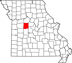
Villages Townships - Blackwater
- Bowling Green
- Cedar
- Dresden
- Elk Fork
- Flat Creek
- Green Ridge
- Heath Creek
- Houstonia
- Hughesville
- La Monte
- Lake Creek
- Longwood
- Prairie
- Sedalia
- Smithton
- Washington
Unincorporated
communitiesGhost towns Footnotes ‡This populated place also has portions in an adjacent county or counties