Interstate 370
| ||||
|---|---|---|---|---|
 | ||||
| Route information | ||||
| Auxiliary route of I-70 | ||||
| Maintained by MDSHA | ||||
| Length: | 2.54 mi[1] (4.09 km) | |||
| Existed: | 1988 – present | |||
| Major junctions | ||||
| West end: | Sam Eig Highway/Washingtonian Boulevard in Gaithersburg | |||
|
| ||||
| East end: |
| |||
| Location | ||||
| Counties: | Montgomery | |||
| Highway system | ||||
| ||||

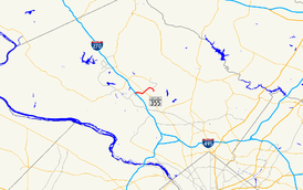
Interstate 370 (abbreviated I-370) is a 2.54-mile (4.09 km) Interstate Highway spur route off I-270 in Gaithersburg, Maryland to the western end of toll road Maryland Route 200 (MD 200, Intercounty Connector) at an interchange that provides access to the park and ride lot at the Shady Grove station on the Red Line of the Washington Metro. Despite the number, I-370 does not connect to I-70 itself. The road continues to the west of I-270 as Sam Eig Highway, a surface road. Along the way, I-370 has interchanges with MD 355 and Shady Grove Road. The freeway was completed in the late 1980s to connect I-270 to the Shady Grove Metro station. I-370 was always part of the planned Intercounty Connector, but was the only segment to be built at the time. The opening of MD 200 east of I-370 resulted in the truncation of I-370 to the interchange with MD 200 and the re-designation of the road leading into the Shady Grove Metro station as MD 200A.
Route description
I-370 begins a short distance to the west of the I-270 interchange in Gaithersburg, Montgomery County, heading northeast as a six-lane freeway. Southwest of this interchange, the road continues as Sam Eig Highway (named after Washington real estate developer Sam Eig)[2] which interchanges with Washingtonian Boulevard before becoming a surface road. The highway passes woods to the northwest and a shopping center to the southeast as it reaches an interchange with I-270. From this point, I-370 turns east and runs between residential neighborhoods to the north and business parks to the south, with trees separating the road from these areas. The freeway curves northeast again and comes to the MD 355 interchange. Past this, the highway passes more commercial development before reaching a bridge over CSX's Metropolitan Subdivision. A short distance later, I-370 comes to a trumpet interchange with MD 200A, a road that provides access to Shady Grove Road and the Shady Grove station of Washington Metro's Red Line. At this point, I-370 ends and the freeway continues east as MD 200 (Intercounty Connector).[1][3]
History
What is now I-370 was originally proposed as part of the Intercounty Connector in the late 1970s. The I-370 freeway opened on December 17, 1988, connecting I-270 to the Shady Grove Metro station.[4] After three and a half years of construction, the freeway was four lanes wide and 2.5 miles (4.0 km) long.[4] Its construction cost $169 million, with federal funds paying for ninety percent of the cost.[4] The state of Maryland's portion of the cost was funded with a portion of the proceeds of a nickel-per-gallon gas tax increase in 1987.[5] Prior to its opening, driving from I-270 to the Shady Grove Metro station involved exiting at Shady Grove Road and passing six traffic lights to arrive at the station.[4] Upon its opening, the remainder of the Intercounty Connector was planned but not yet built.[6] At the time, it was the third shortest interstate, after I-878 in New York and I-395 in Baltimore.[4]
In 2007, construction began on MD 200, which was to head east from I-370. At this time, the ramp from Shady Grove Road to westbound I-370 was shifted to a new alignment.[7] In 2009, the lanes along I-370 were shifted to allow for construction of the MD 200 interchange.[8] Construction on this segment of MD 200 was completed in February 2011, with the road opening to traffic on February 23.[9][10] As a result of the completion of MD 200, the eastern terminus of I-370 was truncated to the west end of MD 200, with the freeway connection to the Shady Grove Metro station becoming MD 200A.[11]
Exit list
The entire route is in Montgomery County.
| Location | mi[1] | km | Exit | Destinations | Notes |
|---|---|---|---|---|---|
| Gaithersburg | 0.00 | 0.00 | Western terminus, continues as Sam Eig Highway | ||
| 0.43 | 0.69 | 1 | Left exit westbound; signed as exits 1A (south) and 1B (north). I-270 exit 9A. | ||
| 1.15 | 1.85 | 2B | Eastbound exit | ||
| 1.65 | 2.66 | 2A | Eastbound exit, former route of US 240 | ||
| 1.93 | 3.11 | 2 | Westbound exit, former route of US 240 | ||
| Derwood | 2.14 | 3.44 | 3A | Shady Grove Road | Eastbound exit |
| 2.36 | 3.80 | 3B | Eastbound exit, unsigned MD 200A | ||
| 2.54 | 4.09 | Eastern terminus, freeway continues as MD 200 (toll) | |||
| 1.000 mi = 1.609 km; 1.000 km = 0.621 mi | |||||
See also
 Maryland Roads portal
References
- 1 2 3 Highway Information Services Division (December 31, 2015). Highway Location Reference. Maryland State Highway Administration. Retrieved August 10, 2016.
- Montgomery County (PDF)
- ↑ Jewish Washington: "Real Estate Boom" retrieved September 18. 2014
- ↑ Google (July 2, 2011). "overview of Interstate 370" (Map). Google Maps. Google. Retrieved July 2, 2011.
- 1 2 3 4 5 Hankin, Sam (December 22, 1988). "2.5-Mile Interstate Opens to Shady Grove: Congestion on Side Roads Expected to Ease". The Washington Post. p. Md21.
- ↑ Barnes, Robert (April 29, 1987). "Md. Gas Tax Fuels Washington Area;Pr. George's, Montgomery Gain $284 Million for Transportation". The Washington Post. p. B1.
- ↑ Vick, Karl (February 3, 1997). "Md. Tollway Remains a Road Not Taken". The Washington Post. p. A01. Retrieved January 26, 2011.
- ↑ "Intercounty Connector". The Washington Post. 2011. Archived from the original on October 3, 2012. Retrieved June 14, 2015.
- ↑ "SHA to Temporarily Shift Lanes Along I-370 for Intercounty Connector Construction". Maryland State Highway Administration. June 18, 2009. Retrieved January 26, 2011.
- ↑ Dresser, Michael (February 7, 2011). "First phase of ICC to open Feb. 22". Baltimore Sun. Retrieved February 7, 2011.
- ↑ Liu, Mimi (February 23, 2011). "More than 10,000 vehicles travel on first stretch of the ICC Wednesday morning". The Gazette. Retrieved February 23, 2011.
- ↑ Highway Information Services Division (December 31, 2010). Highway Location Reference. Maryland State Highway Administration. Retrieved August 10, 2016.
- Montgomery County (PDF)
1Former | ||