Hurricane Diana
| Category 2 hurricane (SSHWS/NWS) | |
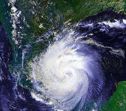 Hurricane Diana approaching landfall in Mexico. | |
| Formed | August 4, 1990 |
|---|---|
| Dissipated | August 9, 1990 |
| Highest winds |
1-minute sustained: 100 mph (155 km/h) |
| Lowest pressure | 980 mbar (hPa); 28.94 inHg |
| Fatalities | 139 total |
| Damage | $90.7 million (1990 USD) |
| Areas affected | Costa Rica, Nicaragua, Honduras, Belize, Yucatán Peninsula, Mainland Mexico |
| Part of the 1990 Atlantic hurricane season, 1990 Pacific hurricane season | |
Hurricane Diana was the deadliest tropical cyclone during the 1990 Atlantic hurricane season, killing 139 people in Mexico. Forming out of a tropical wave on August 4, the system brushed Honduras before intensifying into a tropical storm the following day. Gradually gaining strength, Diana struck the Yucatán Peninsula with winds of 65 mph (100 km/h). Due land interaction, the cyclone weakened slightly before moving over the warm waters of the Bay of Campeche on August 6. Once over water, the Diana quickly became a hurricane and later reached its peak intensity on August 7 as a Category 2 on the Saffir–Simpson Hurricane Scale. Shortly thereafter, the storm made landfall near Tampico, Tamaulipas with winds of 100 mph (165 km/h). Rapid weakening ensued once the storm moved over the high terrain of Mexico and Diana diminished to a tropical depression roughly 24 hours after moving onshore. The cyclone later emerged into the Gulf of California on August 9 before dissipating, though its remnants were monitored until August 14 when the system lost its identity over Arizona.
Throughout Mexico, Hurricane Diana produced torrential rains that triggered deadly flooding and landslides. Roughly 155 mi² (400 km²) of farmland was destroyed and 30,000 people were left homeless by the storm. Numerous roads and railways were either washed out or blocked by debris, cutting communication with several communities. In all, 139 people were killed in the country and $90 million (1990 USD) was wrought in damage. Due to the extensive loss of life and damage caused by Hurricane Diana, its name was retired the following year and replaced with Dolly.
Meteorological history

The origins of Hurricane Diana were from a tropical wave that existed western Africa into the Atlantic on July 27. Conditions were unfavorable for development of a tropical cyclone, and the tropical wave remained disorganized until reaching the eastern Caribbean Sea. The system entered the Caribbean Sea through the southern Windward Islands, where falling barometric pressures were observed, decreasing by 3.5 mbar (hPa; 0.1 inHg) in 24 hours. Upper-level air data from the Lesser Antilles indicated that the tropical wave was associated with an upper-level anticyclone. With increasing convection, the first Air Force reconnaissance plane flight indicated no low-level circulation, but a relatively large amount of thunderstorm activity. The system continued to have a large amount of associated convection while passing over the Netherlands Antilles, as indicated by satellite images and surface observations. Cyclonic rotation was observed in the low-level convection by satellite images, and the fifth tropical depression of the season had developed at 0000 UTC on August 4, situated in the southwestern Caribbean Sea. However, this was based on surface observations, and it was not confirmed that tropical cyclone formation occurred until later that day.[1]
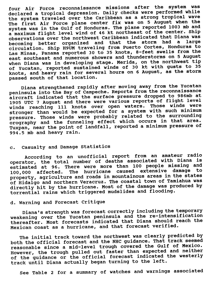
The new tropical depression moved to the northwest under the influence of a mid-level trough, and rapidly intensified to a tropical storm the following day offshore of eastern Honduras; the National Hurricane Center assigned the name Diana to the system. Becoming a tropical storm, Diana further intensified, and winds reached 65 mph (105 km/h) before landfall in Felipe Carrillo Puerto in Quintana Roo occurred. The storm initially rapidly weakened over land, although it retained winds of 50 mph (80 km/h) until moving over open waters. When Diana entered the southern Gulf of Mexico, the trough of low pressure in that vicinity weakened and steering currents caused the storm to head westward. Conditions became more favorable in the Gulf of Mexico, and Diana quickly intensified, becoming a hurricane late on August 7. Hurricane Diana rapidly intensified, and briefly reached Category 2 hurricane status, attaining peak intensity with winds of 100 mph (165 km/h) and a minimum barometric pressure of 980 mbar (hPa; 28.94 inHg). Only two hours after attaining peak intensity on August 7, Hurricane Diana made landfall near Tampico, Tamaulipas at the same intensity.[1]
Moving inland, Diana rapidly weakened over the high terrain of Mexico, quickly deteriorating from a low-end Category 2 hurricane to a strong tropical storm within four hours. Diana continued westward over Mexico, and weakened to a tropical depression on August 8, while centered near Mexico City. The weakening tropical depression turned west-northwestward over central Mexico, and emerged into the Pacific Ocean on August 9, before dissipating in the Gulf of California.[1] The remnants of Hurricane Diana curved northward and tracked through the Gulf of California, and eventually came ashore in northwestern Sonora. Crossing northwestern Mexico, the remnants of Diana entered Arizona and quickly dissipated.[2]
Preparations
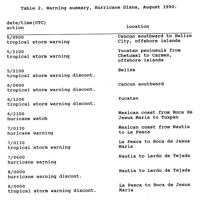
In anticipation of Diana's first landfall, a tropical storm warning was issued on August 5 for Cancún, Mexico southward to Belize City, Belize on August 5, including the offshore islands from both nations; a tropical storm warning indicates that tropical storm force winds, 39 to 73 mph (39 to 118 km/h), are expected within 24 hours. Eleven hours later, the tropical storm warning was extended as far as Carmen, but was discontinued for the entire east coast of Belize.[3] Residents along coastal areas of Quintana Roo were advised to evacuate inland. Emergency officials set up shelters were set up in Xcalak, Punta Herrero and Punta Allen.[4] The Mexican Coast Guard was placed on alert and shipping across Quantana Roo was suspended during the evening of August 5.[5] After Diana made landfall on the Yucatán Peninsula on August 6, all of the tropical storm warnings in place were discontinued.[3]
Nine hours after all warnings were discontinued along the Yucatán Peninsula, Diana began to threaten the mainland east coast of Mexico, and a hurricane watch was issued for Tuxpan to Boca de Jesus Maria; a hurricane watch notes the possibility of hurricane conditions within 48 hours, such as winds of at least 74 mph (119 km/h). Early on August 7, the National Hurricane Center anticipated hurricane conditions within 24 hours, and as a result, a hurricane warning was issued for Nautla to Le Pesca. Simultaneously, a tropical storm warning was issued for La Pesca to Boca de Jesus Maria. Later that day, a hurricane warning had been issued for a similar area, stretching from Nautla to Lerdo de Tejada. By 0000 UTC on August 8, all of the watches and warnings in place were officially discontinued.[3] According to Miguelangel Rebolledo, the captain of the port of Tuxpan, about 300 people fled low-lying areas.[6]
Impact

Mexico
Offshore Quintana Roo, the island Cozumel of reported sustained winds of 45 mph (75 km/h).[7] While crossing over the Yucatán Peninsula, sustained winds of 34 mph (54 km/h) and gusts to 40 mph (65 km/h) were observed in Mérida. In addition, wind gusts of 37 and 45 mph (60 and 73 km/h) were reported in the towns of Felipe Carrillo Puerto and José María Morelos, respectively.[8] Diana also caused heavy rain across the area, though damage is unknown.[9] Due to heavy rainfall, minor street flooding occurred in Chetumal, Quintana Roo.[10]
Rough seas were reported mainly between Coatzacoalcos and Tampico; the ports of those two cities were closed during the passage of Diana, according to the Servicio Meteorológico Nacional. While passing through the Bay of Campeche and the southern Gulf of Mexico, Diana produced waves up to 12 ft (3.6 m) in height.[11] On mainland Mexico, the states of Veracruz, Hidalgo, and Puebla were hardest hit, with over 75,000 people affected by the hurricane.[12] In Poza Rica, high winds toppled trees and electricity poles, which cut off telephone services and electricity supply to the city. Fallen trees and telephone wires also blocked some streets in the area, but the major roads remained open.[6]
Diana produced torrential rainfall while crossing the country, which peaked at 21.92 in (557 mm) in Aquismón, San Luis Potosí.[2] Heavy rainfall triggered mudslides and flooding, mostly in the east-central portion of Mexico. The rainfall caused extensive property damage, destroying numerous houses and leaving 3,500 homeless.[13] The torrential rain blocked highways and railways across six states. Furthermore, the flooding also destroyed 155 mi² (400 km²) of farmland. In addition, it is estimated that Diana injured 25,000 people.[12] Several miners were reported dead, after their truck plunged into a ravine.[14] Excluding the 56 people that were missing by the end of 1990, Hurricane Diana caused 139 deaths, and $90.7 million in damage (1990 USD).[12] However, some sources claim that there were as much as 391 fatalities and losses incurred by the storm totaled to $94.5 million (1990 USD).[15]
Following the storm, the Mexican Armed Forces delivered food and basic health care supplies. In addition, there was also a mass vaccination against typhoid.[16]
Elsewhere
While Diana was crossing the Yucatán Peninsula, it dropped light rainfall in Belize, peaking at 1 in (25 mm) in an unspecified location.[17] The remnants of Hurricane Diana eventually moved into the Southwestern United States, bringing heavy rainfall to the region.[2] In Imperial County, California, golf-ball sized hail was reported by the residents, along with rain and lightning, causing briefly power outages throughout the county. A police dispatch of Imperial County also noted local flooding, which resulted in traffic disruptions.[18] The remnants of Diana also dropped light rainfall in San Diego County, California, with the city of San Diego receiving only a trace of rain, Vista reporting 0.09 in (2 mm), Del Mar had 0.08 in (2 mm), and Oceanside measuring 0.3 in (8 mm).[19]
In Arizona, the remnants of Diana contributed to record cold temperatures for August in Phoenix. On August 14, the city had a high temperature of 78 °F (26 °C), which was 24 °F (−4 °C) below normal for that date. In Maricopa County, 3.5 in (89 mm) of rain was observed. Heavy precipitation, with 3.42 in (87 mm) in Desert Hills, which fell in less than two hours. Several weather-related car accidents occurred, but none were serious. In Apache Junction, police and city officials rushed to close flooded streets, including portions of state highways and underpasses of Interstate 17. Crews were pumping 32,000 US gal (120,000 L) of water from the underpasses of Interstate 17, but their efforts were futile. A 19 mi (31 km) portion of State Route 87 between Gila River Indian Community and the intersection with State Route 187 was shut down due to flooding. In Sacaton, about two-thirds of the city was inundated with at least 3 ft (0.91 m) of water.[20]
Due to its impact, the name Diana was retired by the World Meteorological Organization in the spring of 1991, and will never be used again for another Atlantic hurricane. It was replaced with Dolly for the 1996 season. This Hurricane Diana is not to be confused with the 1955 season's Hurricane Diane, which was also retired.[21]
See also
- List of tropical cyclones
- List of Atlantic hurricanes
- List of Atlantic–Pacific crossover hurricanes
- Other storms named Diana
References
- 1 2 3 Lixion A. Avila (1990). Hurricane Diana Preliminary Report (Report). Miami, Florida: National Hurricane Center. p. 1. Retrieved December 18, 2013.
- 1 2 3 David R. Roth (January 27, 2007). Hurricane Diana - August 4–14, 1990 (Report). College Park, Maryland: Weather Prediction Center. Retrieved December 18, 2013.
- 1 2 3 Lixion A. Avila (1990). Hurricane Diana Preliminary Report (Report). Miami, Florida: National Hurricane Center. p. 5. Retrieved December 18, 2013.
- ↑ "Tropical Storm Whips Yucutan". Mexico City, Mexico. Associated Press. August 5, 1990. (Accessed through LexisNexis)
- ↑ "Diana threatens Yucatan with 45 mph winds". Chetumal, Mexico. United Press International. August 5, 1990. (Accessed through LexisNexis)
- 1 2 "Hurricane Diana batters Mexico's Gulf Coast". Observer-Reporter. Poza Rica, Mexico. Associated Press. August 7, 1990. p. 35. Retrieved December 18, 2013.
- ↑ History for Cancun, Mexico (Report). Weather Underground. Retrieved December 18, 2013.
- ↑ "Diana headed back out into the Gulf". Williamson Daily News. Mexico City, Mexico. Associated Press. August 7, 1990. p. 1. Retrieved December 18, 2013.
- ↑ Lixion A. Avila (1990). Hurricane Diana Preliminary Report (Report). Miami, Florida: National Hurricane Center. p. 2. Retrieved December 18, 2013.
- ↑ "Tropical storm moves toward gulf". Reading Eagle. Mexico City, Mexico. August 5, 1990. p. 142. Retrieved December 18, 2013.
- ↑ "Hurricane Hits Mexican Coast, Loses Strength". Los Angeles Times. Los Angeles, California. August 8, 1990. Retrieved December 18, 2013.
- 1 2 3 (Spanish) Efectos Económicos de los Principales Desastres según Tipo de Fenómen (PDF) (Report). Pan American Health Organization. 1990. Archived from the original (PDF) on June 25, 2008. Retrieved November 2, 2010.
- ↑ 1990 Global Register of Major Flood Events (Report). Dartmouth College. May 2, 2006. Retrieved December 18, 2013.
- ↑ "Hurricane kills at least 35, wreaks havoc in Mexico". Deseret News. Salt Lake City, Utah. August 10, 1990. Retrieved December 18, 2013.
- ↑ (Spanish) Siste Sistemas De Alertamiento Temprano Y Difusion De La Informacion Experiencias En Mexico (PDF). El Centro Nacional De Prevencion De Desastres (Report). CENAPRED. November 2001. Archived from the original (PDF) on April 25, 2012. Retrieved November 29, 2011.
- ↑ "Huracan Diana Causo 81 Muertos". Explored.com. Mexico City, Mexico. August 14, 1990. Retrieved December 18, 2013.
- ↑ Frappier (2007). Recent Tropical Cyclones Near Central Belize (PDF) (Report). Geological Society of America. Retrieved December 18, 2013.
- ↑ "Remnants of Hurricane Diana Blamed for Rain in Southland". Los Angeles Times. Los Angeles, California. August 16, 1990. Retrieved December 18, 2013.
- ↑ "San Diego Skies Get Ahead of Themselves". Los Angeles Times. Los Angeles, California. August 16, 1990. Retrieved December 18, 2013.
- ↑ "Heavy rains cause flooding". The Kingman Daily Miner. Phoenix, Arizona. Associated Press. August 15, 1990. p. 7. Retrieved December 18, 2013.
- ↑ Retired Hurricane Names Since 1954. National Hurricane Center (Report). Miami, Florida: National Oceanic and Atmospheric Administration. April 11, 2013. Retrieved December 18, 2013.
External links
| Wikimedia Commons has media related to Hurricane Diana. |
- NHC Diana report (GIF format)
- HPC Diana Rainfall page
| 1950s | |
|---|---|
| 1960s | |
| 1970s | |
| 1980s | |
| 1990s | |
| 2000s | |
| 2010s | |
| |
Tropical cyclones of the 1990 Atlantic hurricane season | ||
|---|---|---|
 | ||
| ||