1923 Atlantic hurricane season
| |
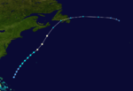
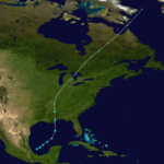
| Season summary map |
| First system formed |
June 19, 1923 |
| Last system dissipated |
October 26, 1923 |
| Strongest storm1 |
Five – 965 mbar (hPa) (28.5 inHg), 120 mph (195 km/h) |
| Total storms |
9 |
| Hurricanes |
4 |
| Major hurricanes (Cat. 3+) |
1 |
| Total fatalities |
None |
| Total damage |
Unknown |
| 1Strongest storm is determined by lowest pressure |
Atlantic hurricane seasons
1921, 1922, 1923, 1924, 1925 |
The 1923 Atlantic hurricane season ran its course from
Summer through Fall of 1923. The season was slightly below average with 9 tropical storms; of which 4 became hurricanes, and one became a major hurricane.
Timeline
Storms
Tropical Depression
On June 19 a weak tropical depression formed from the tail end of a dying cold front, north of Western Bahamas and east of Florida. The tropical depression moved generally north after its formation. Failing to intensify further it was absorbed by a stronger cold front sweeping down the East Coast on June 22. The peak winds from this system were 25 knts (30 mph, 45 km/h) from ship observations on June 19. The lowest pressure was 1012 millibars. Due to the weak nature of this system and lack of gale winds it was evaluated as a tropical depression and was not included in HURDAT. In 2009 this tropical depression was first detected from Historical Weather Maps when Landsea and his team of researchers did a total reanalysis of the 1923 Atlantic hurricane season.[1]
Tropical Storm One
| Tropical storm (SSHWS) |
|
|
| Duration |
June 22 – June 28 |
| Peak intensity |
60 mph (95 km/h) (1-min) <999 mbar (hPa) |
Early on June 22 a broad area of low pressure was observed in the Bay of Campeche where it intensified into a tropical depression later that day. It remained at that intensity for the next three days while it drifted slowly to the northeast while its pressure continued to gradually fall. By late June 25 it had begun to become better organized and move more swiftly to the north-northeast as a tropical storm. Tropical Storm One clipped the southeastern point of Louisiana
and made landfall as a minimal tropical storm over extreme southern Mississippi and Alabama on June 26. Excessive rains fell in the vicinity of the cyclone and all the way up the east coast. The system weakened into a tropical depression late on the 26 while it was over Southeastern Alabama. It turned in a more easterly direction as the influence of an extratropical low to the northwest became more apparent. On June 27 it regained tropical storm intensity as it reached the Atlantic Ocean off the Georgia-South Carolina coast. On the 28th it reached a peak intensity of 60 mph (95 km/h) and a peripheral pressure of 999 millibars. At this time the extra tropical system to the north west began to affect this tropical storm more heavily and by early June 29 it had lost the characteristics of a tropical system. This storm was first introduced to HURDAT in a 2009 reanalysis of the basin.[2]
Hurricane Two
| Category 2 hurricane (SSHWS) |
|
|
| Duration |
September 1 – September 9 |
| Peak intensity |
105 mph (165 km/h) (1-min) <989 mbar (hPa) |
The season began late with a tropical storm observed northeast of Turks and Caicos on August 30. The cyclone turned north and then northeast, very close to Bermuda, before becoming a hurricane. After passing Bermuda and reaching hurricane strength, the storm turned north and slowed down. For two days, the storm drifted slowly northward across the Atlantic, reaching a peak intensity of 105 mph (169 km/h). On September 8, the storm weakened to a Category 1 hurricane and began to accelerate while curving slightly to the northeast. The storm became extratropical shortly before striking Newfoundland, on the evening of September 9. No damage was reported.
Tropical Storm Three
| Tropical storm (SSHWS) |
|
|
| Duration |
September 7 – September 11 |
| Peak intensity |
50 mph (85 km/h) (1-min) <1000 mbar (hPa) |
This tropical storm formed near the coast of Africa on September 7, however it was short lived and never approached land.
Hurricane Four
| Category 1 hurricane (SSHWS) |
|
|
| Duration |
September 10 – September 13 |
| Peak intensity |
80 mph (130 km/h) (1-min) <986 mbar (hPa) |
A tropical storm formed near the coast of the US on September 10. It intensified on September 12, but that was short-lived and weakened rapidly into an extropical force, which then made landfall in Canada. Damage was minimal.
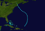
Hurricane Five
| Category 3 hurricane (SSHWS) |
|
|
| Duration |
September 24 – October 1 |
| Peak intensity |
120 mph (195 km/h) (1-min) <965 mbar (hPa) |
Hurricane Five, the season's only major hurricane, was discovered north of Hispaniola on September 24. It passed through the Bahamas as a strengthening hurricane, and recurved northeast as it approached the southeastern United States. The storm began to weaken as it entered the cooler waters of the north Atlantic, finally dissolving into a powerful extratropical cyclone affecting Newfoundland with hurricane-force winds. Damage, however, was minimal in all affected areas.
Hurricane Six
| Category 1 hurricane (SSHWS) |
|
|
| Duration |
October 12 – October 17 |
| Peak intensity |
80 mph (130 km/h) (1-min) 983 mbar (hPa) |
The sixth storm of 1923 was the first recorded example of a storm crossing from the Eastern Pacific basin into the Atlantic basin. It formed in the deep tropical latitudes south of Guatemala in mid-October. The storm struck the Mexican state of Oaxaca on October 13, crossing the Isthmus of Tehuantepec into the Bay of Campeche. It strengthened into a hurricane while continuing northward across the Gulf of Mexico, making landfall along Atchafalaya Bay, Louisiana as a Category 1. Damage was restricted to harbor areas, including sunken barges or barges driven ashore. There were reports of downed trees and telegraph poles.
Tropical Storm Seven
| Tropical storm (SSHWS) |
|
|
| Duration |
October 15 – October 19 |
| Peak intensity |
65 mph (100 km/h) (1-min) <987 mbar (hPa) |
Storm number five formed north of the Leeward Islands on October 15, and moved northeast for its first two days before recurving back to the northwest. The storm never strengthened much and struck Cape Cod as a weakening tropical storm. The highest wind gust reported was 48 mph (77 km/h) on Nantucket.
Tropical Storm Eight
| Tropical storm (SSHWS) |
|
|
| Duration |
October 16 – October 18 |
| Peak intensity |
60 mph (95 km/h) (1-min) 992 mbar (hPa) |
Tropical Storm Eight was a large but disorganized system, developing in the central Gulf of Mexico on October 16. Its formation meant, for a brief time on October 16, there were three tropical storms active in the Atlantic simultaneously, a rare occurrence. The storm moved northeast, gaining little intensity and striking the Mississippi coast with 45 mph (72 km/h) sustained winds. The strongest gust reported was 56 mph (90 km/h) at Pensacola, Florida.
Tropical Storm Nine
| Tropical storm (SSHWS) |
|
|
| Duration |
October 24 – October 26 |
| Peak intensity |
45 mph (75 km/h) (1-min) <1003 mbar (hPa) |
Storm seven was not mentioned in the Monthly Weather Review and little is known about it beyond the official track record. It formed in late October, north of the Leeward Islands, and moved northward before turning northwest. The storm never gained much intensity, and lost its identity south of Bermuda. Its extratropical remnant likely brought gusty winds to Bermuda.
See also
References
External links