1949 Texas hurricane
| Category 2 hurricane (SSHWS/NWS) | |
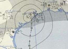 Map of the hurricane on October 4 | |
| Formed | September 27, 1949 |
|---|---|
| Dissipated | October 7, 1949 |
| (Extratropical after October 5) | |
| Highest winds |
1-minute sustained: 110 mph (175 km/h) |
| Lowest pressure | 965 mbar (hPa); 28.5 inHg |
| Fatalities | 2 total |
| Damage | $6.7 million (1949 USD) |
| Areas affected | El Salvador, Guatemala, Honduras, Mexico, Belize, Texas, Louisiana, Arkansas, Missouri, Illinois |
| Part of the 1949 Atlantic hurricane season 1949 Pacific hurricane season | |
The 1949 Texas hurricane was an intense tropical cyclone of the 1949 Atlantic hurricane season. Forming in the Pacific Ocean on September 27, the storm crossed into the Gulf of Mexico—one of only a handful of known storms to do so—and began to intensify. It ultimately peaked with winds corresponding to high-end Category 2 status on the modern-day Saffir–Simpson Hurricane Scale and made landfall near Freeport, Texas, on the morning of October 4. It rapidly weakened after moving inland and dissipated several days later. Damage from the storm was moderate, although the hurricane temporarily cut off the city of Galveston from the mainland. Rice crops suffered extensive damage, with losses estimated at up to $10 million (1949 USD, $99.6 million 2016 USD). Two people died due to the hurricane.
Meteorological history

According to modern-day analysis, a tropical depression developed in the Pacific Ocean, south of El Salvador, early on September 27. It drifted northward across Central America and eastern Mexico before emerging into the Gulf of Mexico near Ciudad del Carmen on September 30. Weather reports had indicated low air pressures over the area for several days.[1][2] It is relatively rare for a tropical cyclone to cross from the Pacific into the Atlantic, or vice versa, and this storm is among less than a dozen known to have officially done so.[3] Only three other tropical cyclones have crossed from the eastern Pacific into the Gulf of Mexico.[4]
The cyclone intensified into a tropical storm on October 1 and sped up slightly as it curved northwestward. A day later it became a hurricane. Subsequently, a period of rapid intensification took place, and as the cyclone approached the Texas coast on October 3, it attained peak winds of 110 miles per hour (177 km/h), equivalent to upper-end Category 2—almost Category 3—intensity.[1] The storm moved ashore early the next day just east of Bay City with a barometric pressure estimated at 965 millibars (28.50 inHg). The storm is one of a relatively few October hurricanes to either impact or make landfall in Texas.[5] After significantly weakening, it passed directly over Houston; the next storm to do so would be Hurricane Alicia in 1983.[6]
Upon moving inland, the hurricane quickly degraded into a tropical storm within six hours of making landfall.[1] It turned northeastward as it continued through the central United States, weakening to a tropical depression by October 5. It became extratropical the next day, yet persisted until October 7, when it is believed to have dissipated near Sheboygan, Wisconsin.[1]
Preparations and impact
Throughout 10 cities in Texas, 50,000 sought shelter in advance of the hurricane.[7] An estimated 28,000 residents fled to shelters; around 5,000 stayed in the Houston City Auditorium.[8] Tropical cyclone watches and warnings were issued along coastal areas of Texas and Louisiana.[9] Pioneer Airlines removed its aircraft from Houston, while small watercraft were kept safe in port.[10] Schools in Corpus Christi closed by October 3, as well as businesses in the threatened area.[11]
The hurricane produced gusts of 135 mph (217 km/h) just west of Freeport, accompanied by an air pressure of 28.88 inches of mercury (978 hPa) and tides of 11.4 ft (3.5 m) above normal.[4] Precipitation from the storm was heavy, peaking at 14.5 in (370 mm) at Goodrich.[2] Rainfall extended eastward into Louisiana, amounting to 6.81 in (173 mm) at Shreveport, Louisiana.[12] Urban areas sustained generally light damage. In Houston, the winds shattered some store windows and distributed debris.[13] Galveston was temporarily cut off from the mainland during the hurricane when water surpassed the city's seawall. The hurricane spawned a minor tornado which struck the community of Riceville, injuring on two children.[12] Freeport reportedly suffered the worst damage, costing approximately $150,000.[14]
A pier at Port Aransas was largely destroyed at a cost of $10,000. The hurricane caused extensive damage to rice, cotton, and vegetable crops in the region.[15] An estimate several days after the storm placed the total quantity of rice damaged at 500,000 bushels, totaling $10 million in monetary losses.[16] However, Zoch (1949) reported that total damage from the storm was $6.7 million.[2] Following the storm, thousands of automobiles in six states were affected by widespread peeling and blistering paint. The blisters, usually concentrated on the hoods, fenders and tops of vehicles, contained a small amount of water, and peeling paint was also reported on one Shreveport home. Most of the cars damaged were parked outside, and sheltered automobiles were unaffected. Although total damage from the phenomenon may have reached thousands of dollars, experts were unable to identify its cause immediately following the storm.[17] Two deaths were attributed to the storm: a resident of Port Neches who was electrocuted, and a young woman who drowned in Matagorda Bay.[12]
See also
References
- 1 2 3 4 National Hurricane Center; Hurricane Research Division (July 6, 2016). "Atlantic hurricane best track (HURDAT version 2)". United States National Oceanic and Atmospheric Administration. Retrieved December 5, 2016.
- 1 2 3 Richmond T. Zoch (December 1949). "North Atlantic Hurricanes and Tropical Disturbances of 1949" (PDF). Monthly Weather Review. American Meteorological Society. 77 (12). Retrieved May 20, 2010.
- ↑ Atlantic Oceanographic and Meteorological Laboratory. "Subject: E15) What tropical storms and hurricanes have moved from the Atlantic to the Northeast Pacific or vice versa?". National Oceanic and Atmospheric Administration. Archived from the original on 27 May 2010. Retrieved May 20, 2010.
- 1 2 David Roth. "Texas Hurricane History" (PDF). Hydrometeorological Prediction Center. Archived (PDF) from the original on 28 May 2010. Retrieved May 20, 2010.
- ↑ National Hurricane Center; Hurricane Research Division; Atlantic Oceanographic and Meteorological Laboratory (February 2015). "Continental United States Hurricanes (Detailed Description)". aoml.noaa.gov. Miami: United States National Oceanic and Atmospheric Administration's Office of Oceanic & Atmospheric Research. Retrieved December 5, 2016.
- ↑ Bryan Norcross (2007). Hurricane Almanac: The Essential Guide to Storms Past, Present, and Future. Macmillan. p. 59. ISBN 0-312-37152-7. Retrieved 20 May 2010.
- ↑ "Hurricane Drives 50,000 From Homes". The Sydney Morning Herald. October 5, 1949. Retrieved May 20, 2010.
- ↑ "Gulf Hurricane Dies Out After Hitting Crops". Pittsburgh Post-Gazette. October 5, 1949. Retrieved May 20, 2010.
- ↑ "Hurricane Heading for Texas Coast". Miami News. October 3, 1949. Retrieved May 20, 2010.
- ↑ "Hurricane Smashes Into Texas Coast". Palm Beach Post. October 4, 1949. Retrieved May 20, 2010.
- ↑ "Hurricane Moves in on Texas Coast". Spokane Daily Chronicle. October 3, 1949. Retrieved May 20, 2010.
- 1 2 3 "Hurricane Kills 2, Then Losses Force". The Pittsburgh Press. October 4, 1949. Retrieved May 20, 2010.
- ↑ "Hurricane Blasts Rich Texas Crops". Spokane Daily Chronicle. October 4, 1949. Retrieved May 20, 2010.
- ↑ "Two Are Killed In Texas Storm". Toledo Blade. October 5, 1949. Retrieved May 20, 2010.
- ↑ "Hurricane Fizzling Out After Blasting Texas". The Victoria Advocate. October 4, 1949. Retrieved May 20, 2010.
- ↑ "Rice Crop Damaged". The Pittsburgh Press. October 9, 1949. Retrieved May 20, 2010.
- ↑ "'Plague' Hits Autos in Wake of Hurricane". Chicago Daily Tribune. October 7, 1949.
Tropical cyclones of the 1949 Atlantic hurricane season | ||
|---|---|---|
 | ||
| ||