Hurricane Isidore
| Category 3 major hurricane (SSHWS/NWS) | |
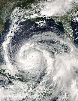 Hurricane Isidore at peak intensity just off the coast of Mexico on September 22 | |
| Formed | September 14, 2002 |
|---|---|
| Dissipated | September 27, 2002 |
| Highest winds |
1-minute sustained: 125 mph (205 km/h) |
| Lowest pressure | 934 mbar (hPa); 27.58 inHg |
| Fatalities | 19 direct, 3 indirect |
| Damage | $1.3 billion (2002 USD) |
| Areas affected | Venezuela, Jamaica, Cayman Islands, Cuba, Yucatán Peninsula, Louisiana, Mississippi |
| Part of the 2002 Atlantic hurricane season | |
Hurricane Isidore was the ninth named storm and the second hurricane in the 2002 Atlantic hurricane season. Isidore was the fifth of eight named storms to occur in September.[1] The tropical cyclone peaked as a Category 3 hurricane, causing damage as well as four fatalities in Jamaica, Cuba, Mexico, and the United States.[2] Isidore is noted for threatening to strike the northern Gulf Coast as a Category 4 hurricane, but instead striking as a moderate tropical storm due to a track change that brought the storm over the Yucatán Peninsula for over a day, which significantly weakened the cyclone. Its primary impact was the heavy rainfall which fell across southeast Mexico and from the central United States Gulf coast into the Ohio Valley.[3]
Meteorological history

On September 9, a tropical wave moved off the coast of Africa. Despite moving through a dry environment, its convection became organized as an anticyclone developed over the wave. On September 14, convection was well-organized enough around a small closed wind circulation to classify the system as Tropical Depression Ten near Trinidad and Tobago.[2] Land interaction from Venezuela later weakened the depression back to a tropical wave. The wave continued west-northwestward through the Caribbean, and redeveloped into a tropical depression on September 17 while 140 miles (230 km) south of Jamaica.[4]
Embedded within a weak steering current, it drifted to the northwest, and strengthened into Tropical Storm Isidore on September 18 near Jamaica.[5] After grazing the island, it quickly intensified to a hurricane late on September 19 while south of Cuba. Isidore's maximum sustained winds reached 100 miles per hour (160 km/h) near the Isle of Youth, and weakened slightly to an 85 miles per hour (137 km/h) hurricane as it made landfall on Cabo Frances late on September 20.[1] The hurricane crossed the island, then slowed as it moved westward across the Gulf of Mexico. Favorable conditions aloft with warm water temperatures allowed Isidore to quickly intensify to a peak of 125 miles per hour (201 km/h) winds on September 21.[6]
.gif)
Despite Dvorak satellite estimates of 145 miles per hour (233 km/h), reconnaissance aircraft indicated Isidore remained a 125 miles per hour (201 km/h) Category 3 hurricane, with pressures dropping to 934 mbar (27.6 inHg), typical of a Category 4 hurricane.[7] It is the lowest minimum pressure ever observed for an Atlantic hurricane which did not exceed Category 3 intensity.[1] With nearly ideal conditions for development, Isidore was forecast to reach winds of 150 miles per hour (240 km/h) over the northern Gulf of Mexico.[8] High pressures to its north forced it southward, and Isidore made landfall at Telchac Puerto in Yucatán as a major hurricane on September 22. It weakened rapidly as it nearly stalled over Yucatán, and was only a minimal tropical storm after being inland for 30 hours.
The inner core of convection collapsed while over southeast Mexico, and upon moving northward and reaching the Gulf of Mexico again, it was a large but weak tropical storm. Conditions favored significant strengthening, but Isidore did not redevelop central convection until reaching the northern Gulf of Mexico. The strengthening system hit Grand Isle, Louisiana on September 26 as a 65 miles per hour (105 km/h) tropical storm, but weakened quickly into a tropical depression after moving inland. The system raced to the northeast, and became an extratropical cyclone on September 27 before becoming absorbed in a frontal zone over Pennsylvania that night.[9]
Preparations
Before Isidore became a hurricane, there were fears that the storm would end up being a significant threat.[2] The upper level environment ahead of the storm was very favorable, and the oceanic heat content was very high.[10] Just ten months after the destructive Hurricane Michelle, Hurricane Isidore threatened to cause similar effects in Cuba. In preparation for the storm, about 292,000 people and thousands of farm animals were evacuated in the Pinar del Río province.[11][12] Hurricane Warnings were posted about 48 hours before landfall, leaving ample time to prepare for the storm.
Once in the Gulf of Mexico, Hurricane Isidore became a major Category 3 storm with winds of 125 miles per hour (201 km/h).[1] The forecasts then predicted Isidore to move westward in the Gulf of Mexico for a few days, before turning northward towards the Gulf Coast as what was predicted by then to be a strong Category 4 hurricane.[13] Initially expected to remain north of the peninsula, hurricane warnings were issued just over a day prior to landfall, with no watch preceding Isidore's passage.[14][15] More than 70,000 people were evacuated,[16] and ports on the Gulf coast of Yucatán were closed. Mexican authorities declared a state of emergency prior to the arrival of the storm.[17] Due to Isidore's unexpected southward turn into the Yucatán Peninsula, Isidore weakened significantly to a tropical storm which limited potential damage along the United States Gulf Coast. In preparation for the hurricane, the Red Cross mobilized its members across Texas, Alabama, Louisiana, Mississippi, and Florida days before Isidore's expected landfall.[16] Volunteers were sent in the days prior to ensure families had a family disaster plan and a disaster supplies kit in their household. Hurricane watches raised for the United States Gulf coast between Cameron, Louisiana and Pascagoula, Mississippi late on the morning of September 24 were discontinued early on the morning of September 25, when the storm was no longer expected to restrengthen into a hurricane.[5]
Impact
Caribbean islands
In the Windward Islands, Isidore was a weak tropical depression that caused no reported damage or casualties. The Cayman Islands reported tropical storm force winds, and likely experienced flooding to some degree, but Isidore caused no reported damage or casualties. Isidore brought heavy rains to Jamaica, totalling 27.2 inches (690 mm) at Cotton Tree Gully.[5]
Cuba
Hurricane Isidore brought torrential rainfall, with many areas reporting over 1 foot (300 mm) of rain. The maximum reported was 21.7 inches (550 mm) at Isabel Rubio in western Cuba.[5] The rainfall, combined with a 12 feet (3.7 m) storm surge, destroyed 77 houses,[11] caused power outages, uprooted trees and blew off roofs.[18] Over 130 tobacco drying houses were affected to some degree, damaging valuable tobacco stock.[12] A total of 24,000 metric tons of citrus and 132 metric tons of coffee were lost from the storm. Thousands of livestock perished.[18] No deaths were reported.
Southeast Mexico

Hurricane Isidore was one of only four storms to hit the north side of the Yucatán since records have been kept. It was the first tropical cyclone to hit the area since Tropical Depression Greta in 1970, the first tropical storm since 1935, the first hurricane since 1888, and only major hurricane to ever hit the area.[1]
The storm shut down oil production of the Mexican state-run oil company, PEMEX. Drilling operations, as well as exports from Mexico, stopped for one week which cost the oil company US$108.7 million.[19] The Gulf Coast island of Isla Arena was nearly covered by Isidore's storm surge. Its residents evacuated prior to the storm's passage.[20]
Hurricane Isidore hit near Mérida, Yucatán, as a 125 miles per hour (201 km/h) hurricane, and remained over the area for around 36 hours. Over 30 inches (760 mm) of rainfall fell, with the maximum recorded near Campeche.[3] The storm surge reached as high as 6 metres (20 ft) over southern portions of Yucatán state. Nearly one-third of all fishing vessels were damaged by Isidore.[21] Nearly 36,500 houses were destroyed in Yucatán from the intense winds,[21] 83,000 homes damaged, and 500,000 were left homeless.[19] Downed trees and power lines were common over much of the northern Yucatán Peninsula,[22] and 75% of barns and warehouses were either severely damage or destroyed. Damage to crops and livestock was extreme; 2,000 square kilometres of maize and 400 square kilometres of fruit trees were damaged across the country.[23] A total of 70% of the poultry production and livestock were lost during the storm in Yucatán. Damage to Mexico's power grid reached US$19.76 million. Over one-fourth of the roads across the peninsula were moderately or severely damaged, which resulted in losses of US$9.88 million to rural areas.[19] Farming in Campeche experienced significant damage, with 30,000 cattle and 100,000 acres (400 km²) of agricultural land lost.
Throughout the Yucatán Peninsula, there were 17 deaths were attributed to Hurricane Isidore, two of which were indirectly related to the storm. Damage in the country totaled $950 million (2002 USD).[20][24]
Central America
Isidore caused heavy rains in Guatemala due to upslope flow from the Pacific Ocean, which led to landslides and flooding across southern and western portions of the country. The rains led to the drowning of two people when they tried to cross a rain-swollen river. Three hundred and fifty households reported losses.[18][20]
Eastern United States
In the open Gulf of Mexico, Hurricane Isidore and later Hurricane Lili contributed to the shutdown of offshore oil and gas platforms. The effects of back-to-back storms resulted in the loss of production of 14.4 million barrels (2,290,000 m3) of oil and 88.9 billion cubic feet (2.52×10⁹ m3) of natural gas. A storm surge of 8.3 feet (2.5 m) was measured at Rigoletes, Louisiana and at Gulfport Harbor, Mississippi.[5] Hurricane Isidore brought widespread heavy rainfall from the central Gulf coast into the Ohio Valley, with a maximum of 15.97 inches (406 mm) at Metairie, Louisiana.[3] The flooding was responsible for moderate crop damage, with a total of $330 million in damage (2002 USD, 360 million 2006 USD).[25] Isidore claimed five lives; four direct and one indirect. The indirect death was from a man that went into cardiac arrest in Mississippi, whereas the other four were drowning deaths.[5]
Retirement
The name Isidore was retired in the spring of 2003 and will never be used for an Atlantic hurricane again.[26] It was replaced with Ike in the 2008 season. That name itself was retired and replaced with Isaias after Hurricane Ike caused immense destruction in the United States and Cuba.
See also
- Hurricane Carmen
- List of Atlantic hurricanes
- List of retired Atlantic hurricane names
- List of wettest tropical cyclones in the United States
- List of wettest tropical cyclones in Jamaica
- List of Florida hurricanes (2000–present)
- List of North Carolina hurricanes (1980–present)
References
- 1 2 3 4 5 National Hurricane Center; Hurricane Research Division (July 6, 2016). "Atlantic hurricane best track (HURDAT version 2)". United States National Oceanic and Atmospheric Administration. Retrieved December 8, 2016.
- 1 2 3 Lixion Avila. TROPICAL DEPRESSION TEN DISCUSSION NUMBER 1. Retrieved on 2008-02-28.
- 1 2 3 David M. Roth. Black Background, color-filled rainfall graphic for Isidore. Retrieved on 2008-02-28.
- ↑ James Franklin. TROPICAL DEPRESSION TEN DISCUSSION NUMBER 6. Retrieved on 2008-02-28.
- 1 2 3 4 5 6 Lixion Avila. Tropical Cyclone Report: Hurricane Isidore 14 - September 27, 2002. Retrieved on 2015-05-26.
- ↑ Stacey Stewart. HURRICANE ISIDORE DISCUSSION NUMBER 22. Retrieved on 2008-03-27.
- ↑ Stacy Stewart. HURRICANE ISIDORE DISCUSSION NUMBER 26. Retrieved on 2008-02-28.
- ↑ Stacey Stewart. HURRICANE ISIDORE DISCUSSION NUMBER 23. Retrieved on 2008-02-28.
- ↑ Andrew Orrison. PUBLIC ADVISORY NUMBER 47 FOR TROPICAL DEPRESSION ISIDORE. Retrieved on 2008-02-28.
- ↑ James Franklin. TROPICAL DEPRESSION TEN DISCUSSION NUMBER 7. Retrieved on 2008-03-03.
- 1 2 World Food Programme. Emergency Report n. 39 September 27, 2002. Retrieved on 2008-03-06.
- 1 2 Cuba-Junky. Cuba : Hurricanes & Cyclones in Cuba. Retrieved on 2008-03-03.
- ↑ Stacey Stewart. HURRICANE ISIDORE DISCUSSION NUMBER 27. Retrieved on 2008-03-03.
- ↑ Lixion Avila. HURRICANE ISIDORE ADVISORY NUMBER 20. Retrieved on 2008-03-03.
- ↑ Miles Lawrence. HURRICANE ISIDORE ADVISORY NUMBER 21. Retrieved on 2008-03-03.
- 1 2 Mason Anderson. Red Cross Urges Hurricane Preparedness as Three Storms Strengthen. Retrieved on 2008-03-27.
- ↑ BBC. Hurricane Isidore threatens Mexico. Retrieved on 2008-03-27.
- 1 2 3 ReliefWeb. ODM-WFP emergency situation report on Latin America & the Caribbean Oct 10, 2002. Retrieved on 2008-03-06.
- 1 2 3 SourceMex Economic News & Analysis on Mexico. FEDERAL, STATE GOVERNMENTS ACCUSED OF MISHANDLING ASSISTANCE EFFORTS TO VICTIMS OF HURRICANE ISIDORE. Retrieved on 2008-03-06.
- 1 2 3 USA Today. Isidore pummels Mexico's Yucatan Peninsula. Retrieved on 2008-03-06.
- 1 2 MWH. Linking Climate Change Adaptation and Disaster Risk Management for Sustainable Poverty Reduction. Retrieved on 2008-03-06.
- ↑ Associated Press. Hurricane Isidore batters Yucatan Peninsula, could head toward U.S. Gulf coast. Retrieved on 2008-03-06.
- ↑ International Federation of Red Cross and Red Crescent Societies. Programme Update. Retrieved on 2008-03-06.
- ↑ Cenapred, Cepal y Servicio Sismológico Nacional (2008). "Principales desastres naturales, 1980–2005" (PDF) (in Spanish). El Almanaque Mexicano 2008. Retrieved 2009-06-17.
- ↑ John L. Beven II, Richard J. Pasch and Miles B. Lawrence. Atlantic Hurricane Season of 2002. Retrieved on 2008-03-06.
- ↑ National Hurricane Center. Frequently Asked Questions. Subject: B3) What names have been retired in the Atlantic and East Pacific basin? Retrieved on 2008-02-28.
External links
| Wikimedia Commons has media related to Hurricane Isidore. |
- NHC Hurricane Isidore Tropical Cyclone Report
- NHC advisory archives for Hurricane Isidore
- Hydrometeorological Prediction Center advisory archive on Tropical Depression Isidore
- Cuba effects
- Red Cross Preparation
- Yucatan effects
- Oil and Gas Production
- Hurricane Isidore Photographs - New Orleans Lake Front
| 1950s | |
|---|---|
| 1960s | |
| 1970s | |
| 1980s | |
| 1990s | |
| 2000s | |
| 2010s | |
| |
Tropical cyclones of the 2002 Atlantic hurricane season | ||
|---|---|---|
 | ||
| ||